


A Dense Fog Advisory is in effect until 10:00 a.m. for much of North Texas. A Freezing Fog Advisory is in effect until 10:00 a.m. for areas north of the Dallas-Fort Worth area. Use extra caution on elevated roadways in these areas.
We're starting off this morning in the 30s, but will warm quickly into the middle 50s with plenty of sunshine this afternoon.
 National Weather Service - Fort Worth
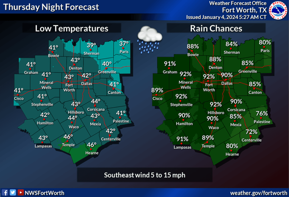
Clouds roll in quickly this evening with a good chance of rain after 10:00 p.m. The rain will continue overnight and will end from west to east tomorrow morning. Morning lows will dip into the low to mid-40s.
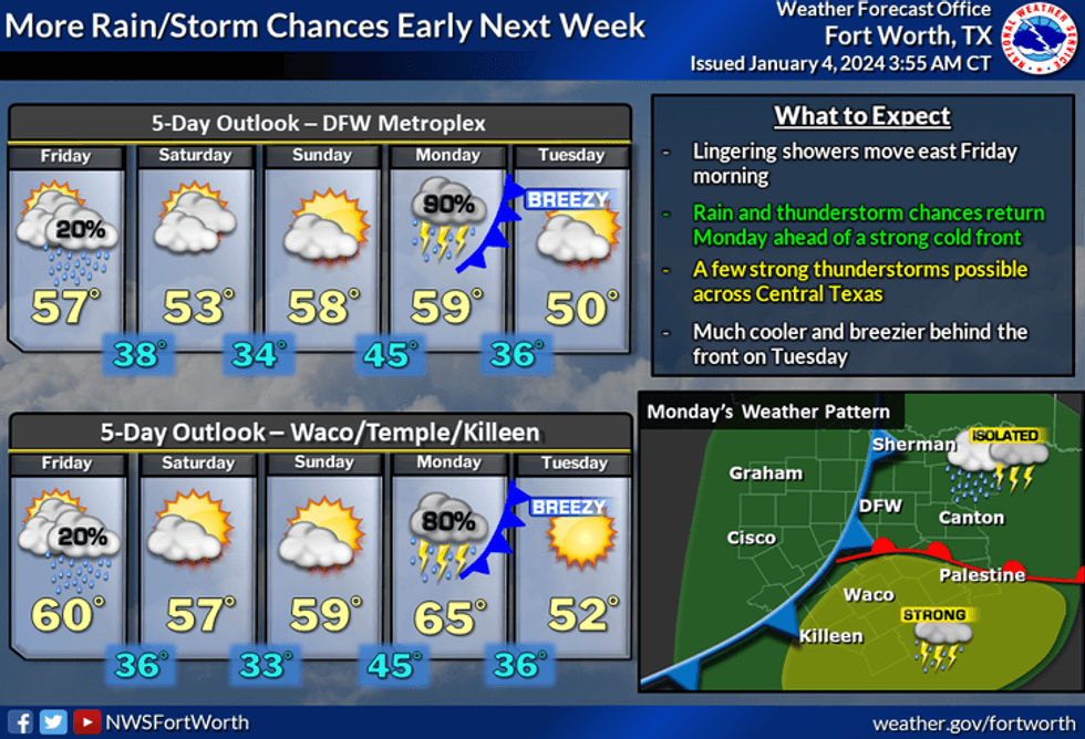
We'll get some wrap-around moisture tomorrow afternoon and evening so that the cloud cover will be in and out. Don't be surprised if you see a few sprinkles as well, especially north of Interstate 20. Afternoon highs will reach the mid-50s.
The weekend looks nice with plenty of sunshine. Mid-50s on Saturday, pushing 60° on Sunday as the wind increases from the south late in the day.
 National Weather Service - Fort Worth
Our next weather change arrives on Monday with a good chance of rain. Afternoon highs will reach the mid to upper 50s.
There may be some leftover rain into Tuesday morning behind a very strong cold front. Temperatures will be colder with readings topping out in the upper 40s. A north wind will gust to 35 mph making it feel much colder. It'll be a cold blustery day!
A rapid warm-up will take place on Wednesday with plenty of sunshine. Afternoon highs will reach the upper 50s.
*Yest Rain: 0.39"; Yest High: 56; Low: 42
*Today's Averages: High: 56; Low: 36
*Record high: 81 (1921); Record low: 4 (1947)
*January rain: 0.39"; Surplus: 0.11"
*2024 Rain: 0.39"; Surplus: 0.11"
*Sunrise: 7:31am; Sunset: 5:35pm
LISTEN on the Audacy App
Tell your Smart Speaker to "PLAY 1080 KRLD"
Sign Up to receive our KRLD Insider Newsletter for more news
Follow us on Facebook | Twitter | Instagram | YouTube


