While the Winter Storm Warning expired Thursday night, temperatures will stay cold through much of the weekend. Please continue to hibernate at home until early Saturday afternoon, that's when roads will slightly improve, as temperatures warm into the mid to upper 30s.
Unfortunately, everything will refreeze on Sunday morning, as temperatures will back into the teens. We may also be dealing with some freezing fog Saturday morning. Things will really improve by Sunday afternoon as we jump up into the low 40s.
The big weather story Friday morning is the ice-covered roads. Temperatures hovered near 20 degrees and wind chills were near 0 degrees in some areas early Friday.
Afternoon highs Friday will stay slightly below freezing with a slow decrease in clouds from northwest to southeast. I think DFW stays socked in with clouds most of the day, keeping temperatures in the mid to upper 20s all day long. If we do see some sunshine, we could creep close to the freezing mark, but I doubt it.
Record snowfall and sleet fell Thursday at DFW Airport, where 1.7 inches was measured. Higher totals fell west and north of DFW as forecast.
 Snow and sleet totals for North Texas on Thursday, Feb. 3, 2022.National Weather Service
Any liquid remaining on the roads Saturday evening, and there willl be plenty, will rapidly refreeze after sunset into Sunday morning. Temperatures will fall into the teens by daybreak, but with the ample sunshine during the day Sunday and high temperatures in the low 40s, rapid improvement to the roads will take place.
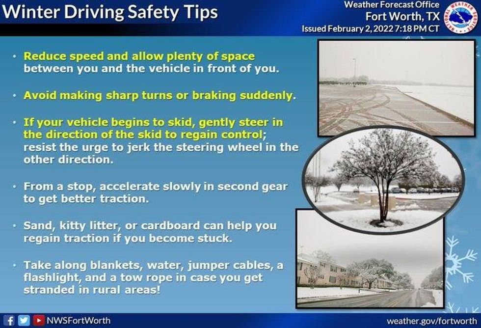 Tips for driving on slick roadsNational Weather Service
Another freeze is expected Monday morning with temperatures falling into the 20s. There will be many slick spots, but plenty of sunshine during the day should get rid of all the ice and snow. High temperatures will be in the upper 40s.
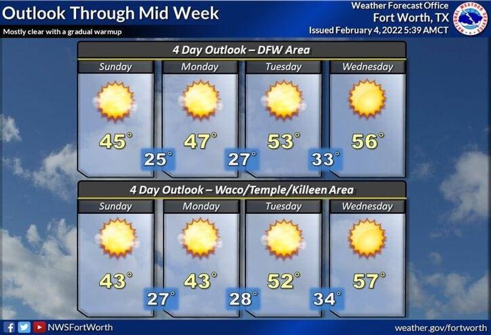
The warming trend will continue through the middle of next week, as temperatures get back to seasonable levels in the mid to
upper 50s.
Please remember to drip your faucets through late Saturday morning and please stay at home if at all possible.
7-Day Headlines:
* High Thursday: 31 degrees at DFW.
* Record snowfall and sleet Thursday (1.7", old rec. 0.2" in 2011)
* Staying below freezing Friday, late day sun.
* Hard Freeze Warning Friday.
* Freezing fog Saturday morning.
* Warming this weekend, but sub-freezing mornings.
* Ice is gone by Sunday afternoon.
_________________________________________________________
*Thursday rain: 0.29"; *Thursday high: 31; Low: 20
*Friday's averages: High: 59; Low: 38
*Record high: 82 (2008); Record low: 8 (1996)
________________________________________________________
*February rain: 1.10"; February surplus:
*2022 Rain: 1.39"; 2022 deficit
*Sunrise: 7:22am; Sunset: 6:04pm
 Four-day forecast for North and Central Texas on Friday, Feb. 4, 2022.National Weather Service
**Hard Freeze Warning Friday night through 9 a.m. Saturday**
Friday: Cloudy, breezy and continued VERY cold. High: Mid to upper 20s. Wind chills in the teens. Wind: NNW 10-20 mph.
Friday night: *Hard Freeze Warning* Clear and bone-chilling cold. Freezing Fog possibly developing. Low: 6-11. Wind: WNW 5 mph.
Saturday: *Record low is 12 degrees (1912)* - Morning freezing fog, clearing out late morning, then sunny and a little warmer. High: Low to mid 30s. Wind: Lt. Var.
Saturday night: Clear and VERY cold. Low: Mid to upper teens.
Sunday: Sunny and a bit warmer, but a COLD start. Road conditions improve after the noon hour. High: Low 40s.
Monday: Sunny and warmer. High: Mid to upper 40s.
Tuesday: Sunny and even warmer. High: Low to mid 50s.
Wednesday: Sunny and seasonable. High: Mid to upper 50s.
Thursday: Sunny, continued cool, but seasonable. High: Mid to upper 50s.
LISTEN on the Audacy App
Sign Up and Follow NewsRadio 1080 KRLD