


Rain is coming to an end, for now, but more on the way, especially early Sunday. After that, I think we're done for a while as we heat up next week, and endure a ton of humidity and mosquitoes the size of smart cars!
This week just blew on by and we've seen a ton of rain. Our rainfall surplus at DFW is now close to 8 and 1/2 in. Some areas have an even bigger surplus than that. Showers and storms continue to press out of North Texas this morning, however, there's some redevelopment off to the west of DFW. The Flood Watch has been allowed to expire early north of I20. These will mainly affect our western and southern counties through the morning and afternoon hours. There still may be a few storms around DFW, but the best chances will stay south and west. Highs will jump up in the low to mid-80s depending on sunshine.
 NWS
NWS
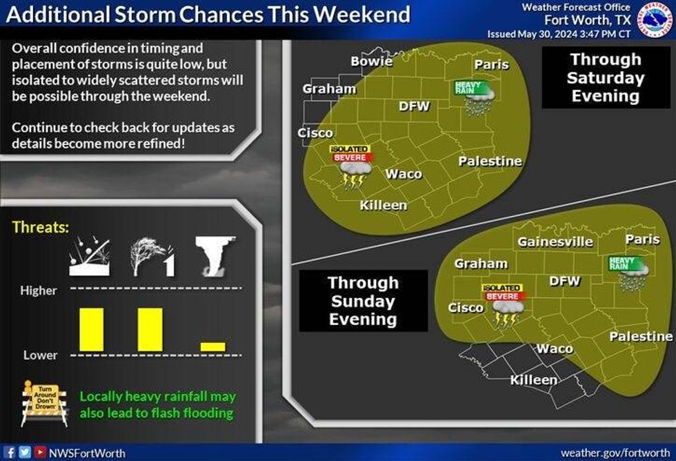
I don't see any storms forming west of us overnight tonight, so I'm going to keep Saturday mainly dry with only an isolated afternoon and evening shower or storm. High temperatures will reach the mid-80s.
Another complex of storms will form out in west Texas late Saturday evening. If these hold together, they will arrive here by daybreak on Sunday. Flooding may be a concern, but the severity will remain on the low side. Highs on Sunday will reach the mid 80s, maybe a little warmer west of DFW.
We start the dry out next week and heat up. Plenty of humidity with highs near 90 on Monday. Low 90s Tuesday through Thursday, as the humidity continues to mess one's hair up.
____________________
7-Day Headlines:
* DFW Airport reached 77 yesterday. 1.29" of rain.
* Rain coming to an end this morning.
* Decent weather the rest of today and most of Saturday.
* Storms chances return early Sunday morning.
* A slight storm chance early Monday.
* Dry, hot and humid next week.
_____________________________________________________
*Yest Rain: 1.29"; Yest High: 77; Low: 66
*Today's Averages: High: 88; Low: 69
*Record high: 103 (1911) Record low: 54 (1903, 1983, 1984)
__________________________________________________________
*May Rain: 7.24"; Surplus: 2.61"
*2024 Rain: 24.51"; Surplus: 8.07"
*Sunrise: 6:21am; Sunset: 8:31pm
_________________________________________________________
Today: Morning rain, afternoon sun. Flood Watch may expire early. High: Low to mid 80s. Wind:: South 5-10 mph.
Tonight: Mostly cloudy, with a few showers by morning. Low: Mid to upper 60s. Wind: SE 5-10 mph.
Tomorrow: Partly cloudy with a slight chance of showers and storms. High: Low to mid 80s.. Wind: SSW 5-10 mph.
Sunday: Morning showers and storms, then partly cloudy, warm and humid. High: Mid 80s.
Monday: A slight chance of morning showers and storms, then partly cloudy, warm and humid. High: Near 90.
Tuesday - Thursday: Partly cloudy, warm and humid. Highs: Low 90s.
LISTEN on the Audacy App
Tell your Smart Speaker to "PLAY 1080 KRLD"
Sign Up to receive our KRLD Insider Newsletter for more news
Follow us on Facebook | Twitter | Instagram | YouTube


