


Get ready for a very hot 3 days ahead! The average high temperature this time of the year is 82゚. Daytime highs today through Sunday will be in the low, possibly some mid nineties today and tomorrow.
Our record high for today and tomorrow is 96゚. We will come close, but I don't think we'll break it.
Very windy conditions will prevail today all the way through next Wednesday. Wind will gust from the southwest today up to 30 mph. Saturday and Sunday gusts to 25mph.
Morning lows will be very mild and muggy with readings on the upper sixties to mid seventies through the weekend.
Speaking of the weekend, Texas/OU Red River Classic starts at 11:00 a.m. tomorrow morning. Kick off temperature will be in the low eighties, end of the game temperature low nineties. Please make sure you dress appropriately and stay hydrated during the game. There is no shade to be found anywhere!
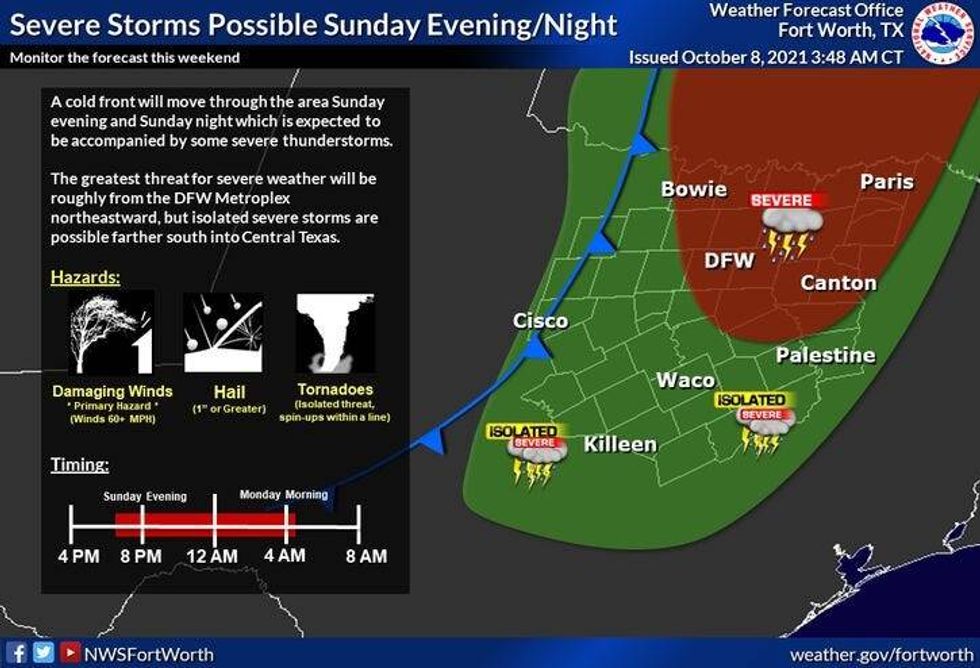
Now let's talk about the severe risk for Sunday evening. A level 2 and 3 out of 5 is in place across the northern and eastern parts of north Texas. As I stated above in my last post, I'm still not overly confident for severe weather west of interstate 35 and south of I 20. It still looks like the bulk of the severe weather will be just north and east of Dallas and Fort Worth, but I will keep an eye on things as usual and have updates throughout the weekend.
 NWS
NWS
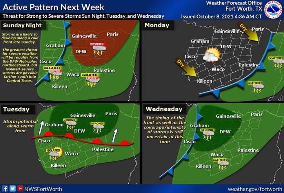
A weak cold front clears things out and dries the air out for Monday. It's still going to be warm with highs in the mid eighties. We get close to 90 on Tuesday with a few scattered storms possible and then a better chances for strong storms early Wednesday afternoon. Highs on Wednesday will be near 80, upper seventies for Thursday with very dry air in place.
 nws
nws
An even stronger front looks like it'll blow through here by the end of next week, dropping temperatures into the seventies for highs and morning lows in the upper forties to low fifties.
Please stay weather aware Sunday evening as will I. Updates throughout the weekend on KRLD and on FB on our possible severe weather threat!
________________________________________
7-Day Headlines:
* We hit 92 yesterday!
* A windy weekend ahead
* Unseasonable hot through early next week.
* Level 2 and 3 for severe storms late Sunday eveing.
* More storm chances Tuesday and Wednesday. Isolated severe.
__________________________________________________________
*Yest Rain: 0.00"; *Yest High: 92; Low: 62
*Today's Averages: High: 82; Low: 60
*Record high: 96 (1979); Record low: 39 (1921, 2012)
___________________________________________________________
*October rain: 0.58"; October deficit:
*2021 Rain: 27.67"; 2021 deficit:
*Sunrise: 7:27am; Sunset: 7:03pm
Today: Sunny, windy and hot. High: Near low to mid 90s. Wind: South 10-20, G30 mph.
Tonight: Increasing clouds, breezy, mild and muggy. Low: Low to mid 70s. Wind: South 10-20 mph.
Tomorrow: Morning clouds, afternoon sun. Sunny, windy and hot. High: Low to mid 90s. Wind: South 15-25 mph.
Sunday: Partly cloudy, windy and hot. Chance of scattered severe storms towards late evening. Level 2 and 3 out of five for hail and wind. High: Near 90.
Monday: Mostly sunny, windy, less humidity. High: Mid to upper 80s.
Tuesday: Partly cloudy, windy and warm. Slight chance of showers and storms. High: Upper 80s.
Wednesday: Partly cloudy and a bit cooler. Better chance of showers and storms. High: near 80.
Thursday. Mostly sunny and pleasant. High: Upper 80s.
LISTEN on the Audacy App
Sign Up and Follow NewsRadio 1080 KRLD


