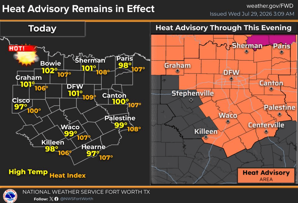
Heat Advisories remain in effect today and Thursday and will likely extend into Friday, which is expected to be the hottest day of the week. After that, we'll enjoy a brief cool-down this weekend. If you're lucky, you may even catch a passing shower early Saturday morning before the heat quickly builds back into North Texas next week as August begins on Saturday.
Good morning! I hope everyone had a great Tuesday.
We're waking up to temperatures ranging from 75 to 80 degrees once again this morning. Winds are light, radar is quiet, and you'll have a dry commute to work. A strong upper-level ridge of high pressure continues to dominate our weather pattern, so I don't expect any rainfall through Friday evening.
Yesterday, DFW reached 100 degrees, marking our 8th triple-digit day of the year. We'll climb to around 101 today, 103 on Thursday, and as hot as 105 on Friday. Heat Advisories will likely continue, and it's possible parts of North Texas could briefly be upgraded to an Extreme Heat Warning on Friday as heat index values approach 110 degrees.
A cold front will move through the area late Friday night while most of us are sleeping. Unfortunately, it won't bring 30-degree temperatures Saturday morning—I wish! But it will deliver a refreshing north wind at 10-20 mph and knock afternoon highs back to around 99 degrees.
The cooler air lags behind the front, so Sunday morning will start off in the low to mid-70s, with afternoon highs in the mid-90s. It'll feel noticeably more comfortable, and at this point, no Heat Advisories are expected this weekend or even into Monday.
By Tuesday and Wednesday of next week, temperatures climb right back into the lower 100s as the upper-level ridge briefly shifts west this weekend before expanding back across Texas.
I hope everyone has a great day today, and remember to enjoy the weather when you can—it's the only weather you've got!
7-Day Headlines:
- DFW Airport hit 100 degrees on Tuesday
- 8 triple digit temperatures this summer
- Heat Advisory today and Thursday. Heat Warning Friday?
- Heat index values 105+ degrees
- Friday night cold front. Slight rain chance
- 90s this weekend! Low humidity!
- Heating up next week
- Download our AUDACY app! Listen to KRLD LIVE at home or at work
Almanac:
- Yest Rain: 0.00”; Yest High: 100; Low: 80
- Today’s Averages: High: 97; Low: 77
- Record high: 109 (1912); Record low 67 (1984)
- July rain: 1.36”; Deficit: <0.56”>
- 2026 Rain: 22.61”; Snow: 2.4”; Surplus: 0.40”
- Sunrise: 6:40am; Sunset: 8:28pm
Forecast:
Wednesday: **Heat Advisory** Mostly sunny and hot. High: 101. Heat index: 105+. Wind: South 5-10 mph.
Wednesday night: Clear, warm and muggy. Low: Near 80. Wind: South 5-10 mph.
Thursday: **Heat Advisory** Partly cloudy and hot. High: 103. Heat index: 105+ Wind: South 5-10 mph.
Friday: ** Heat Advisories or Warnings likely** Partly cloudy and very hot. Near record highs (106 degrees). Late evening cold front. A few isolated showers. High: 105. Heat index: Near 110.
Saturday: Partly cloudy, A bit cooler. Lower humidity. High: Upper 90s.
Sunday: Sunny and pleasant? Low humidity continues.A brief-break from the triple digit heat. High: Mid 90s.
Monday: Sunny and warmer. High: Upper 90s.
Tuesday: Sunny and hot. High: Near 100.
LISTEN on the Audacy App
Tell your Smart Speaker to "PLAY 1080 KRLD"
Sign Up to receive our KRLD Insider Newsletter for more news
Follow us on Facebook | Twitter | Instagram | YouTube