


We reached 103° yesterday at DFW Airport, marking our fifth triple-digit temperature this summer. Currently, temperatures are expected to be slightly below 100 today through the weekend, with isolated showers and storms possible today and tomorrow. A weather change is anticipated early next week, bringing another cold front into north Texas and the potential rain chances.
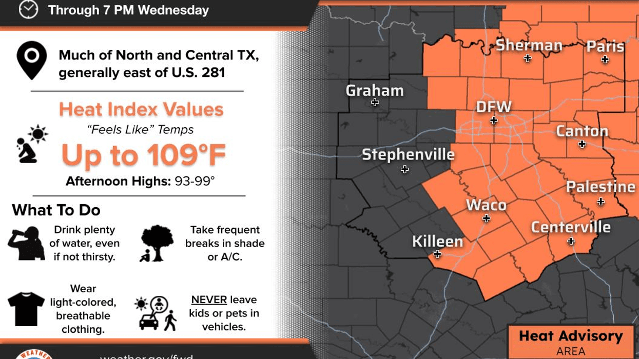
Good morning and welcome to Wednesday. Temperatures are currently in the upper 70s to low 80s under partly cloudy skies. A complex of storms is moving out of Oklahoma, heading south-southwest, and will impact western North Texas this morning. Residents west of Interstate 35 and 35W have a higher chance of storms. East of Fort Worth, little to no precipitation is expected. We await the interaction between the frontal boundary and daytime heating later this afternoon and evening. Some areas will experience rain, while others will not, with the highest chance along and south of Interstate 20. Afternoon highs will reach the mid to upper 90s, with heat index values nearing 105°.
A similar forecast is expected for tomorrow, with partly cloudy conditions and highs in the mid to upper 90s. Isolated late-day showers and storms are possible, primarily south of Interstate 20.
The weekend is expected to be mainly dry, with partly cloudy skies and afternoon highs in the mid to upper 90s. Heat index values will approach 105°.
A significant cooldown is anticipated for the eastern United States next week, with a rare late August cold front moving into the area on Monday, producing scattered showers and storms. Afternoon highs will reach the low 90s, followed by seasonally cool weather on Tuesday, with highs in the low to mid 80s. Additional scattered showers and storms are possible. Further updates will be provided as the weekend approaches.
Have a great day, and enjoy the weather when you can, it's the only weather you've got!
7-Day Headlines:
* DFW Airport reached 103 on Tuesday.
* Heat Advisories today! Heat indicies near 105 degrees.
* Isolated late-day showers and storms Wednesday and Thursday.
* Drying out Friday - Sunday.
* Temperatures mid to upper 90s.
*Another cold front next Monday and Tuesday may bring more rain!
*Yest Rain: 0.00"; Yest High: 103; Low: 80
*Today's Averages: High: 96; Low: 76
*Record high: 109 (2023); Record low: 58 (1940)
*August Rain: 1.34"; Surplus: 0.17"
*2025 Rain: 23.50"; Deficit: 0.04"
*Sunrise: 6:56am; Sunset: 8:06pm
Wednesday: ** Heat Advisories and Poor Air Quality Alert ** Partly cloudy and hot. Isolated storms. Threats: Frequent lighting, downburst wind, heavy rain. High: Upper 90s. Heat index: Near 105 degrees. Wind: ENE 5-10 mph.
Wednesday night: Partly cloudy and muggy. An evening storm. Low: Mid to upper 70s. Wind: NE 5 mph.
Thursday: Partly to mostly cloudy, warm and humid. Isolated showers and storms. Threats: Frequent lightning, gust wind, heavy rain in area. High: Mid to upper 90s.
Friday - Sunday: Partly cloudy, hot and humid. HIghs: Mid to upper 90s.
Monday: Partly cloudy, warm and humid. Another cold front. Chance of showers and storms return. High: Low 90s.
Tuesday: Partly cloudy and MUCH cooler. Scattered showers and storms. High: Low to mid 80s!!
LISTEN on the Audacy App
Tell your Smart Speaker to "PLAY 1080 KRLD"
Sign Up to receive our KRLD Insider Newsletter for more news
Follow us on Facebook | Twitter | Instagram | YouTube


