There is not much going on in the world of weather here across north Texas through the rest of the month as Heat Advisories will be in place through the weekend.
This is when the surface temperature or feels like temperature reaches 105+. We do have a few things in our favor, July is almost over and the humidity levels will be low during the afternoon hours. This will alleviate the heat index values through the weekend as well.
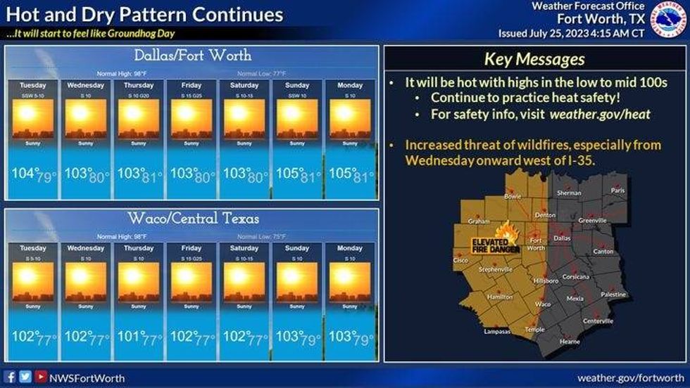
We're starting Tuesday with temperatures in the upper 70s to low 80s this morning with not a cloud in the sky. Plenty of sunshine and hot today with a high near 104° at DFW Airport. A few degrees hotter to the west, a couple of degrees cooler to the east.
 National Weather Service - Fort Worth
That will be our weather story through Saturday. We might even be a couple degrees hotter than that this Sunday into early next week.
Pattern change? That may arrive by the middle of next week as his ridge of high pressure breaks down and I might introduce rain back in the forecast. Please keep in mind this is day 9 and 10 in the extended forecast and is subject to change.
 National Weather Service - Fort Worth
*Yest Rain: 0.00"; Yest High: 102 Low: 76
*Today's Averages: High: 97; Low: 77
*Record high: 109 (1954): Record low: 65 (1915)
*July Rain: 0.47"; Deficit: 1.28
*2023 Rain: 14.83"; Deficit: 7.21
*Sunrise: 6:376am; Sunset: 8:32pm
Today: *Heat Advisory* Sunny, breezy and hot. Grass fire danger. High: 104, hotter west of I-35W. Wind: South 10-20 mph.
Tonight: Clear and warm. Low: 78-82. Wind: South 10-15 mph.
Wednesday: *Heat Advisory* Sunny, berezy and hot. Grass fire danger. High: 104, hotter west of I-35W. Wind: South 10-20 mph.
Thursday - Friday: *Heat Advisory* Sunny and hot. Grass fire danger. High: 104, hotter west of I-35W. Wind: South 10-20 mph.
Saturday: Sunny and continued hot. High: 105.
Sunday: Sunny and continued hot. High: Near 105.

LISTEN on the Audacy App
Tell your Smart Speaker to "PLAY 1080 KRLD"
Sign Up to receive our KRLD Insider Newsletter for more news