North Texas will see two days of heat advisories, a brief cooldown, and a few lucky ones may see some showers this weekend. After that, the heat returns with a vengeance next week.
Wednesday began with temperatures in the 70s and low 80s with very little cloud cover overhead. Humidity levels were high but will drop off significantly during the afternoon. It will be the same story for Thursday as well. Heat advisories are back as temperatures today and tomorrow will range between 100-105 from east to west. The record for Wednesday is 106 degrees at DFW Airport.
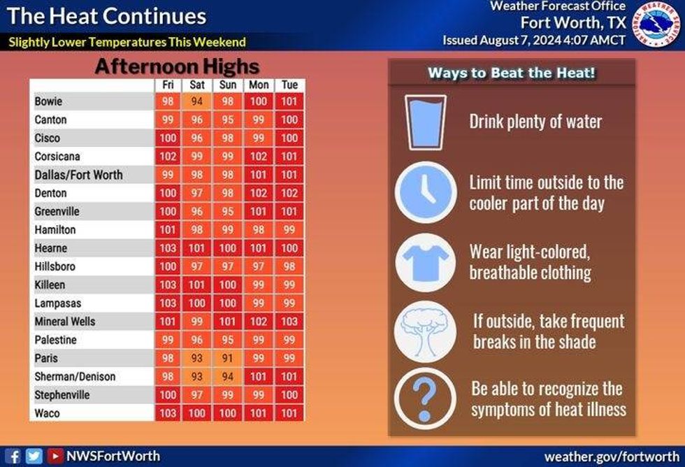
The next subtle weather change arrives on Friday as a cold front moves into the area. This will cause temperatures to be a bit cooler Friday through the weekend with afternoon highs in the 90s. The best rain chances look to be across the Texas panhandle, the Red River Valley, and into Oklahoma. Some of these showers and isolated storms may make it into the Dallas-Fort Worth area, especially during the morning hours on Saturday and Sunday. It all depends on the track of these disturbances and if the ridge of high pressure wins out, quashing any rain moving in from the northwest.
After this weekend, the front lifts to the north and high pressure dominates our weather all of next week. Temperatures will be back in the triple digits and heat advisories will return as well. Welcome to August ladies and gentlemen.
 High temperatures across Texas through TuesdayNational Weather Service
7-Day Headlines
* DFW Airport reached 101 on Tuesday, the 11th triple-digit day this summer.
* Heat Advisories Wednesday and Thursday, plus an Air Quality Alert is in effect.
* The record high today is 106 degrees. The forecast high is 104 degrees.
* Tropical Storm Debby is creeping off the South Carolina coast. Historic flooding continues.
* A weak cold front arrives here on Friday.
* Slightly cooler this weekend, with scattered showers and isolated storms.
* Heat returns through next week.
_____________________________________________________
*Tuesday Rain: 0.00"; Tuesday High:101; Low: 77
*Wednesday's Averages: High: 97; Low: 77
*Record high: 106 (1951, 1953, 1988); Record low: 61 (1997)
_______________________________________________________
*August Rain: 0.31"; Deficit:
*2024 Rain: 31.60"; Surplus: 8.88"
*Sunrise: 6:46am; Sunset: 8:21pm
________________________________________________________
Wednesday: *Heat Advisory and an Air Quality Alert today* Mostly sunny and hot. Low humidity in the afternoon. High: 100-105 (record 106). Heat index: 106-108. Wind: ENE 5 mph.
Wednesday night: Clear, mild, and muggy. Low: Near 80. Wind: South 5 mph.
Thursday: *Heat Advisory and an Air Quality Alert* Mostly sunny and hot. High: 100-105. Heat index: 106-108. Wind: Variable 5 mph.
Friday: Morning showers north of DFW. Increasing clouds and a bit cooler. Weak cold front. Scattered showers and storms late (best chance north of I-20). High: Mid to upper 90s.
Weekend: Mostly cloudy, a bit cooler. Scattered showers and storms. Not everyone will see rain. Highs: Low to mid-90s.
Monday: Morning showers, then partly cloudy and warm. High: Mid to upper 90s.
Tuesday: Mostly sunny and hot. High: 98-102.
LISTEN on the Audacy App
Tell your Smart Speaker to "PLAY 1080 KRLD"
Sign Up to receive our KRLD Insider Newsletter for more news
Follow us on Facebook | Twitter | Instagram | YouTube