North Texas has had 12 straight days with below-average temperatures. The average high temperature for this time of year is 97 degrees. After mid-August, temperatures will trend downward until September.
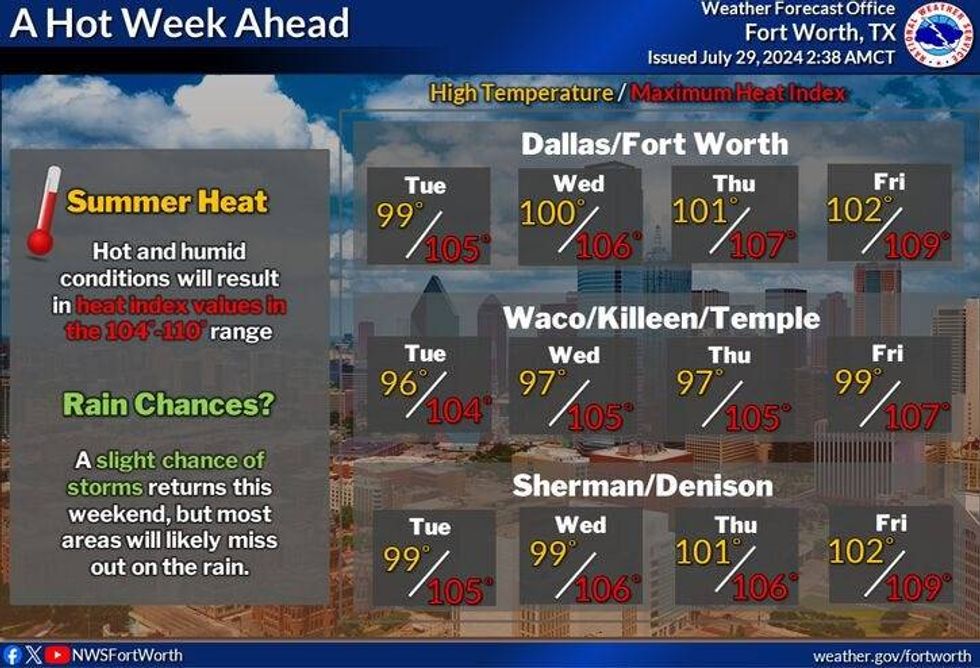
A strong upper-level area of high pressure will slowly nose its way toward North Texas this week. That means no rain, increasing temperatures, and more heat advisories. Afternoon highs on Monday will reach the mid to upper 90s, near 100 tomorrow, and 100-103 degrees Wednesday through Friday.
As the weekend nears, the ridge of high pressure may back off to the west a bit allowing a northerly flow to develop in the upper levels of the atmosphere. If it does, a weak cold front may settle into the area, producing some widely scattered late-day showers and storms. It will also be a few degrees cooler with highs in the upper 90s.
 North Texas forecast for July 30 through Aug. 2, 2024.National Weather Service
7-Day Headlines
* DFW Airport reached 92 on Sunday.
* Heat Advisory Monday and many more to come this week.
* Triple digits making a return this week. Feeling like 105 -109 degrees.
* Stay hydrated, frequent breaks, sunscreen, and a hat.
* No rain for a while.
* Tropics getting active again?
_____________________________________________________
*Sunday Rain: 0.00"; Sunday High: 92; Low: 74
*Monday's Averages: High: 97; Low: 77
*Record high: 106 (1974, 1986, 2017) Record low: 65 (1944)
_______________________________________________________
*July Rain: 2.55"; Surplus: 0.63"
*2024 Rain: 31.29"; Surplus: 9.08"
*Sunrise: 6:41am; Sunset: 8:28pm
_______________________________________________________
Monday: *Heat Advisory* Mostly sunny, breezy, hot and humid. High: Mid to upper 90s. Heat index near 105 Wind: SSW 15-25 mph.
Monday night: Partly cloudy, mild, and muggy. Low: Mid to upper 70s. Wind: South 15-25 mph.
Tuesday: Heat Advisories likely. Mostly sunny, breezy and hot. High: Near 100. Heat index: 105-109. Wind: South 15-25 mph.
Wednesday - Friday: Heat Advisories likely. Sunny, continued hot. High: 100 - 103. Heat index: 105-109.
Weekend: Partly cloudy and hot. A slight chance of afternoon showers and storms. Highs: 96-99.
LISTEN on the Audacy App
Tell your Smart Speaker to "PLAY 1080 KRLD"
Sign Up to receive our KRLD Insider Newsletter for more news
Follow us on Facebook | Twitter | Instagram | YouTube