North Texas Weather Update – Thursday Morning
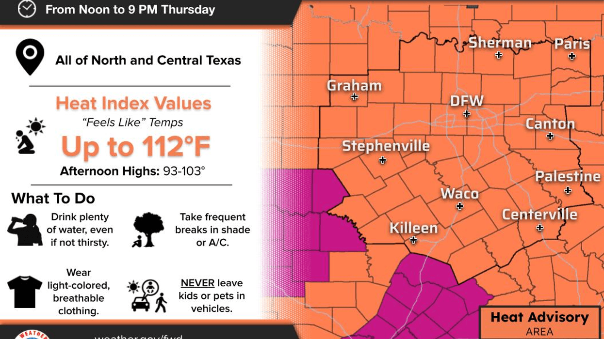
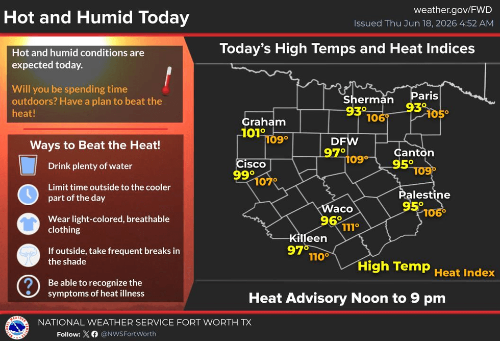
The first Heat Advisories of the late spring season have arrived across North Texas. These advisories go into effect at noon today and remain in effect until 9:00 p.m. Heat index values will soar above 105° during the peak heating hours of the afternoon.
That's the bad news.
The good news is that a significant weather change arrives tomorrow morning. Widespread showers and strong thunderstorms will move in from the northwest and should exit the area shortly before or just after noon. A much cooler day is ahead for Friday.
Good morning, everyone, and welcome to almost Friday!
We're waking up to temperatures in the mid to upper 70s under a partly cloudy sky. Plenty of sunshine today will allow very hot conditions to develop across the region. Heat Advisories will be in effect this afternoon through early evening as daytime highs range from 95° to 102°, with the hottest temperatures west of Interstate 35W.
Heat index values in many locations will climb above 105°.
Please stay hydrated and take frequent breaks if you're working outdoors. Wear light-colored, loose-fitting clothing, apply sunscreen, and wear a hat to help beat the heat. Also, remember to check the back seat for children and pets.
Speaking of pets, make sure they have a cool place to stay during the hottest part of the day. If they must be outside, ensure they have plenty of shade and a large bucket of fresh water.
Thankfully, this heat only sticks around for one day.
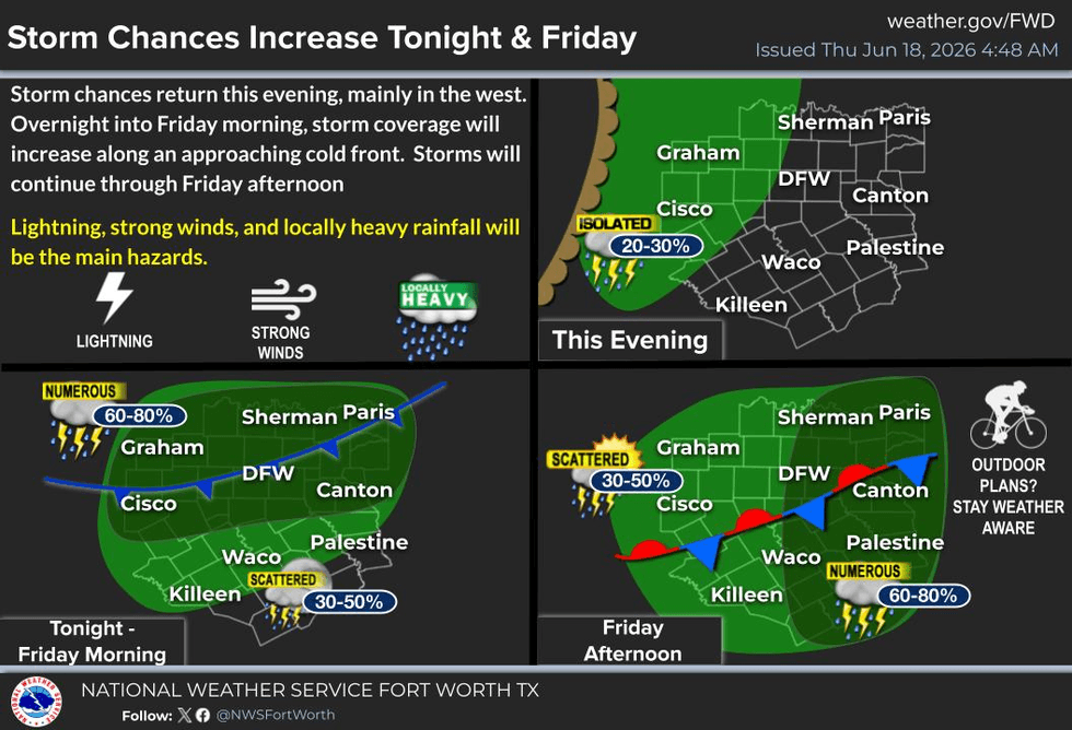
Our next weather maker arrives tomorrow morning as a cold front attempts to move through the area. Ahead of it, a large complex of showers and thunderstorms is expected to develop late this evening to our west and northwest before gradually moving across North Texas Friday morning.
A few storms could become severe, with damaging winds, small hail, frequent lightning, and heavy rainfall being the primary threats.
Tomorrow morning's commute will look much different than today's. The good news is that many people will be off for the Juneteenth holiday. If you do have to work, attend summer school, or travel Friday morning, allow extra time to reach your destination.
Because of the clouds and rain during the first half of the day, temperatures may struggle to get above 85°. Your weather apps may be showing highs in the mid to upper 90s.
Hogwash!
The weekend looks pretty darn good for a change. Saturday will feature partly cloudy skies with highs near 90°. Sunday will be warmer, with highs reaching the mid-90s and perhaps some upper 90s west of Interstate 35W. Combined with the humidity, heat index values will top 100° in some areas.
At this time, I do not expect Heat Advisories on the first day of summer or Father's Day, but it will certainly feel hot. Either way, I might recommend keeping those picnics indoors. LOL!
A typical late-June weather pattern sets up next week. High pressure aloft will remain west of Texas, placing North Texas in a northwest flow pattern. Cold fronts often try to move into the area in this setup but usually struggle to make much progress.
What frequently happens instead is that clusters of thunderstorms develop across eastern Colorado and western Kansas during the late afternoon and evening. These storms can organize into lines and occasionally survive the trip into North Texas before daybreak.
I'll be keeping a close eye on our northwest horizon Monday, Tuesday, and Wednesday mornings for that possibility. Afternoon highs through much of next week should remain in the lower 90s. Seasonable weather!!
I'll be watching!
Have a terrific day today, and please enjoy the weather when you can—it's the only weather you've got!
— Dan the Weatherman
7-Day Headlines:
* DFW Airport reached 94 on Wednesday
* Heat Advisory today. Heat index values 104-108 degrees. Stay hydrated!!
* Scattered showers and storms return Friday morning, ending after lunch
* Leftover showers and storms Friday afternoon and evening, mainly south and east of DFW
* A hot and humid weekend ahead
* Morning scattered showers and storms Monday through Wednesday
Almanac:
*Yest Rain: 0.00”; Yest High: 94; Low: 76
*Today’s Averages: High: 92; Low: 73
*Record high: 104 (1918, 2011); Record low 56 (1912)
*June rain: 7.40”; Surplus: 5.23”
*2026 Rain: 20.58”; Snow: 2.4” Surplus: 1.82”
*Sunrise: 6.20am; Sunset: 8:39pm
Forecast:
Thursday: *Heat Advisory noon -9pm* Partly cloudy, hot, humid and breezy. High: 95-102. Hottest temperatures west of I-35W. Heat index: 105-108. Wind: South 10-20 mph.
Thursday night: Increasing clouds. Showers and storms (some strong) moving in from the NW by daybreak. Mild and muggy. Low: Mid to upper 70s. Wind: South to north 5-10 mph.
Friday: Morning strong storms. Threats: Damaging wind, small hail, heavy rain, frequent lightning. Afternoon and evening string storms, mainly south and east of DFW. High: Mid 80s.
Saturday: Morning showers (east and south), becoming partly cloudy, warm and humid. High: Near 90. Heat index: Mid to upper 90s.
Sunday: partly cloudy, breezy, hot and humid. High: Mid 90s. Heat index low 100s.
Monday: Isolated morning storms, afternoon sun. Hot and humid. High: Mid 90s. Highs: Low to mid 90s.
Tuesday and Wednesday: Morning showers and storms, some afternoon sun. Warm and humid. Highs: Low 90s.
LISTEN on the Audacy App
Tell your Smart Speaker to "PLAY 1080 KRLD"
Sign Up to receive our KRLD Insider Newsletter for more news
Follow us on Facebook | Twitter | Instagram | YouTube