


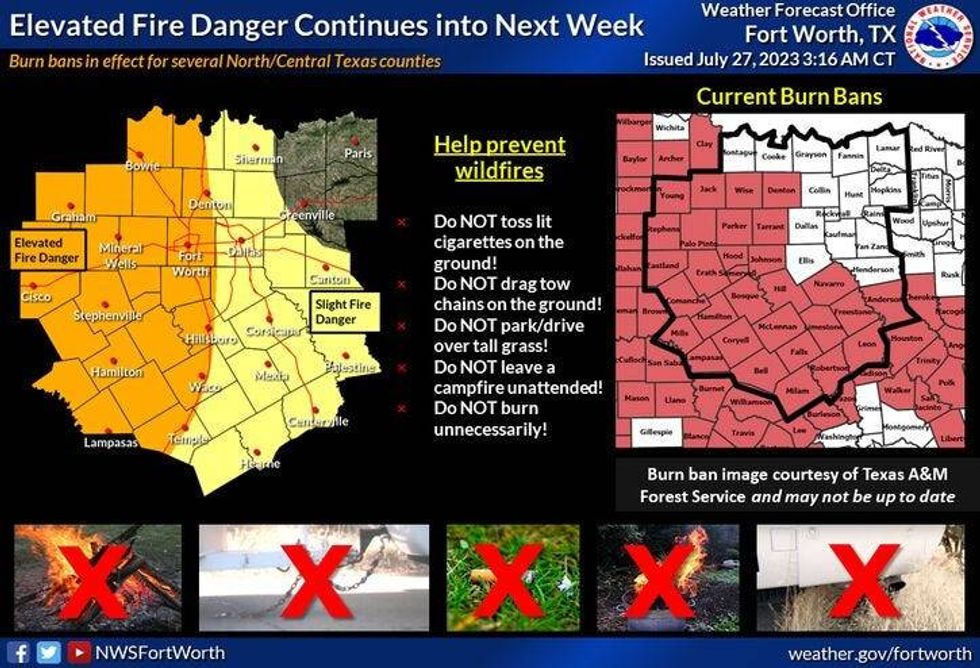
July is almost over, but we still have August to tend with. We've had 18 triple-digit days so far in 2023, 20 is average and there are many more to come.
A large dome of high pressure will strengthen over North Texas and will build into the heartland of America this weekend, with the hottest temperatures into the plains states. Unfortunately, this ridge will really strengthen over North Texas next week. We'll be flirting with record highs Sunday, Monday and Tuesday. No rain is in the forecast until possibly next weekend.
 National Weather Service - Fort Worth
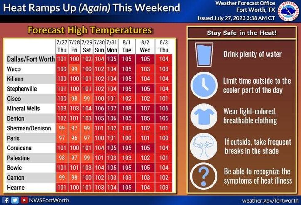
Thursday stars off with temperatures in the mid 70s to low 80s at this hour under a clear sky. Plenty of sunshine today and tomorrow, with Heat Advisories in effect for most of us. Afternoon highs will top out around 102° at DFW, hotter to the west. More of the same this weekend as we slowly start the heat up. 103° on Saturday, 105° on Sunday (record 106) and 107° on Monday (record 106) and Tuesday (record 107). Wednesday we cool down to 106°.
The relentless heat will continue next Thursday and Friday before a cold front enters the picture. Slightly cooler weather is in the forecast for next weekend with a chance of rain as well.
 National Weather Service - Fort Worth
*Yest Rain: 0.00"; Yest High: 102 Low: 81
*Today's Averages: High: 97; Low: 77
*Record high: 106 (1944): Record low: 65 (2020)
*July Rain: 0.47"; Deficit: 1.36
*2023 Rain: 14.83"; Deficit: 7.29
*Sunrise: 6:38am; Sunset: 8:31pm
Today: *Heat Advisory* Sunny, breezy and hot. Grass fire danger. High: 102, hotter west of I-35W. Wind: South 10-20 mph.
Tonight: Clear and warm. Low: 78-82. Wind: South 10-15 mph.
Friday: * Possible Heat Advisory* Sunny, breezy and hot. Grass fire danger. High: 102, hotter west of I-35W. Wind: South 10-20 mph.
Saturday: *Possible Heat Advisories* Sunny and hot. Grass fire danger. High: 103, hotter west of I-35W. Wind: South 10-20 mph.
Sunday: *Possible Heat Advisories* Sunny and hotter. Grass fire danger. Near (record 106) heat. High: 105, hotter west of I-35W.
Monday and Tuesday: Sunny, near (records 106, 107) heat. High: 107.
Wednesday: More of the same. Sunny and blistering hot. High: 106.
LISTEN on the Audacy App
Tell your Smart Speaker to "PLAY 1080 KRLD"
Sign Up to receive our KRLD Insider Newsletter for more news


