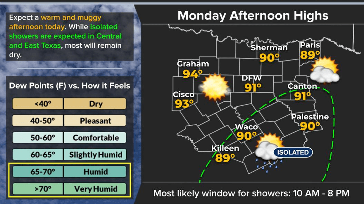
It's finally time to dry out across North Texas this week, although a few isolated showers may try to sneak in from the south today and from the west-southwest tomorrow. Most of the activity tomorrow should remain west of I-35W.
The big story continues to be the record rainfall we received yesterday. More than 3.5 inches of rain fell at DFW Airport, breaking the old daily record of 3.33 inches that was set back in 1989. We've now built up a rainfall surplus of more than 6 inches for the month of June, and it's only the 8th day of the month. It's also the first time in several months that DFW Airport has been running a surplus in rainfall, now sitting more than 2 inches above average. That's great news as we head into some of our climatologically driest months of the year.
The weather story this week will be the return of summer heat. High temperatures will climb into the low to mid-90s today and remain there through at least Friday. Heat index values should generally top out around 100 to 103 degrees each afternoon. Heat advisories typically require heat index values of 105 degrees or higher for at least two consecutive days, and at this point it appears we'll stay just below that threshold.
Rain chances will be very limited Wednesday through Friday, with mostly dry conditions expected.
Looking ahead to the weekend, a cold front will attempt to slide south out of Oklahoma. Thunderstorms are expected to develop across Oklahoma during the afternoon and evening hours, and a few of those storms could drift into our northern counties late each day.
Rain chances do increase somewhat for the weekend, which would make it 8 out of the last 10 weekends with measurable rain on at least one day. Even with those rain chances, temperatures should remain in the lower 90s.
That's a look at your weather. Have a great day, enjoy the sunshine while it's here, and make the most of the weather you've got!
7-Day Headlines:
- DFW Airport hit 93 degrees on Sunday; 3.55” (Record) at DFW
- 6.22” surplus for June; 2.81” surplus for the year; 9th wettest June!
- Slight chance of late day showers Monday and Tuesday
- Low to mid 90s all week; Heat index near 103 degrees
- Scattered storms Thursday - Saturday (especially northern counties)
- Increasing storm chances late Sunday into next Monday
- Mosquitoes and humidity dominate
- Download our AUDACY app. Listen to KRLD at home
Almanac:
- Yest Rain: 3.55”; Yest High: 93; Low: 70
- Today’s Averages: High: 90; Low: 71
- Record high: 100 (1911,1948); Record low 58 (1916)
- June rain: 7.16”; Surplus: 6.22”
- 2026 Rain: 20.34”; Snow: 2.4”; Surplus: 2.81”
- Sunrise: 6:19am; Sunset: 8:36pm
Forecast:
Monday: Morning clouds, afternoon sun. Isolated late-day showers (south of I-20). High: Low to mid 90s. Heat index:103 degrees. Wind: South 10-20 mph.
Monday night: Mostly cloudy and humid. Low: Mid 70s. Wind: South 10-20 mph.
Tuesday: Morning clouds, afternoon sun. Isolated late-day showers (west). High: Low to mid 90s. Heat index:103 degrees. Wind: South 10-20 mph.
Wednesday: Mostly sunny, hot and humid. High: Low to mid 90s. Heat index:103 degrees.
Thursday: Partly cloudy, hot and humid. High: Low to mid 90s. Heat index:103 degrees.
Friday: Morning showers and storms, afternoon sun. Hot and humid. High: Low to mid 90s.
Saturday: Partly cloudy, hot and humid. High: Low to mid 90s. Heat index:103 degrees.
Sunday: Morning showers and storms. Partly cloudy, hot and humid. Scattered storms .
LISTEN on the Audacy App
Tell your Smart Speaker to "PLAY 1080 KRLD"
Sign Up to receive our KRLD Insider Newsletter for more news
Follow us on Facebook | Twitter | Instagram | YouTube