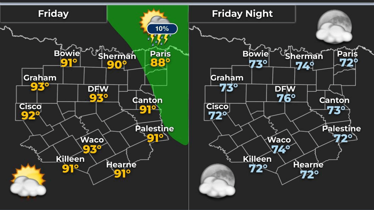

Storms are gone and it looks like we’ll be rain-free through the entire weekend as temperatures heat up into the 90s. But by next Tuesday through the rest of next week, scattered showers and storms are back in the forecast with slightly cooler temperatures.
Good morning everyone and welcome to Friday! It’s going to be a nice weekend as temperatures continue to rise while a bubble of high pressure builds across the area for the next 4 days or so. This will help push temperatures to some of the warmest readings we’ve felt so far this late spring. Hurricane season officially starts Monday, but I’m not expecting anything to develop in the Gulf anytime soon.
We’re waking up to temperatures near 70° this morning with the usual humidity around the area. Low clouds are not expected because winds have remained very light from the south. Those light winds combined with high pressure aloft will likely lead to poor air quality today and tomorrow. Winds should increase a bit early next week and help improve conditions somewhat.
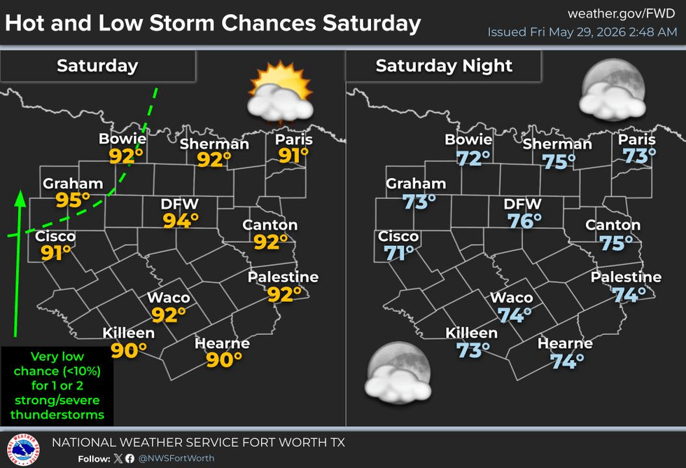
High temperatures will climb into the low 90s across the Dallas-Fort Worth area through the weekend, with mid to upper 90s possible west of Fort Worth and Denton. If you’re working outdoors, make sure to take frequent breaks, drink plenty of water, and keep pets indoors during peak heating hours.
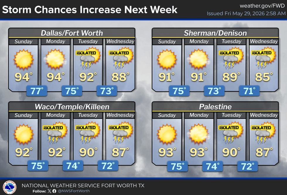
Next week the pattern begins to shift as the high pressure ridge flattens out. Weak disturbances moving in from the southwest beginning Tuesday, combined with plenty of moisture and daytime heating, will bring scattered showers and storms back into the forecast across much of North Texas and much of the state overall. This is great news for drought conditions outside of North Texas.
It’s not going to rain all day every day, but rain chances currently sit around 30–40% Tuesday through Friday of next week.
Have a great Friday, enjoy your weekend, and enjoy the weather when you can — it’s the only weather you’ve got!
7-Day Headlines:
- DFW Airport hit 88 degrees on Thursday. Officially: Trace of rain at DFW
- A hot, humid, and dry weekend ahead
- Heat index values near 100 degrees
- Scattered showers and storms return Tuesday through Thursday
- Threats: Heavy rain, lightning, gusty wind, small hail
- Cooler temperatures return
- Download our AUDACY app. Listen to KRLD at home
Almanac:
- Yest Rain: 0.00”; Yest High: 88; Low: 69
- Today’s Averages: High: 88; Low: 69
- Record high: 99 (1916, 1951); Record low 46 (1947)
- May rain: 2.96”; Deficit: <01.37”>
- 2026 Rain: 13.18”; Snow: 2.4” Deficit: <2.96”>
- Sunrise: 6:21am; Sunset: 8:30pm
Forecast:
Friday: *Air Quality Alert* Partly cloudy, warm and humid. High: Near 90. Wind: South 5-10 mph.
Friday: Decaying evening storms west of Hwy 281. Partly cloudy and humid. Low: Low 70s. Wind: South 5 mph.
Weekend: *Air Quality Alert* Partly cloudy, warm and humid. Highs: Low to mid 90s. Heat index near 100 degrees. WInd: South 10-15 mph.
Monday: Partly cloudy, warm and humid. High: Low to mid 90s
Tuesday - Thursday: Partly cloudy, warm and humid. Scattered showers and storms. Highs: 85-90.
LISTEN on the Audacy App
Tell your Smart Speaker to "PLAY 1080 KRLD"
Sign Up to receive our KRLD Insider Newsletter for more news
Follow us on Facebook | Twitter | Instagram | YouTube