Two bouts of thunderstorms.. one the second half of Tuesday and another the second half of Thursday. I can't rule out a few of these becoming strong or even severe with gusty wind and small hail being the threats. After these two systems, the upcoming weekend looks nice. Also we'll be dealing with above-average temperatures through the period.
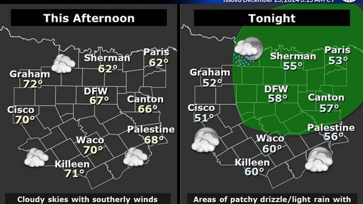
We're waking up to an overcast sky and very mild temperatures for this time of the year. Readings have only fallen into the low to mid-50s. A few breaks in the clouds today are expected with afternoon highs in the low to mid 60s.
Cloud ceilings lower tonight and I can't roll out a few scattered showers by daybreak tomorrow, especially along and east of Interstate 35. Morning lows will be very mild with readings only dipping into the mid to upper 50s.
 NWS
NWS
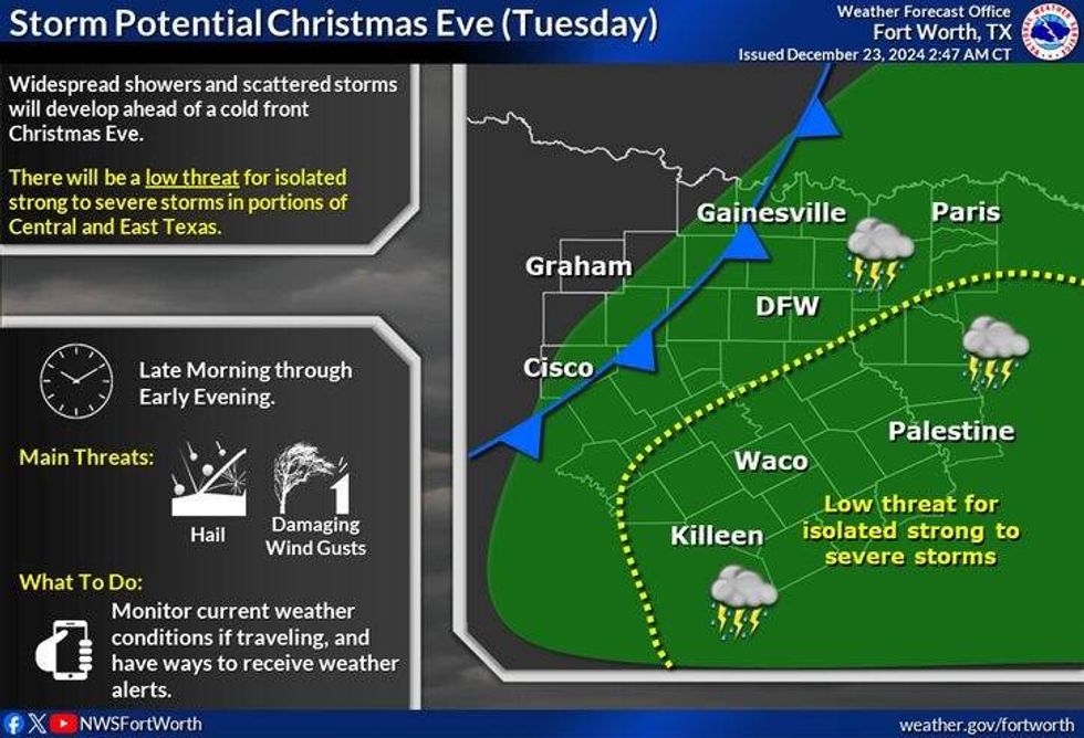
Grab your umbrella out the door tomorrow for Christmas Eve Day. Scattered showers and thunderstorms will develop during the afternoon and slide SE through the evening hours. We do have a marginal risk for severe weather just southeast of the Dallas-Fort Worth area. Gusty wind and small hail will be the threats. Everything should be out of our area by mid evening. Afternoon highs will reach the mid 60s. If you're heading south or east of the Dallas-Fort Worth area, try to head out before noon.
Christmas day looks uneventful as far as the weather goes, with a lot of cloud cover overhead. Afternoon highs will top out in the low 60s.
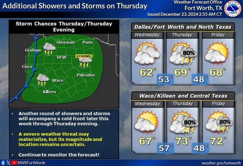
Our next weather system will move in quickly on Thursday. We've got another chance for showers and storms. A few may be strong the second half of Thursday into Friday morning. The threats: Small hail and gusty wind ,as well as dangerous cloud the ground lightning and some heavy rain in areas. Afternoon highs will remain very mild for this time of the year with highs in the mid to upper 60s.
 NWS
NWS
There will be some leftover shower and thunderstorm activity southeast of Dallas and Fort Worth on Friday. I think we'll have some breaks in the clouds with afternoon highs still very mild for this time of the year, upper 60s.
As of now, the weekend looks a-okay. Partly cloudy on Saturday with highs in the upper 60s. Mostly sunny Sunday with highs in the upper 60s. After that, things start to change with cold air moving in for the end of the year. It's still way too early if we'll see any precipitation over-running this much colder air mass that will be moving in slowly through next week. Stay tuned for updates as we get closer.
Have a terrific day today, please travel safely, and enjoy the weather when you can, it's the only weather you've got!
_______________________________
7-Day Headlines:
* DFW Airport reached 63 yesterday.
* A mostly cloudy and cool day today.
* Scattered showers and storms on Tuesday. A few will be strong.
* A mostly cloudy and cool Christmas and Hanukkah day.
* Rain returns Thursday.
* A decent weekend ahead.
_____________________________________________________
*Yest Rain: 0.00"; Yest High: 63; Low: 38
*Today's Averages: High: 56; Low: 37
*Record high: 81 (1955, 1964); Record low: -1 (1989)
__________________________________________________________
*December Rain: 2.61"; Surplus: 0.60"
*2024 Rain: 38.36"; Surplus: 2.18"
*Sunrise: 7:28am; Sunset: 5:27pm
__________________________________________________________
Today: Mostly cloudy, breezy, and cool. High: Low to mid 60s. South 15-25 mph.
Tonight: Cloudy, breezy and mild. Low: Upper 50s. Wind: SE 10-15 mph.
Tomorrow: Cloudy and mild. Morning showers, then scattered afternoon and evening showers and storms. A few may be strong. Threats: Gusty wind and small hail. High: Low to mid 60s. Wind: NW 5-10 mph.
Christmas/Hanukkah: Mostly to partly cloudy and cool. High: Low 60s.
Thursday: Mostly cloudy and mild. Scattered showers and storms return. A few may be strong. High: Upper 60s.
Friday: Partly cloudy and mild. A fews showers and storms SE of DFW. High: Upper 60s.
Weekend: Partly to mostly sunny and continued mild. Highs: Mid to upper 60s.
LISTEN on the Audacy App
Tell your Smart Speaker to "PLAY 1080 KRLD"
Sign Up to receive our KRLD Insider Newsletter for more news
Follow us on Facebook | Twitter | Instagram | YouTube