Monday begins with temperatures in the upper sixties to low seventies under a partly cloudy sky. Partly cloudy, humid and hot today with highs near 90゚. Heat index values will be in the mid to upper 90s. Please stay cool and hydrated.
There will be some storms in a weakened state approaching from the west this evening, similar to what happened yesterday evening, but most of you will stay dry. Morning lows will drop to near seventy degrees.
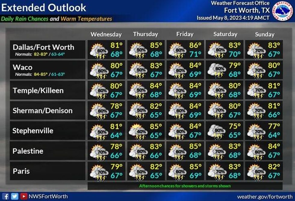
Tomorrow will be partly cloudy, warm and humid with highs in the mid two upper eighties. An upper level disturbance will be approaching from the south by late evening promoting widespread rain across central Texas.
This upper level low will slowly track across north and east Texas during the day Wednesday, bringing a pretty good shot of showers and storms across much of north Texas. Afternoon highs may not get above 80 degrees due to the clouds and rain around. Rainfall coverage will be at sixty percent.
 National Weather Service - Fort Worth
More scattered storms are in the forecast mainly during the afternoon and evening hours on Thursday and Friday with highs in the mid eighties. Severity will be low.
As of now, this weekend looks pretty messy with a good chance for showers and storms. Some rain could be heavy at times, depending on the speed and track of the next upper level low. Afternoon highs will only be near 80゚. Stay tuned on this forecast because it's Mother's Day weekend.
*Yest Rain: 0.00"; Yest High: 88 Low: 68
*Today's Averages: High: 81; Low: 62
*Record high: 95 (1933): Record low: 44 (1938)
*May Rain: 0.19"; Deficit: 0.86"
*2023 Rain: 11.42"; Deficit: 1.44"
*Sunrise: 6:35am; Sunset: 8:15pm
Today: Morning clouds, afternoon sun. VERY humid and HOT! Isolated late evening storms, mainly west of I-35W. High: Near 90. Heat index: Mid 90s. Wind: South 10-20 mph.
Tonight: Storms weaken to our west by midnight, then cloudy, breezy and humid. Low: 68-72. Wind: South 10-20 mph.
Tomorrow: Morning clouds, some afternoon sun. VERY humid and warm. Scattered evening storms, especially south of DFW. High: Upper 80s. Wind: South 5-10 mph.
Wednesday: Mostly cloudy and humid. Scattered showers and storms. Rain could be heavy at times. High: Near 80.
Thursday and Friday: Mostly to partly cloudy, warm and humid. Scattered late afternoon and evening storms. Highs: Mid 80s.
Weekend: Mostly cloudy, not as warm. Numerous showers and storms. Rain could be heavy at times. Highs: Near 80.

LISTEN on the Audacy App
Tell your Smart Speaker to "PLAY 1080 KRLD"
Sign Up to receive our KRLD Insider Newsletter for more news