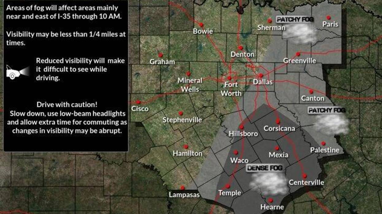
We're waking up to temperatures in the 50s with fog starting to develop across the area. The worst of it right now is along the Red River and areas south and east of DFW, where visibilities have dropped to less than a 1/2 a mile. Visibility at 5:30 this morning ranges between 4 to 6 miles across the immediate DFW area. This fog will lift after 9:00 a.m.
No rain is expected today through most of Friday, with above average temperatures. Morning clouds and afternoon sunshine will be the rule. Afternoon highs will reach the mid to upper 70s with a south wind picking up tomorrow and Thursday gusting to 30 mph.
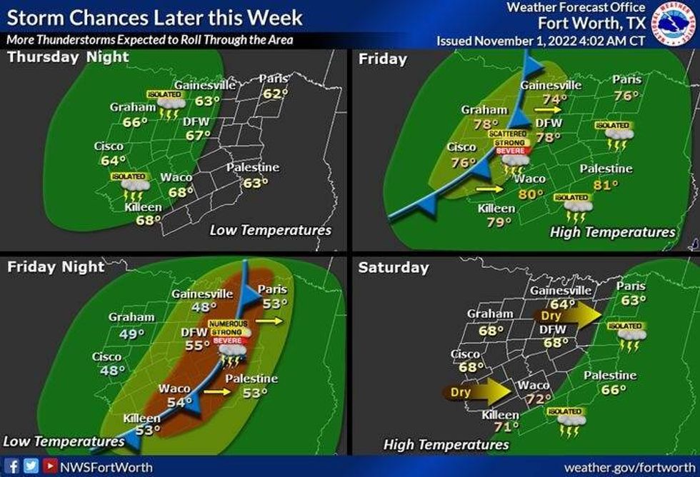
Late Friday afternoon and evening is the time frame to be weather aware. A strong upper level area of low pressure, a Pacific cold front and daytime heating will join hands to produce areas of strong to severe thunderstorms between 4:00 p.m. and midnight Friday.
 National Weather Service - Fort Worth
Hail, wind and isolated tornadoes will be the threats. In a scenario like this, it's the first 3 hours between 4:00 p.m. and 7:00 p.m. that need to be monitored for the larger hail and isolated tornadoes. If I were to draw a line right now for this, it would be areas along and northwest of a Gainesville to Decatur to Weatherford line. These are areas northwest of DFW. After the supercell threat goes away, a line of showers and storms will plow through here between 8:00 p.m. and midnight. Smaller hail, damaging wind, and brief spin-ups will be the threats. I will continue to tweet the timing of this Fall severe weather event tomorrow and especially on Friday. Stay tuned.
The system will be well to the east of us when you wake up Saturday morning, with a slow decrease in clouds. Afternoon highs will be cooler.. upper 60s.
This slightly cooler air mass will rapidly warm up Sunday through Tuesday, low 70s with sunshine Sunday, mid to upper 70s Monday and Tuesday.
*Yest Rain: 0.00"; High: 78; Low: 56
*Today's Averages: High: 72; Low: 51
*Record high: 94 (1991); Record low: 28 (1991)
*November rain: 0.00"; Deficit: 0.12"
*2022 Rain: 27.85"; 2022 deficit: 3.91"
*Sunrise: 7:46am; Sunset: 6:36pm
Today: Morning fog, afternoon sun. Mild. High: Mid to upper 70s. Wind: SSE 10-15 mph.
Tonight: Increasing clouds, mild and muggy. Low: Low to mid 60s. Wind: SSE 10-15 mph.
Thursday: Morning clouds, afternoon sun. High: Upper 70s. Wind: South 20-30 mph.
Friday: Increasing clouds, warm and windy. Late afternoon and evening showers and storms. Some severe. Threats: Damaging wind, pocket change size hail, and isolated tornadoes. High: Mid to upper 70s.
Saturday: Morning showers, then decreasing clouds, windy and a bit cooler. High: Mid to upper 60s.
Sunday: Mostly sunny, windy and seasonable. High: Low 70s.
Monday and Tuesday: Mostly sunny, breezy and mild. High: Mid to upper 70s.
LISTEN on the Audacy App
Tell your Smart Speaker to "PLAY 1080 KRLD"
Sign Up and Follow NewsRadio 1080 KRLD