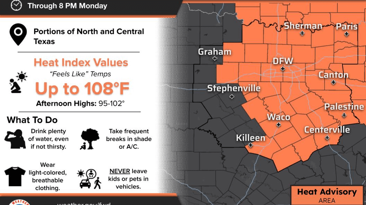

Triple-digit heat is finally making its way back to North Texas this week, and to add salt to the wound, Heat Advisories begin today and are expected to continue for the foreseeable future.
Good Monday morning! I hope everyone had a great weekend. If you were one of the lucky ones who picked up a surprise shower or thunderstorm yesterday, consider yourself fortunate! It even caught the weather guy by surprise. As I always say, I don't control the weather—Mother Nature does what she wants from time to time.
Unfortunately, those rain chances are gone for a while.
A strong ridge of high pressure will continue building across the south-central Plains and expand into North Texas throughout the week. This weather pattern looks locked in, bringing a prolonged stretch of dangerous heat.
Our second Heat Advisory of the year goes into effect today across North Texas, and additional advisories are likely to continue through the weekend and possibly beyond.
High temperatures will approach 100° today, then climb to 100° or higher each day through the rest of the week and into the weekend. Even as humidity gradually decreases later in the week, heat index values will still make it feel like 105° or hotter during the afternoons. If you have to be outdoors, drink plenty of water, take frequent breaks in the shade or air conditioning, and never leave children or pets in parked vehicles.
Rain is not in the forecast for North Texas anytime soon.
Shifting gears to the northeastern Gulf of Mexico, the National Hurricane Center is monitoring Tropical Depression Two, which is expected to strengthen into a tropical storm over the next 36 to 48 hours. The system will track westward along the Gulf Coast, bringing winds that could reach 50 mph to portions of the Florida Panhandle, Alabama, Mississippi, and Louisiana.
If the system holds together, parts of the upper Texas Coast could see increased rain chances toward the weekend. However, the same ridge of high pressure that's bringing us the intense heat will act like a brick wall, keeping any meaningful rainfall well south of the Dallas-Fort Worth Metroplex.
Stay cool, stay hydrated, my friends, and have a great Monday. Enjoy the weather when you can—it's the only weather you've got!
7-Day Headlines:
- DFW Airport hit 98 degrees on Sunday
- Heat Advisories dominate all week
- Temperatures above 100 degrees.
- Heat index values 105+
- No rain for a while
- Watching northern Gulf for tropical development
- Download our AUDACY app! Listen to KRLD LIVE at home or at work
Almanac:
- Yest Rain: 0.00”; Yest High: 98; Low: 80
- Today’s Averages: High: 96; Low: 76
- Record high: 109 (2022); Record low 65 (1920, 2014)
- July rain: 1.36”; Deficit: <0.15”>
- 2026 Rain: 22.61”; Snow: 2.4”; Surplus: 0.81”
- Sunrise: 6:34am; Sunset: 8:34pm
Forecast:
Monday: **Heat Advisory** Sunny and hot. High: 101. Heat index 105+. Wind: South 5-10 mph.
Monday night: Clear and warm. Low: Low 80s. Wind: SE 5-10 mph.
Tuesday: ** Heat Advisories likely** Sunny and hot. High: 103. Heat index 107+. Wind South 5-10 mph.
Wednesday: ** Heat Advisories likely** Sunny and hot. High: 105. Heat index 108+.
Thursday: ** Heat Advisories likely** Sunny and hot. High: 104. Heat index: 108+.
Friday: ** Heat Advisories likely** Sunny and hot. High: 104. Heat index 108+.
Weekend: ** Heat Advisories likely** Sunny and hot. High: 102. Heat index 105+.
LISTEN on the Audacy App
Tell your Smart Speaker to "PLAY 1080 KRLD"
Sign Up to receive our KRLD Insider Newsletter for more news
Follow us on Facebook | Twitter | Instagram | YouTube