


Mild and breezy conditions are expected this morning, with intervals of sunshine and warm temperatures this afternoon. A cold front will move into North Texas later today, bringing a conditional risk of isolated severe thunderstorms. Cooler temperatures will follow, with another warm-up later this week. Scattered strong to severe storms are also possible this weekend.
Welcome to May in North Texas. Good morning, and happy Cinco de Mayo — it’s also Taco Tuesday. How are you celebrating today?
We’re off to a mild start this morning, with temperatures near 70 degrees. The average low for this time of year is 61. A cold front is currently moving through the Texas Panhandle and will continue southeast through the day, reaching our area around dinnertime.
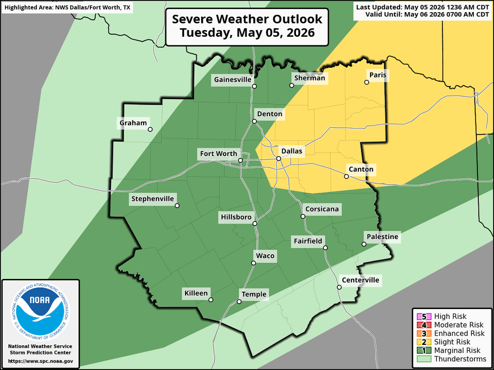
There is a conditional risk of severe storms between 5:00 p.m. and 11:00 p.m. this evening. Large hail and damaging winds will be the primary threats. Any storms that develop will be slow-moving and capable of producing heavy rainfall as they gradually track east-southeast through the evening. At this time, storm coverage is expected to remain limited, with about a 30 percent chance of severe weather.
I’ll continue to monitor the situation closely and provide updates every 10 minutes if necessary. Keep in mind this is a conditional forecast, and there is still uncertainty regarding storm development and intensity.
By tomorrow morning, the cold front should be south of the area, setting up a sharp temperature contrast across North Texas. Morning lows will range from the 50s north of the front to around 70 degrees south of the front. Highs tomorrow will likely stay in the 60s north of the front, while areas south of the boundary could reach the 80s.
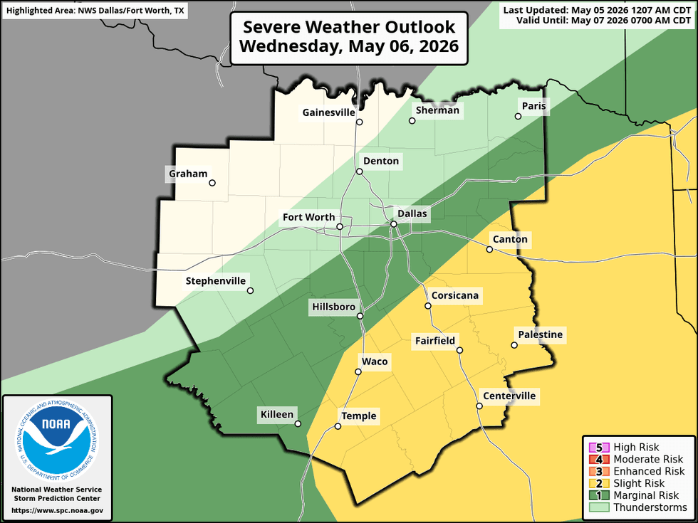
There will also be a chance for scattered severe storms tomorrow afternoon and evening, mainly south and east of the Dallas-Fort Worth area. Large hail and damaging winds will again be the primary threats.
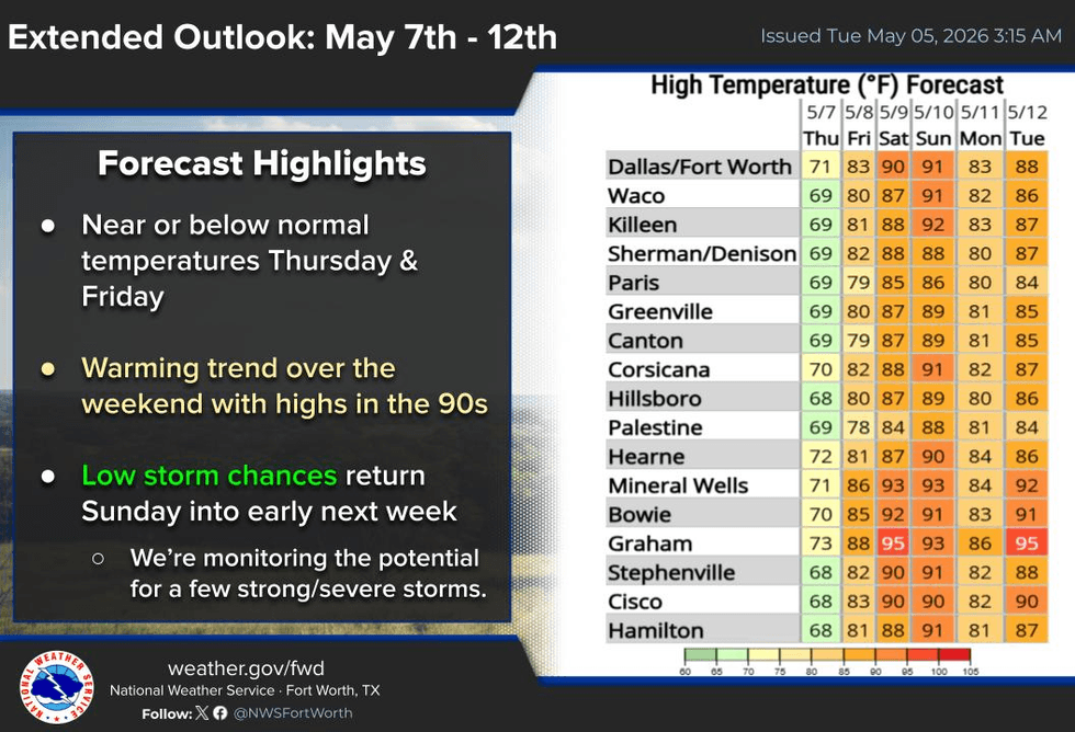
Clouds will be slow to clear on Thursday, and highs may remain in the mid to upper 60s. A quick warm-up arrives Friday, with afternoon temperatures climbing into the low 80s as south winds return and Gulf moisture increases.
Another cold front will approach the Red River early Saturday morning, bringing another chance of storms to northern North Texas. Afternoon highs on Saturday could approach 90 degrees, depending on how much sunshine we see.
Most of Sunday looks dry, with highs again nearing 90 degrees. Another front will move in Sunday evening, bringing showers and thunderstorms. Some of those storms could become severe, but the timing, track, and strength of that system remain uncertain.
Monday looks dry behind the front, with sunny skies and highs in the mid to upper 70s.
I’ll continue to monitor the storm threat this evening and will have another update later this afternoon. Have a great day, and enjoy the weather when you can, it's the only weather you've got!
7-Day Headlines: * DFW Airport reached 82 yesterday.
* Conditional risk for storms today (6pm-11pm)
* Evening cold front. Cooler weather in the way.
* Monitoring for severe storms south and east on Wednesday.
* Below average temperatures Wednesday – Friday.
* Scattered storms this weekend, some severe. Warmer.
*Yest Rain: 0.00”; Yest High: 82; Low: 62*
Today’s Averages: High: 81; Low: 61
*Record high: 96 (2023); Record low 44 (1917, 1935)
*May rain: 0.01”; Deficit: <0.58”>
*2026 Rain: 10.23”; Snow: 2.4” Deficit: <2.17”>
*Sunrise: 6:36am; Sunset: 8:14pm
Tuesday: Morning clouds, some afternoon sun. Warm and windy. Conditional risk for severe storms after 6pm to 11pm (East of a Dallas to McKinney line) Threats: Large hail, damaging wind. High: Low 90s. Wind: SW 15-25, G30 mph.
Tuesday night: Slight early evening storm chance. Stalling cold front. Low: 50-70. Wind: NNE 10-20 mph.
Wednesday: Mostly cloudy and cooler. Scattered late afternoon and evening severe storms (south and east of DFW).Threats: Large hail, damaging wind. Wind: North 10-15 mph. High: 65-80.
Thursday: Partly cloudy and perfect. High: Low 70s.
Friday: Mostly sunny and warmer. High: Low 80s.
Saturday: Isolated morning storms, becoming partly cloudy and warm. High: Near 90.
Sunday: Morning clouds, afternoon sun. Evening cold front brings the threat for strong storms. High: Near 90.
Monday: Mostly sunny, breezy and cooler. High: Upper 70s.


