Near-average temperatures, a few late-day showers and thunderstorms, and a pretty nice Fourth of July weekend are shaping up for North Texas. Good morning, everyone! Hope you're having a great start to your day.
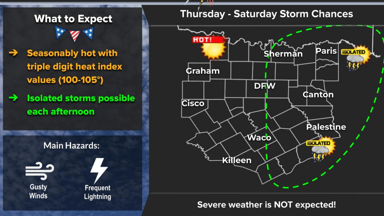
We'll have a slight chance of showers and thunderstorms today and tomorrow, with about 20 to 30 percent coverage. The best chances will be along and east of a line from Sherman to McKinney to Dallas and Waxahachie. Any storms that develop will form during the heat of the afternoon, then gradually fade after sunset. They'll be slow movers, capable of producing locally heavy rainfall before new storms develop along their outflow boundaries.
High temperatures today will reach the mid to upper 90s, with heat index values close to 100 degrees. Friday will be very similar, although storm coverage should be a little more isolated.
The Fourth of July and much of Saturday look rain-free with afternoon highs in the upper 90s—great news if you have outdoor plans. By Sunday and Monday, scattered showers and thunderstorms return, with the best chances along and west of a line from Gainesville to Denton to Fort Worth and Cleburne. The main threats will be frequent lightning, brief heavy downpours, and gusty winds.
If you're spending time on one of the area lakes this holiday weekend and you hear thunder, get off the water immediately. Remember, if you can hear thunder, you're close enough to be struck by lightning.
Looking ahead to next week, high pressure builds back over Texas, bringing sinking air and another warming trend. Highs will climb back into the upper 90s, and we could see our first 100-degree day of the year by the middle to end of next week.
Have a great day, enjoy the holiday weekend, and enjoy the weather when you can... it's the only weather you've got!
7-Day Headlines:
- DFW Airport hit 96 degrees on Thursday
- Scattered showers and storms today - early next week
- Best chance Dallas -> east today and Friday
- Isolated on The 4th of July
- Scattered Sunday - Tuesday (West of the Mid Cities)
- Seasonable temperatures (Mid to upper 90s)
- Mosquitoes for all to enjoy. DEET for 600 Alex
- Download our AUDACY app. Listen to KRLD at home or at work
Almanac:
- Yest Rain: 0.00”; Yest High: 96; Low: 79
- Today’s Averages: High: 94; Low: 75
- Record high: 110 (1980); Record low 65 (1924, 1943)
- July rain: 0.00”; Deficit: <0.11”>
- 2026 Rain: 21.25”; Snow: 2.4”; Surplus: 0.85”
- Sunrise: 6:24am; Sunset: 8:40pm
Forecast:
Thursday: Partly cloudy and hot. Isolated late day showers and storms, especially along and EAST of DFW. High: Mid to upper 90s. Heat index: Near 100 degrees. Wind: SE 10-15 mph.
Thursday night: Partly cloudy, mild and muggy. Low: Upper 70s. Wind: South 5-10 mph.
Friday: Partly cloudy and hot. 30% chance of late day showers and storms. High: Mid to upper 90s. Heat index: Near 102 degrees.Wind: South 5-10 mph.
Independence Day: Partly cloudy and hot. 20% chance of afternoon and early evening showers and storms. High: Upper 90s.
Sunday: Partly cloudy and hot. 30% chance of afternoon and early evening showers and storms. High: Mid to upper 90s.
Monday and Tuesday: Partly cloudy and hot. 30% chance of afternoon and early evening showers and storms. High: Mid to upper 90s.
Wednesday: Mostly sunny and hot. High: Upper 90s.
LISTEN on the Audacy App
Tell your Smart Speaker to "PLAY 1080 KRLD"
Sign Up to receive our KRLD Insider Newsletter for more news
Follow us on Facebook | Twitter | Instagram | YouTube