Some areas along Interstate 35 saw up to 2 inches of rain Tuesday evening, and as of 7:15 p.m., all warnings expired across North Texas.
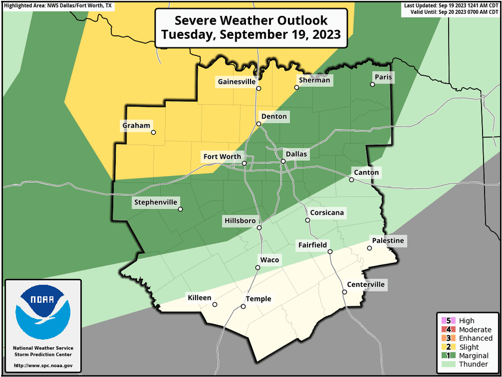
Another cluster of severe storms broke out a couple hundred miles to the northwest of Dallas-Fort Worth, where a Severe Thunderstorm Watch was in effect until 11 p.m. If the storms hold together, they will impact areas along and north of Interstate 20 towards 12 a.m. Isolated severe storms are possible.
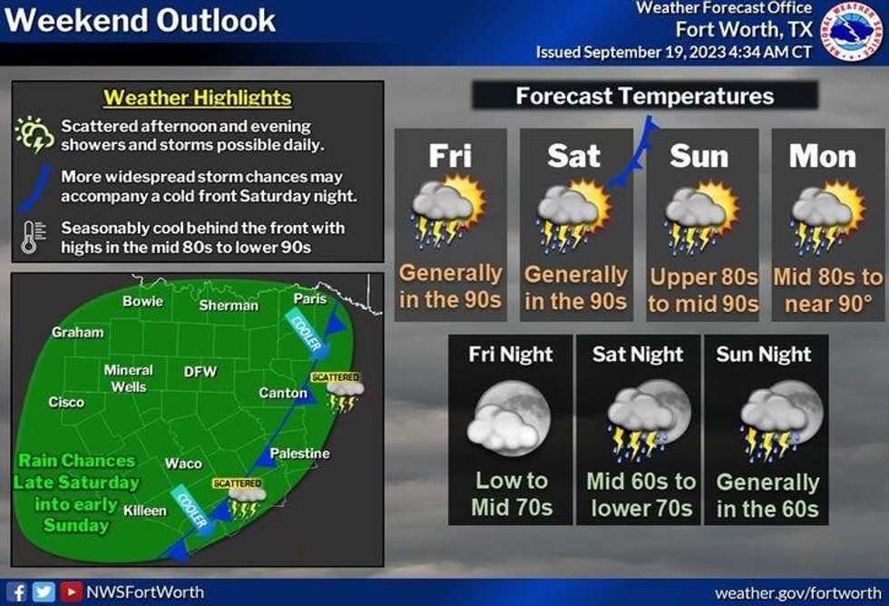
Looking at temperatures through Saturday -- afternoon highs will be in the low to mid 90s with increasing humidity. The heat index will be in the upper 90s.
When it comes to the storm threats, an upper-level ridge of high pressure is parked across much of Texas. In North Texas, we're on the northeastern quadrant of this upper high. Upper-level disturbances will travel from northwest to southeast later today through the end of the week. This coupled with the dry line surging out of West Texas and an increase in surface moisture will create thunderstorm chances almost every evening through Friday.
 National Weather Service - Fort Worth
The highest coverage of storms will be Tuesday night and then again Thursday night into Friday, but I can't rule out storms late tomorrow evening, especially towards the Red River Valley.
 National Weather Service - Fort Worth
Our next possible weather change arrives late Saturday into Sunday as a weak cold front parks itself close to the area. It's still way too early to tell how wide the coverage will be, but at least we have rain in the forecast towards the end of the seven day.
Right now, I'm going to keep Monday dry with slightly cooler temperatures. Afternoon highs will be in the mid 80s.
*Yest Rain: 0.00"; Yest High: 94; Low: 66
*Today's Averages: High: 88; Low: 67
*Record high: 102 (1956): Record low: 45 (1981)
*September Rain: 0.31"; Deficit: 1.44
*2023 Rain: 15.14"; Deficit: 11.16
*Sunrise: 7:14am; Sunset: 7:29pm
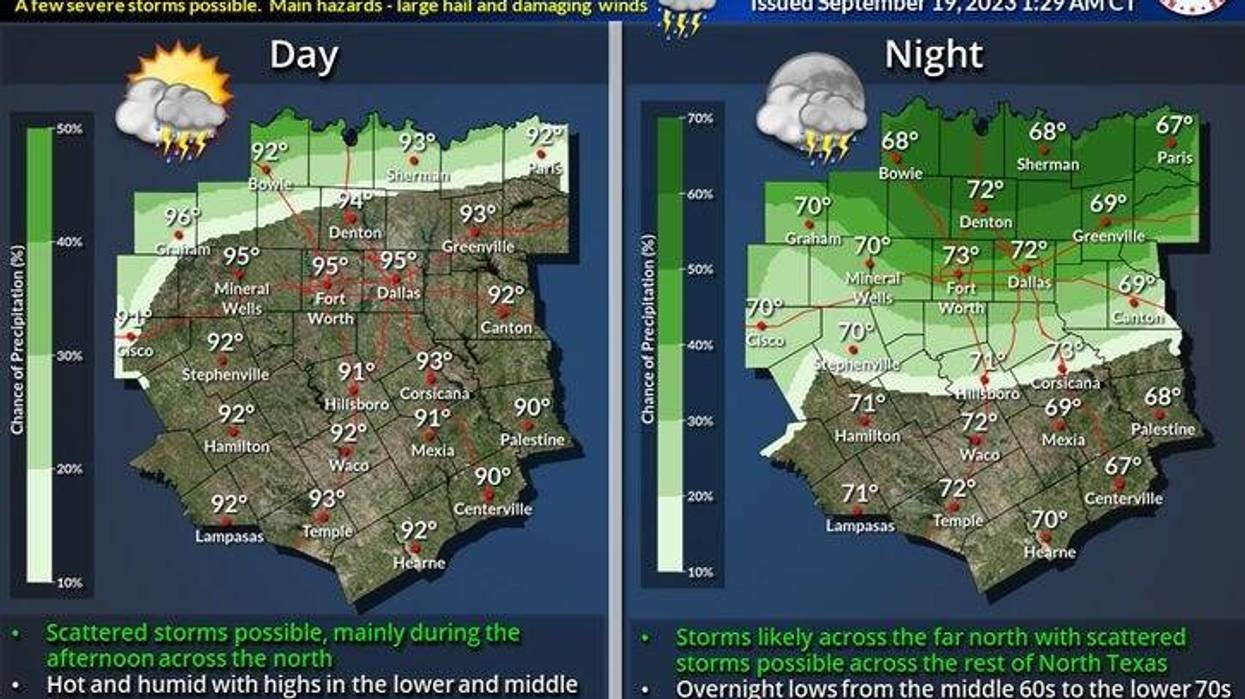
Today: Mostly sunny and warm. High: Low to mid 90s. Wind: South 10-20, G25 mph.
Tonight: Cloudy and mild. Scattered strong and severe thunderstorms (6pm-6am). Threats: Quarter hail and damaging wind. Low: 68-73. Wind: South 15-25 mph.
Wednesday: Scattered morning showers and strong storms, then Partly cloudy, breezy and warm. Scattered late evening storms. Isolated severe by late evening (north of I-20). Threats: Hail and damaging wind. High: Low 90s. Wind: South 15-25 mph.
Thursday and Friday: Partly cloudy, windy and warm. Slight chance of late day showers and storms. High: Low to mid 90s.
Saturday: *First day of Fall (1:50am)* Partly cloudy, windy and warm. Scattered late days showers and storms. High: Low to mid 90s.
Sunday: Partly cloudy and warm. Scattered late day showers and storms. High: Upper 80s.
Monday: Partly cloudy and a bit cooler. High: Mid 80s.
LISTEN on the Audacy App
Tell your Smart Speaker to "PLAY 1080 KRLD"
Sign Up to receive our KRLD Insider Newsletter for more news
Follow us on Facebook | Twitter | Instagram | YouTube