


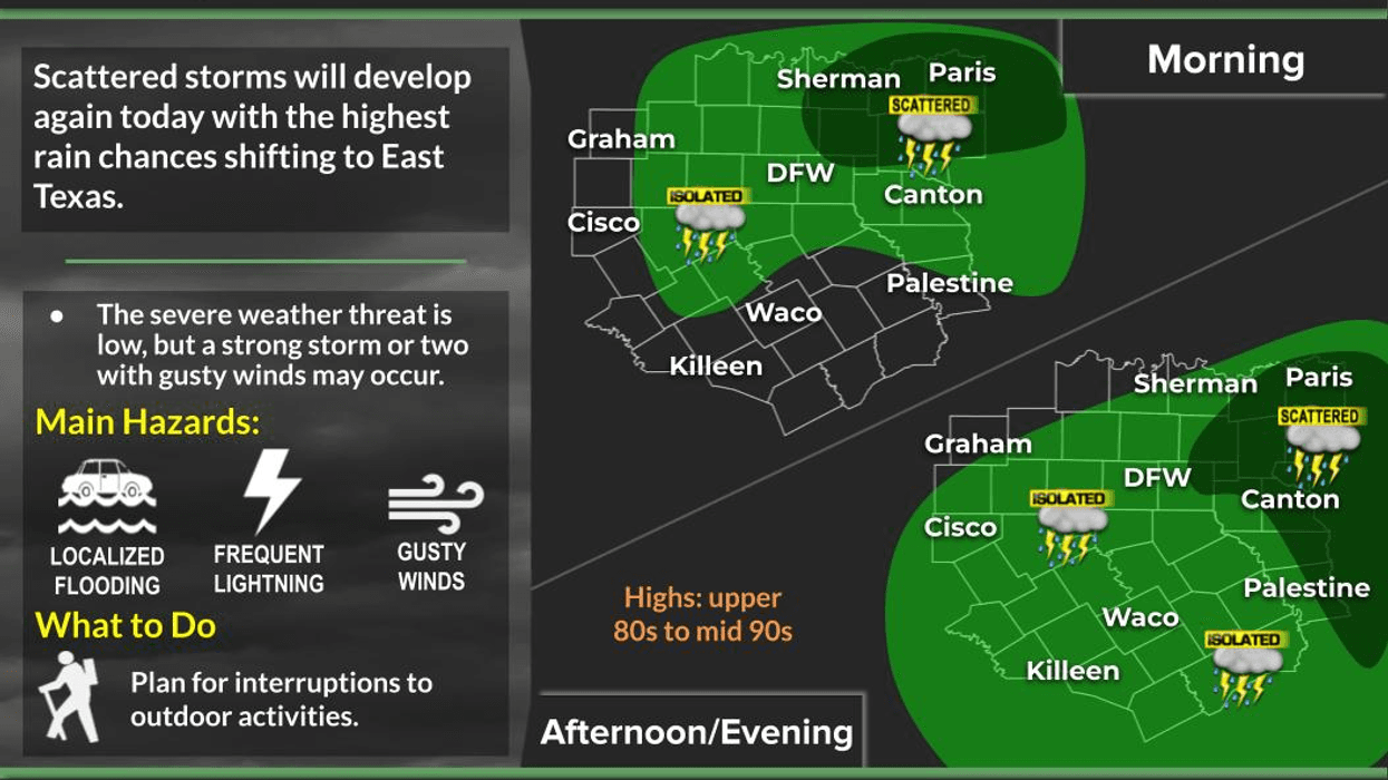
A diminished threat of widespread heavy rain is expected across the state, although some areas in North Texas may experience showers or storms today and tomorrow.
Following four consecutive days of rain in North Texas, an additional couple of days of precipitation are anticipated through tomorrow. An area of low pressure remains stagnant over central Texas, albeit weaker than in previous days. Despite its weakened state, the combination of ample moisture and daytime heating necessitates the inclusion of scattered showers and isolated storms in the forecast for today and tomorrow. Furthermore, there is a possibility of storms migrating from Oklahoma tomorrow morning and again on Thursday morning, although short-range model data is inconsistent in its predictions.
A temporary reprieve from precipitation is expected for most of Thursday and Friday, with afternoon and evening showers and storms potentially returning over the weekend, albeit with most areas remaining dry.
Temperatures over the next seven days are anticipated to be near average for this time of year, with average highs reaching 95 degrees. While highs will be in the low 90s today, they will approach the mid-90s tomorrow and throughout the weekend. Factoring in humidity, temperatures are expected to feel close to 100 degrees. It is essential to stay cool and hydrated.
In the Hill Country, scattered showers and storms are forecasted for today, with a gradual drying trend expected towards the end of the week and weekend. Similarly, Central Texas can anticipate a decrease in precipitation. All flood watches have been canceled or allowed to expire. This situation is expected to persist indefinitely...great news!
Have a great day and enjoy the weather when you can, it's the only weather you've got!
7-Day Headlines:
DFW hit 91 degrees on Tuesday. 0.10" of rain at DFW.
Scattered showers and isolated storms today – Thursday.
Heavy rain makers, weakening by sunset.
Most will stay dry.
Below average temperatures for a bit longer.
Drying out later this week.
No triples digits yet!!!
*Yest Rain: 0.10"; Yest High: 91 Low: 74
*Today's Averages: High: 95; Low: 75
*Record high: 107 (1956); Record low: 62 (1952)
*July Rain: 0.19"; Deficit:
*2025 Rain: 20.83"; Deficit:
*Sunrise: 6:27am; Sunset: 8:39pm
Tuesday: Partly cloudy, warm and humid. Scattered afternoon showers and isolated storms, dissipating by sunset. High: Low 90s. Wind: South 5-10 mph.
Tuesday night: Mostly clear and humid. Low: Mid to upper 70s.
Wednesday: Partly cloudy, warm and humid. Isolated showers and storms. High: Low to mid 90s.
Thursday and Friday: Partly cloudy, warm and humid. High: Mid 90s.
Weekend: Mostly sunny, hot and humid. Isolated showers and storms. Highs: Mid 90s.
Monday: Mostly sunny, hot and humid. High: Mid 90s.
LISTEN on the Audacy App
Tell your Smart Speaker to "PLAY 1080 KRLD"
Sign Up to receive our KRLD Insider Newsletter for more news
Follow us on Facebook | Twitter | Instagram | YouTube


