
Good morning, everyone! I hope you all had a wonderful Fourth of July weekend!
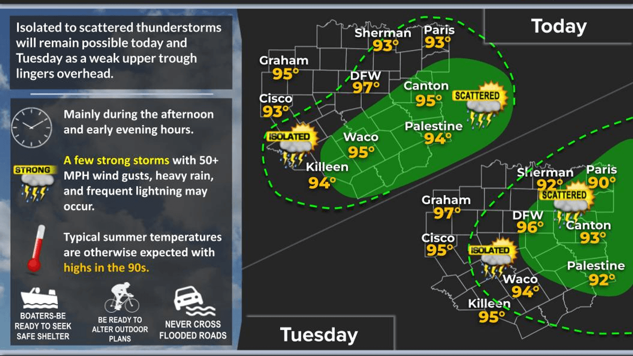
Unfortunately, many of us missed out on the rain yesterday across North Texas, but a lucky few picked up some much-needed showers in their neighborhoods. We still have another chance for a few late afternoon and early evening showers and thunderstorms today and again tomorrow as a weak disturbance moves through the ArkLaTex region.
With a little more cloud cover around, afternoon highs should generally stay in the mid-90s, although a few spots west of Fort Worth could still reach the upper 90s.
Then, the heat begins to build. From Wednesday through Friday, high pressure will gradually strengthen over North Texas. If everything comes together, we could see our first 100° temperatures of the year on Thursday or Friday.
But wait... there's more!
Forecast models suggest the ridge of high pressure may weaken and split apart heading into next weekend. That could allow Gulf moisture to work back into the region, bringing at least a chance for scattered afternoon and evening showers and thunderstorms. Keep in mind this is still a Day 6 and Day 7 forecast, so there will likely be changes over the next several days.
If those rain chances materialize, temperatures would settle back into the mid to upper 90s, which is right around average for this time of year.
Have a great Monday, everyone. Back to work we go... yippee!
— Meteorologist Dan Brounoff, in the KRLD Weather Center
7-Day Headlines:
- DFW Airport hit 97 degrees on Sunday
- Isolated late-day showers and storms today and Tuesday
- Best chance Dallas -> east
- Heating up Wednesday - Friday. 100 degrees for some
- Wind returns after Wednesday
- Storm chances may increase this weekend
- Download our AUDACY app. Listen to KRLD at home or at work
Almanac:
- Yest Rain: 0.00”; Yest High: 97; Low: 75
- Today’s Averages: High: 94; Low: 75
- Record high: 105 (1980, 1996); Record low 59 (1972)
- July rain: 0.00”; Deficit: <0.51”>
- 2026 Rain: 21.25”; Snow: 2.4”; Surplus: 0.45”
- Sunrise: 6:26am; Sunset: 8:40pm
Forecast:
Monday: Partly cloudy and hot. Isolated late day showers and storms, especially and southeast of DFW. High: Mid to upper 90s. Heat index: Near 100 degrees. Wind: Variable 5 mph.
Monday night: Partly cloudy, mild and muggy. Low: mid to upper 70s. Wind: South 5 mph.
Tuesday: Partly cloudy and hot. Isolated late day showers and storms.Highest coverage east and southeast of DFW. High: Upper 90s. Heat index: Near 102. Wind: South 5 mph.
Wednesday: Mostly sunny and hot. High: Upper 90s. Heat index near 103.
Thursday and Friday: Sunny, breezy, and hot: High: Near 100. Heat index near 105.
Weekend. Partly cloudy, breezy and hot. Scattered late day showers and storms. Highs: Mid to upper 90s.
LISTEN on the Audacy App
Tell your Smart Speaker to "PLAY 1080 KRLD"
Sign Up to receive our KRLD Insider Newsletter for more news
Follow us on Facebook | Twitter | Instagram | YouTube