High pressure remains in control across North Texas for the next few days. We're on the western side of that ridge, which gives us a southeasterly flow in the upper levels of the atmosphere. That will allow a few weak disturbances to move into East Texas beginning tomorrow, with better chances Thursday and Friday.
As we head into the holiday weekend, another upper-level low looks like it will become trapped over the western half of Texas. I mentioned this possibility late last week, and it's still looking like we could see scattered afternoon and evening showers and thunderstorms Saturday, the Fourth of July, and again Sunday. I hope I'm wrong because of all the outdoor plans, but we certainly need the rain.
Any storms that develop should be hit-or-miss, mainly during the afternoon, ending shortly after sunset. I'll be watching them closely throughout the week and will keep you updated on the timing and location, especially with all the fireworks displays planned across North Texas.
Temperatures will remain in the upper 90s through the end of the week and into the holiday weekend. Heat index values will climb to around 102 to 103 degrees, although afternoon humidity will gradually ease as the soil dries out.
Saharan dust will remain in the atmosphere today and tomorrow before moving out by Thursday. Winds will also begin to relax later this week, which is good news for boaters on the lakes and golfers. If you're planning to play golf, an early tee time around 6:30 or 7:00 a.m. is your best bet before the heat really sets in.
By late in the weekend, temperatures may come down a couple of degrees thanks to increased cloud cover and any scattered storms that develop. A few of those storms could produce gusty winds, frequent lightning, and small hail.
I'll continue tracking that upper-level low and keep you updated throughout the week. Until then, have a great day, stay cool, stay hydrated, and enjoy the weather whenever you can—it's the only weather you've got!
7-Day Headlines:
- DFW Airport hit 98 degrees on Wednesday
- Saharan dust through Wednesday
- Upper 90s through the holiday weekend
- Wind relaxes Thursday
- Scattered afternoon and evening showers and storms this weekend
- Mosquitoes for all to enjoy
- Download our AUDACY app. Listen to KRLD at home or at work
Almanac:
- Yest Rain: 0.00”; Yest High: 98; Low: 81R
- Today’s Averages: High: 94; Low: 74
- Record high: 107 (1980); Record low 64 (1899)
- June rain: 8.07”; Surplus: 4.48”
- 2026 Rain: 21.25”; Snow: 2.4”; Surplus: 1.07”
- Sunrise: 6:24am; Sunset: 8:40pm
Forecast:
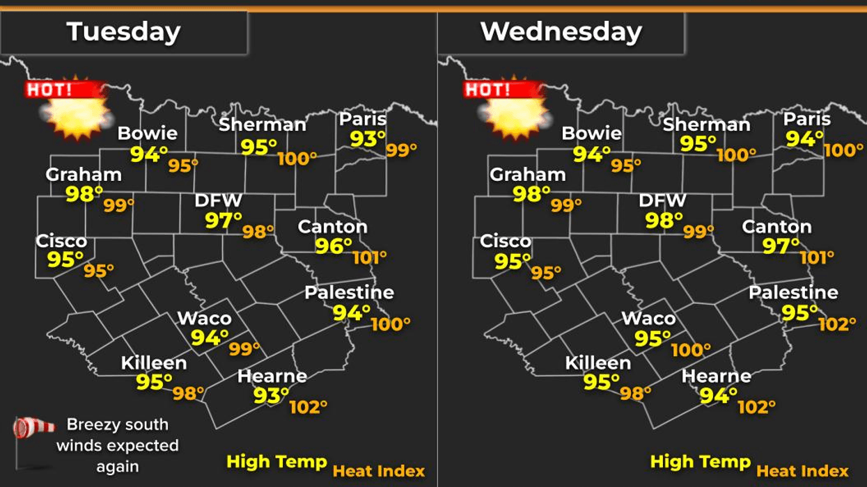
Tuesday: Mostly sunny, hot and breezy. High: Upper 90s. Heat index: Near 102 degrees. Wind: SE 15-25 mph.
Tuesday night: Clear, breezy and warm. Low: Upper 70s. Wind: South 15-25 mph.
Wednesday: Mostly sunny, hot, and breezy. High: Upper 90s. Heat index: Near 102 degrees.
Thursday and Friday: Partly cloudy, less wind and hot. Highs: Upper 90s. Heat index: Near 103.
Independence Day: Partly cloudy and hot. 30% chance of afternoon and early evening showers and storms. High: Upper 90s.
Sunday: Partly cloudy and hot. 30% chance of afternoon and early evening showers and storms. High: Upper 90s.
Monday: Partly cloudy and hot. 30% chance of afternoon and early evening showers and storms. High: Upper 90s.
LISTEN on the Audacy App
Tell your Smart Speaker to "PLAY 1080 KRLD"
Sign Up to receive our KRLD Insider Newsletter for more news
Follow us on Facebook | Twitter | Instagram | YouTube