For all of you Summer Lovers, you'll enjoy the weather this weekend. For those of you who want some rain, which I think we all do, you'll love next week's forecast. For those of you who like fall temperatures, you'll like late next weekend's forecast.
We're starting Friday with temperatures mainly in the 50s under a clear sky. Any jacket you may have on this morning will be either left on the bus later today, wrapped around your waist, or left in your backseat this afternoon. Temperatures will jump up into the low 90s!
Low 90s will be the rule again tomorrow, mid to upper 80s on Sunday, with considerable high cloudiness through the weekend.
 National Weather Service - Fort Worth
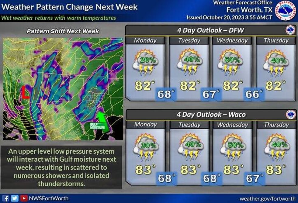
Now let's discuss next week's weather change. The remnants of what is now Hurricane Nora south of Baja California will cruise across Mexico late this weekend and move into parts of Texas Monday and Tuesday. Right now, I think the best chance of rain will be along and west of I-35E. I'll have a better idea once I see radar trends. Either way, at least we have rain back in the forecast. The clouds will also keep the temperatures from warming above 80°, on both days.
Most of Wednesday is dry until late evening. A strong upper-level disturbance will spawn widespread shower and thunderstorm activity across the Panhandle and South Plains on Wednesday afternoon. This cluster of storms will form into a line of storms and race east late Wednesday through mid-morning Thursday. It's still too early to tell where the heaviest rain will fall and how severe these storms will be. Usually, squall lines (a line of storms) that move through in the middle of the night contain damaging wind, that's it. It's also too early to tell how much rain we'll see next week, but most of you will get some welcome rain.
 NOAA
NOAA
Afternoon highs on Wednesday will reach the low 80s, and mid-80s on Thursday and then it's a coin flip after that, when the strong cold front comes through the area. Is it Friday, Saturday, or Sunday? If it waits until Sunday, we'll have more waves of rain through the weekend.
*Yest Rain: 0.00"; Yest High: 87; Low: 56
*Today's Averages: High: 77; Low: 56
*Record high: 95 (1934): Record low: 33 (1989)
*October Rain: 1.04"; Deficit: 1.45
*2023 Rain: 16.70"; Deficit: 13.06
*Sunrise: 7:36am; Sunset: 6:49pm
Today: Mostly sunny and warm. High: Low 90s. Wind: North 5-10 mph.
Tonight: Clear and mild. Low: 55-63. Wind: Lt. Var.
Saturday: Increasing high clouds and warm. High: Low 90s. Wind: South 5-10 mph.
Sunday: Mostly cloudy, continued warm. High: Mid 80s.
Monday and Tuesday: Cloudy and cooler, Scattered showers and storms. Best chance west of I-35E. Breezy and humid. High: Upper 70s.
Wednesday: Mostly to partly cloudy and windy. Storm chances increase towards midnight. Isolated severe (Threat: Damaging wind). High: Low 80s.
Thursday: Morning rain, some afternoon sun. Windy. High: Mid 80s.
LISTEN on the Audacy App
Tell your Smart Speaker to "PLAY 1080 KRLD"
Sign Up to receive our KRLD Insider Newsletter for more news
Follow us on Facebook | Twitter | Instagram | YouTube