


Above-average temperatures continue as we flirt with the 90° mark tomorrow and Saturday. There will be slightly cooler weather next week due to clouds and rain coming back into the forecast.
We've got a weak cold front moving through North Texas this morning, but unfortunately, there's no cooler air behind it or rain. It will keep the humidity levels on the low side today and tomorrow, but not cool us off.
Thursday starts off in the 50s, and 60s in town, and we will be warming into the low to mid-80s later today. A north wind will blow at 10 to 20 mph. There is a high grass fire danger west of Fort Worth.
Temperatures will cool off overnight into the low to mid-50s under a clear sky. Some high clouds will drift around the area tomorrow as temperatures warm up rapidly to near 90°, especially west of Fort Worth.
 National Weather Service - Fort Worth
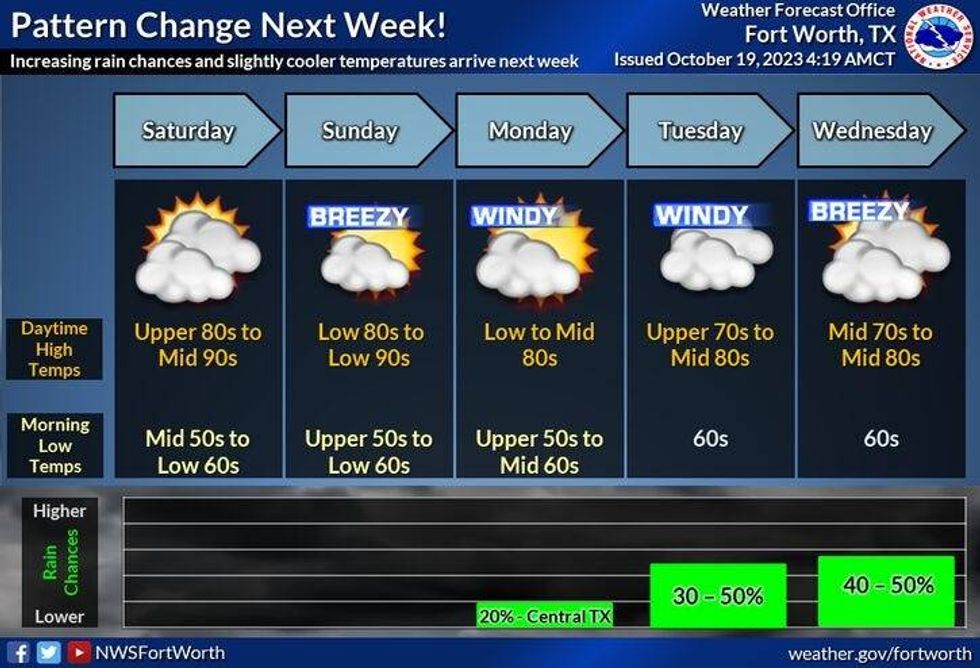
This weekend will be nice, and not nearly as cool as the past couple of weekends. High clouds will invade the area with afternoon highs and the low 90s on Saturday and mid-80s on Sunday due to more cloud cover. Get out and enjoy the last weekend of the State Fair of Texas.
Our next weather maker arrives from Mexico, as the leftover moisture from what is now Hurricane Norma in the Eastern Pacific arrives across the state. It's still too early to tell where the core of the moisture will be on Monday and Tuesday, but I am introducing showers and storms back in our forecast. Due to the clouds around next Monday and Tuesday and rain chances being back, afternoon highs will only reach the mid to upper 70s.
 NOAA
NOAA
I think we get a break in the rain on Wednesday before our next system moves In from the West late Thursday into Friday. Some severe storms are possible. After that, there are signs of a strong cold front moving through into the next weekend.
*Yest Rain: 0.00"; Yest High: 82; Low: 55
*Today's Averages: High: 77; Low: 56
*Record high: 93 (1921): Record low: 38 (1989)
*October Rain: 1.04"; Deficit: 1.28
*2023 Rain: 16.70"; Deficit: 12.89
*Sunrise: 7:35am; Sunset: 6:50pm
Today: Sunny and warm. High grass fire danger west of I-35W. High: Low to mid 80s. Wind: NNW 10-20 mph.
Tonight: Clear and cool. Low: Low to mid 50s. Wind: Lt. Var.
Friday: Sunny, breezy and warm. High: Low 90s. Wind: NW 5-10 mph.
Weekend: Increasing high clouds and warm. Highs: 90 Saturday; 85 Sunday.
Monday and Tuesday: Cloudy and cooler, Scattered showers and storms. Best chance west of I-35E. Breezy and humid. High: Mid to upper 70s.
Wednesday: Mostly to partly cloudy and windy. Isolated showers. High: Near 80
LISTEN on the Audacy App
Tell your Smart Speaker to "PLAY 1080 KRLD"
Sign Up to receive our KRLD Insider Newsletter for more news
Follow us on Facebook | Twitter | Instagram | YouTube


