


Temperatures will be chilly Tuesday and Wednesday before a rapid warm-up on Thursday and Friday. Another Arctic blast will move into North Texas early Saturday morning.
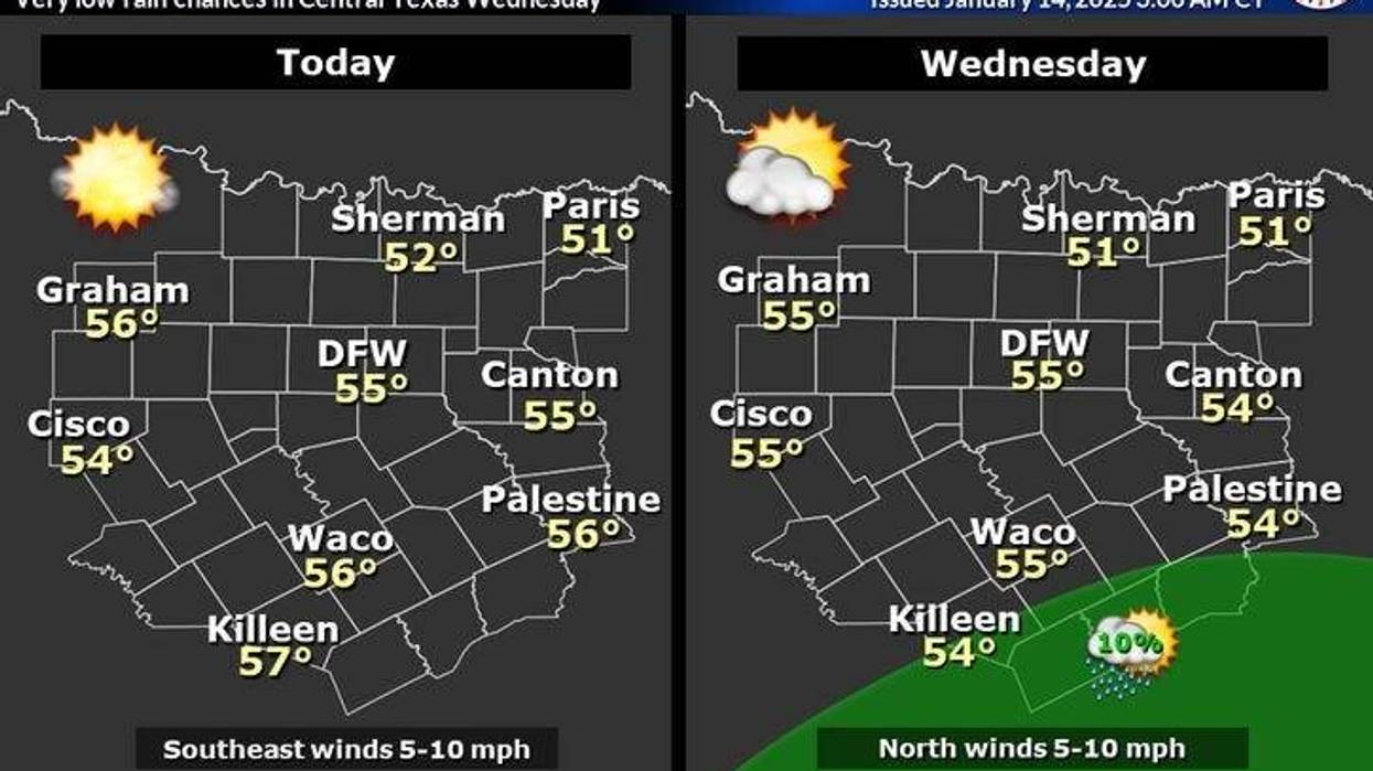
Tuesday started with temperatures in the mid-20s to low 30s, accompanied by a light wind. A beautiful day is anticipated, with ample sunshine. Afternoon highs will warm into the mid-50s with a very light south wind.
Temperatures will return to near-freezing levels away from town Wednesday morning, as temperatures rebound back into the mid-50s by afternoon. A slight increase in high cloud cover will also become apparent.
Following a light freeze early Thursday morning, south winds will resume, warming temperatures into the low 60s, accompanied by passing high clouds.
Friday will be windy, with more high cloud cover. Temperatures will warm up to the mid-to-upper 60s. A strong Arctic blast will arise before you wake up Saturday morning. It may bring a few showers to areas east of Dallas before early in the day.
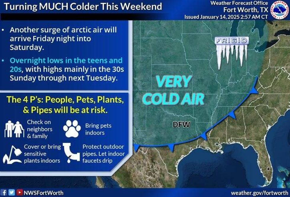
This weekend will be cold across North Texas. North winds will gust over 30 mph on Saturday, and temperatures will plummet from near 60 after midnight to near 40 by 12 p.m. Temperatures should stabilize at around 40 degrees during the day, with sunshine. Wind chills will be in the 20s throughout the day.
Clouds will increase Saturday night, and there could be a few flurries along the Red River Valley on Sunday. Temperatures will fall into the upper teens to low 20s across the area. Wind chills will be in the single digits. Sunshine will reappear by afternoon, but it will remain very cold and breezy. Afternoon highs will only reach the mid-30s.
Monday will be just as cold, with increasing clouds throughout the day. Some areas may not rise above freezing.
After next Tuesday, the forecast still has a lot of uncertainty. It is essential to monitor the track of the next upper-level disturbance and when and if a surface low forms in the northern Gulf of Mexico along the Texas coast.
 Cold front arrives in North Texas on Saturday.National Weather Service
7-Day Headlines
* DFW Airport reached 52 on Monday.
* A couple of seasonable days ahead.
* A quick warm-up on Thursday and Friday.
* Another Arctic cold front arrives early Saturday morning. Showers east of DFW.
* Windy and very cold this weekend.
* Staying cold early next week.
* Watching for wintry precipitation late Monday and Tuesday.
_____________________________________________________
*Monday Rain: 0.00"; Monday High: 52; Low: 27
*Tuesday's Averages: High: 56; Low: 36
*Record high: 79 (1928, 2022); Record low: 4 (1964)
________________________________________________________
*January Rain: 1.56"; Surplus: 0.45"
*2025 Rain: 1.56; Snow: 2.30"; Surplus: 0.45"
*Sunrise: 7:31am; Sunset: 5:44pm
________________________________________________________
Tuesday: Patchy morning ice north of DFW, then sunny and cool. High: Mid-50s. South 5 mph.
Tuesday night: Clear and cold. Low: 30-35. Wind: Calm.
Wednesday: Partly cloudy and cool. High: Mid-50s. Wind: NE 5 mph.
Thursday: Light morning freeze, then partly cloudy and warmer. High: Low 60s.
Friday: High clouds, windy, and mild. A slight chance of rain late. High Mid to upper 60s.
Saturday: Early morning showers, Dallas - > east, then turning windy and MUCH colder early. High: Low 60s early, falling temperatures through the 40s in the morning, 30s by evening.
Sunday: Morning clouds (flurries?), afternoon sun, Windy and cold. High: Mid 30s.
Monday: Increasing clouds, windy and cold. Watching for wintry precip late. High: Mid-30s.
LISTEN on the Audacy App
Tell your Smart Speaker to "PLAY 1080 KRLD"
Sign Up to receive our KRLD Insider Newsletter for more news
Follow us on Facebook | Twitter | Instagram | YouTube


