Our quiet weather pattern continues through the weekend, with no measurable rain in the forecast. Cool mornings and mild to pleasant afternoons will continue. Next week, a different story. A significant pattern change will unfold, with slight rain chances and much colder temperatures to come!
A light jacket will be necessary, not just this morning, but every morning through the weekend. No jackets necessary during the afternoon as the storm track and cooler temperatures continue to reside well to the north of the Lone Star State.
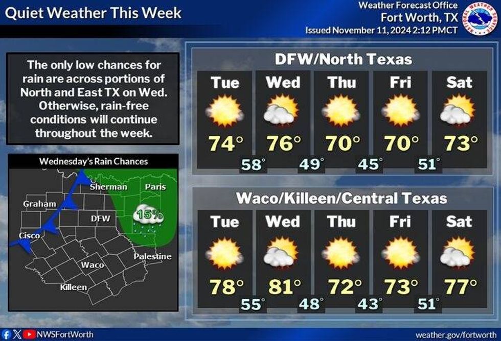
Passing high clouds today and tomorrow with highs in the mid 70s today, upper 70s tomorrow. By tomorrow evening, a weak cold front will move through the area shifting our winds to the north and dropping temperatures to near 70° for highs on Thursday and Friday. Morning lows will range from the mid 40s to low 50s.
 NWS
NWS
A south wind returns this weekend warming us into the mid 70s on Saturday, upper 70s on Sunday. By Monday evening our next cold front arrives. There is a slight chance of showers and storms along the front, however as of now, it looks like the greatest energy will shoot well to the north of the Dallas-Fort Worth area. A severe weather outbreak may break out from Oklahoma into the plains states and midwest.
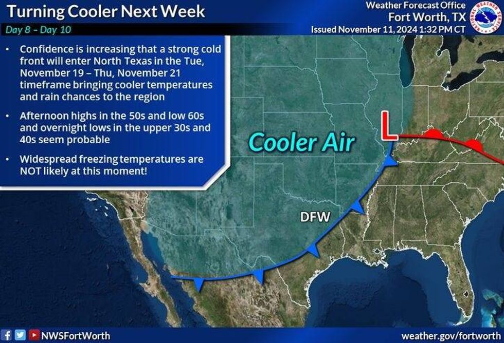
A second front will plow through here sometime during the second half of Tuesday of next week. This will drop temperature significantly through the rest of the week. Will we see our first freeze before the following weekend? Stay tuned! By the way, our average first freeze is November 22nd, that's a week from Friday.
 NWS
NWS
7-Day Headlines:
* DFW Airport reached 81 yesterday.
* A cool start, a beautiful end to today.
* A brief warmup tomorrow.
* Late Wednesday DRY cold front.
* Seasonable weather Thursday and Friday.
* Warm and breezy this weekend. Increasing humidity.
* Cooling off significantly by the middle of NEXT week. First freeze coming?
_____________________________________________________
*Yest Rain: 0.00"; Yest High: 78; Low: 53
*Today's Averages: High: 68; Low: 47
*Record high: 85 (1951, 1955); Record low: 21 (1911)
__________________________________________________________
*Novemeber Rain: 1.40"; Surplus: 0.29"
*2024 Rain: 35.45"; Surplus: 2.80"
*Sunrise: 6:56am; Sunset: 5:28pm
__________________________________________________________
Today: Sunny and beautiful. High: Mid 70s. Wind: SE 5-10 mph.
Tonight: Clear and cool. Low: Low to mid 50s. Wind: SE 5-10 mph.
Tomorrow: Sunny and perfect again. High: Mid to upper 70s. EVening DRY cold front. Wind: Shifting NE 10-20 mph.
Thursday and Friday: Sunny and beautiful. High: Near 70.
Weekend: Mostly sunny, breezy and warmer. Highs: Mid to upper 70s.
Monday: Increasing clouds, windy and warm. A slight chance of showers and storms late. High: Upper 70s.
LISTEN on the Audacy App
Tell your Smart Speaker to "PLAY 1080 KRLD"
Sign Up to receive our KRLD Insider Newsletter for more news
Follow us on Facebook | Twitter | Instagram | YouTube