


A bunch of drizzle, cooler-drier air, a perfect weekend, and a very warm Christmas week - sounds like the weather is trying to make up for your in-laws coming over. Those are your weather stories over the next 7 Days across North Texas.
Good morning my friends and followers, and welcome to almost Friday, because who's counting. We're waking up to low clouds, drizzle, and some fog across North Texas, so please slow down and allow extra time getting to work in school this morning, or you know, just blame the weather for being late.
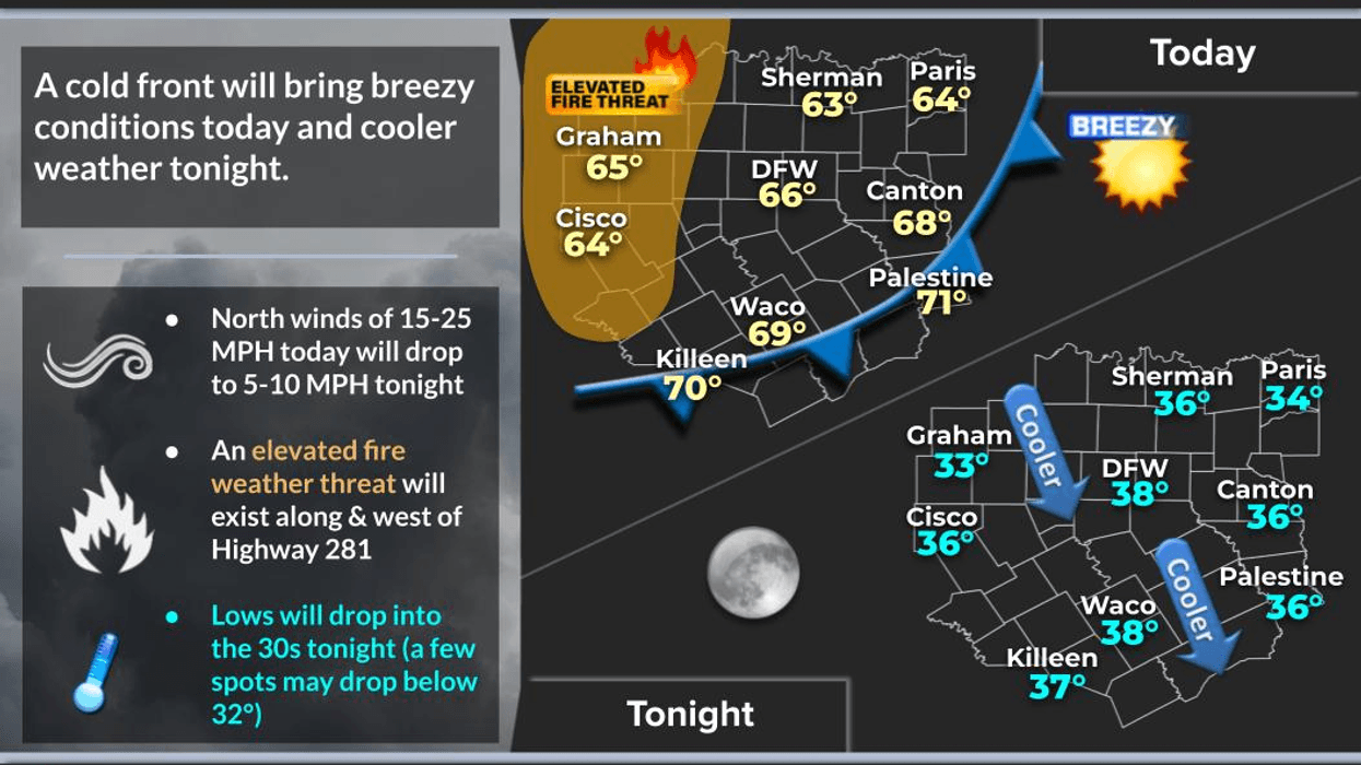
I'm tracking a cold front at this hour now edging through the northern panhandle, and by cold front, I mean a strong breeze that will make you need a heavier jacket by tomorrow morning. It's about 8 hours away, but you'll know it when it comes through, because the wind will be blowing like your aunt gossiping at Christmas dinner. Skies will rapidly clear later today, cool-dry will filter into the area at 20 to 30 mph. Please remember to dodge all the blowing leaves on the roads late this afternoon and evening, because it's like nature's confetti. Afternoon highs will level off in the mid 60s and then slowly fall through the 50s this evening.
Friday looks beautiful, because who doesn't love a day that starts with a chilly morning and ends with a sunny afternoon. We'll start the morning off chilly in the mid to upper 30s and end up in the low to mid-60s by afternoon with plenty of sunshine.
The weekend looks fantastic as well, because who doesn't love a warm-up on Saturday with highs warming into the mid-70s. It will be very windy as well. Our next subtle weather change arrives on Sunday, as another weak front slides through the area. It will knock temperatures back in the mid 60s with ample sunshine.This cold front will rapidly lift back to the north on Monday, so temperatures will rebound back into the mid-70s with more sunshine.
The rest of Christmas week will be unseasonably warm with some morning clouds and afternoon sun. Lows will only reach 60° and afternoon highs will top out in the mid to upper 70s. There will be some 80s out west of Highway 281. Records may be set as well.
A reminder, winter starts on Sunday, but it won't feel like it. There are signs in the model trends that colder air may finally move back into the area by the end of the year with some precipitation. Something I will monitor over the coming days.
That's a look at your fabulous weather discussion! Have a terrific day today, and I'm taking tomorrow off, so you won't see me. Also, please remember to enjoy the weather when you can, it's the only weather you've got!
7-Day Headlines:
* DFW Airport reached 64 yesterday.
* Drizzle and low clouds until this afternoon.
* Afternoon WINDY cold front.
* Cooler on Friday, warmer Saturday, Cooler Sunday.
* No rain for a while.
* Winter arrives on Sunday. Mid to upper 70s the Christmas week!
*Yest Rain: 0.01"; Yest High: 64; Low: 54
*Today's Averages: High: 57; Low: 38
*Record high: 81 (1977, 1980); Record low: 15 (1964)
*December Rain: 0.07"; Deficit:
*2025 Rain: 38.29"; Surplus: +2.59"
*Sunrise: 7:26am; Sunset: 5:25pm
Thursday: Morning clouds, afternoon sun. Cold front arrives. Turning windy and cooler. High: Mid 60s. Wind: South to north 15-25, G30 mph.
Thursday night: Clear, breezy and colder. Low: Mid to upper 30s. Wind: North 10-20 mph.
Friday: Clear and cool. Less wind. High: Low 60s. Wind: South 10-20 mph.
Saturday: Mostly sunny, breezy and MUCH warmer. High: Mid to upper 70s.
Sunday: *WINTER ARRIVES* Increasing clouds and a bit cooler. Noon 'WEAK' cold front. High: Near 60.
Monday: Mostly sunny and unseasonably warm. High: Low 70s.
Tuesday and Wednesday: Mostly sunny and warm. High: Mid to upper 70s.
LISTEN on the Audacy App
Tell your Smart Speaker to "PLAY 1080 KRLD"
Sign Up to receive our KRLD Insider Newsletter for more news
Follow us on Facebook | Twitter | Instagram | YouTube


