We made it to another holiday weekend! As you enjoy your time off across North Texas, please stay weather aware — especially if your plans take you into the Hill Country, the Texas Coast, or South Texas.
Flood Watches remain in effect through the entire weekend across many of these areas. If you’ll be spending time on the rivers, lakes, or beaches, make sure to check the forecast frequently, especially before heading out in the morning and again before going to bed each night. Keep a NOAA Weather Radio nearby as well.
Recreational rivers across the Hill Country — including the Guadalupe, Frio, Blanco, and Colorado Rivers — could experience significant rises and possible flooding depending on where the heaviest storms develop.
Good morning everyone! Hope you have a safe and enjoyable Memorial Day weekend ahead.
Here in North Texas, showers and thunderstorms will remain in the forecast through Memorial Day. The greatest chance for widespread rain appears to be Saturday morning, with more scattered afternoon and evening storms expected Saturday, Sunday, and Monday. The heaviest rainfall is expected to stay mainly south of North Texas, while storm chances may shift more toward East Texas by Memorial Day itself.
Temperatures this weekend will generally stay in the 80s, with some locations holding in the 70s during periods of rain.
The main storm threats this weekend will be:
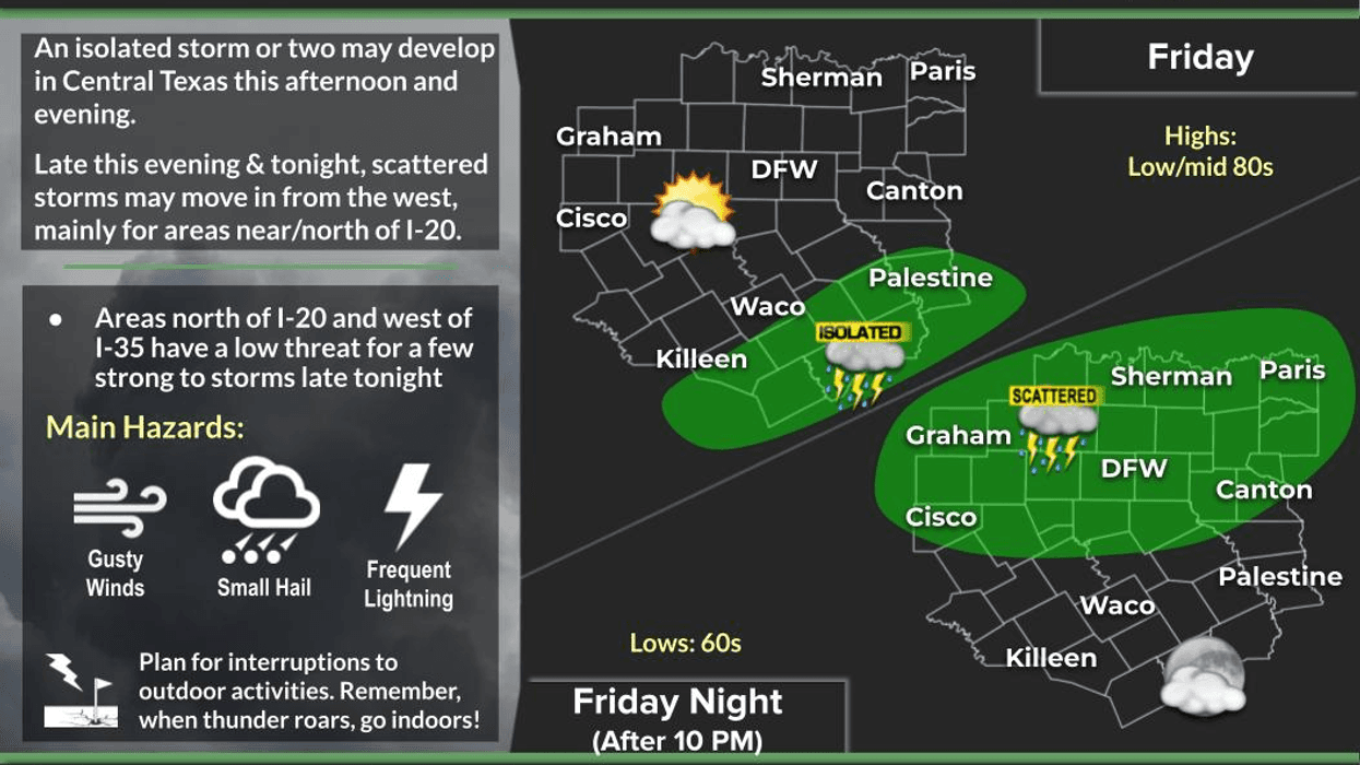
• Frequent lightning
• Heavy rainfall and localized flooding
• Ponding on roads and in low-lying areas
Some locations may not receive much rain at all, while others could see very heavy downpours in a short amount of time — especially areas that have already picked up significant rainfall over the past few days.
We may catch a brief break in the rain Tuesday before another storm system increases rain chances again by Wednesday and Thursday.
Have a great day today, enjoy the long weekend, and remember — enjoy the weather when you can… it’s the only weather you’ve got!
___________________________________________________
7-Day Headlines:
- DFW Airport hit 76 degrees on Thursday. Officially: 0.02” of rain
- A break in the rain on Friday
- Scattered non severe storms through Memorial Day
- Threats: Lightning, pockets of heavy rain, gusty wind
- Flooding potential in central and south Texas
- Don’t cancel your outdoor plans
- 70s in the rain, 80s in the sun
- Download our AUDACY app. Listen to KRLD at home
Almanac:
- Yest Rain: 0.02”; Yest High: 76; Low: 68
- Today’s Averages: High: 87; Low: 67
- Record high: 99 (2005); Record low 51 (1931)
- May rain: 1.93”; Deficit: <01.15”>
- 2026 Rain: 12.15”; Snow: 2.4” Deficit: <2.94”>
- Sunrise: 6:24am; Sunset: 8:26pm
Forecast:
Friday: Mostly to partly cloudy and a tad warmer. Isolated afternoon and evening storms. High: Mid 80s. Wind: ESE 5 mph.
Friday night: Increasing clouds. Scattered storms late. Low: Mid to upper 60s. Wind: ESE 5 mph.
Saturday and Sunday: Mostly to partly cloudy and warm. Scattered showers and storms. Highs: Low to mid 80s.
Memorial Day: Mostly to partly cloudy and warm. A few leftover storms. High: Low to mid 80s.
Tuesday: Mostly to partly cloudy and warmer. Isolated late day showers and storms. High: Mid 80s.
Wednesday: Mostly cloudy and warm. Scattered showers and storms. High: Upper 70s.
Thursday: Mostly to partly cloudy and warm. Isolated showers and storms. High: Near 80.
LISTEN on the Audacy App
Tell your Smart Speaker to "PLAY 1080 KRLD"
Sign Up to receive our KRLD Insider Newsletter for more news
Follow us on Facebook | Twitter | Instagram | YouTube