Prepare yourselves for a very wild week across North Texas!
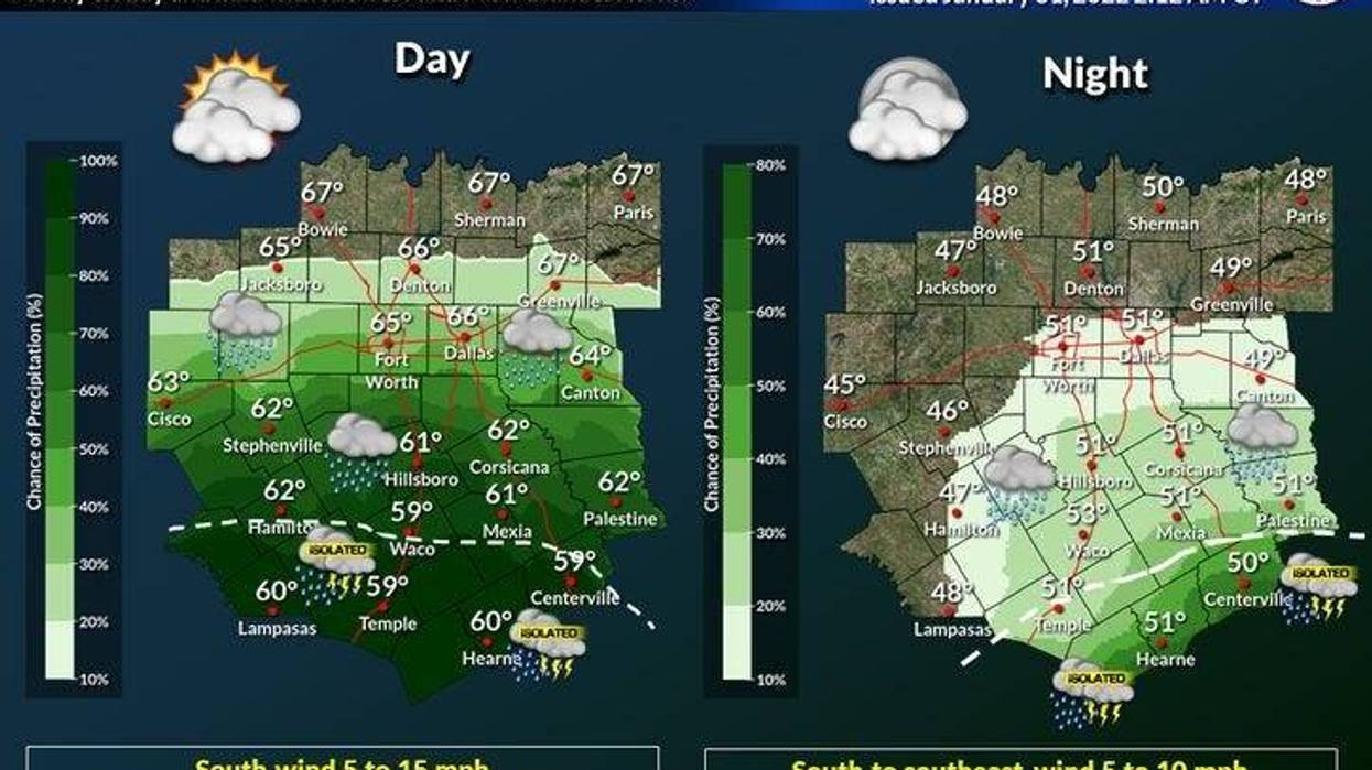
Monday and Tuesday look fine with more clouds than sun. There will be a few scattered showers around this afternoon, mainly south of I-20. The heaviest rain will fall in Central and Southeast Texas. Temperatures will go from the forties on Monday morning into the low to mid-sixties in the afternoon, mid to upper sixties on Tuesday.
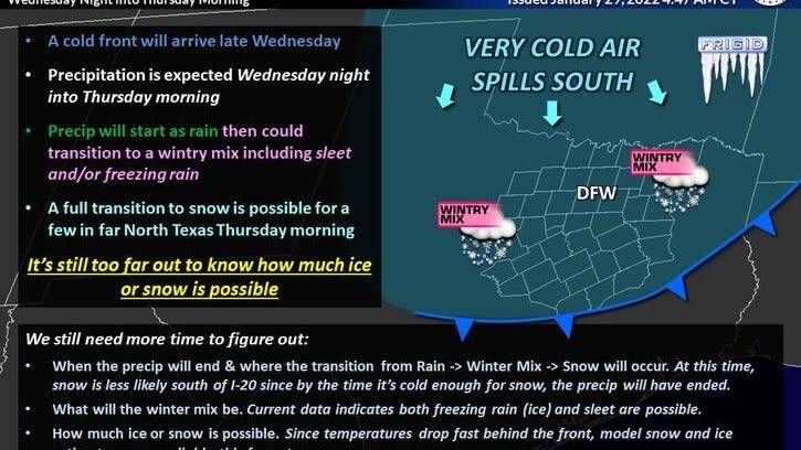
A winter storm watch is in place from 6 p.m. on Wednesday until 6 p.m. on Thursday for much of Northeastern and North Central Texas with a strong Arctic cold front slowly moving through during the late morning into the afternoon on Wednesday.
The onset of precipitation looks like it may be a little bit earlier which will be good for a quicker changeover from freezing rain to sleet with a prolonged period of heavy accumulations of sleet, ending with a bit of snow.
This will be a crippling storm!
Below are very important questions I've been asked over the last couple of days:
When will the temperatures get below freezing?
Right now, I'm thinking close to midnight into early Thursday morning in DFW... sooner north and west.
What type of precipitation will we see and when will the wintry precipitation arrive? End? How much is expected?
Rain will change over to freezing rain towards midnight night Thursday, then to sleet, then to snow Thursday morning into the afternoon. Precipitation will end from west to east during the day.
Yet to be determined, but there'll be enough to cause dangerous travel through at least Saturday afternoon. Right now, the heaviest accumulating snow will be west and north of DFW. The data right now suggests mainly freezing rain and sleet here in DFW, ending as snow late Thursday morning into the afternoon. Fact: The faster the cold air moves in the greater chances we have of seeing less freezing rain and more sleet and snow in DFW. In turn, fewer power outages. The slower the cold air moves in, the more freezing rain and sleet we will see, and less snow. In turn, more power outages. We do not want a bunch of freezing rain!
How cold will we get?
Temperatures will hover in the twenties on Thursday and Friday before we get above freezing on Saturday... For sure on Sunday. This all depends on how much snow or sleet we see. Remember that snow and sleet have a high albedo (reflects sunlight away from the Earth). So even though the sun will be out, temperatures will have a hard time warming.
Will schools be closed?
Yes, most likely Thursday and Friday.
Will this be as cold as last February?
No, but temperatures could dip into the single digits, Saturday morning... Afternoon highs will be and near 20 on Thursday, low to mid twenties Friday, and near freezing on Saturday. We should all be safely above freezing on Sunday. Please remember, anything that slightly melts during the afternoon hours will quickly refreeze after sunset. This will also occur on Sunday as well.
Will there be power outages?
Not widespread like last February, just sporadic. As stated above, this all depends on how much freezing rain we see.
Please start making your Winter preparations now. Prepare your home, prepare for power outages, and prepare your vehicles.
*Yest Rain: 0.00"; *Yest High: 71; Low: 35
*Today's Averages: High: 58; Low: 37
*Record high: 93 (1911); Record low: -2 (1949)
*January rain: 0.08"; January deficit: 2.38"
*2022 Rain: 0.08"; 2022 deficit: 2.38"
*Sunrise: 7:24am; Sunset: 6:00pm
Today: Cloudy early, partly cloudy by afternoon. Slight chance of showers, mainly south of I-20. High: Low to mid 60s. Wind: South 10-20 mph.
Tonight: Mostly cloudy and cool. Low: 48-52. Wind: SE 10 mph.
Tomorrow: Mostly cloudy and mild. High: Mid to upper 60s. Wind: SE 10-20 mph.
Wednesday: Cloudy, turning windy and colder. Good chance of a cold rain. High: Low 60s, falling into the 40s by afternoon.
Wednesday night: Cloudy, windy and very cold. Rain, changing over to a wintry mix. Accumulations possible overnight. Low: Near 20.
Thursday: Cloudy windy and cold. Sleet to snow. Accumulations possible. High: Lower 20s.
Friday: Mostly to partly cloudy, continued cold. High: Mid 20s.
Saturday: Partly cloudy and cold. High: 28-32.
Sunday: Mostly sunny, continued cold. High: Mid to upper 30s.
LISTEN on the Audacy App
Sign Up and Follow NewsRadio 1080 KRLD