


Above average temperatures, several windy days, rain chances returning, cooler temperatures, and no Arctic air anytime soon. Those are your weather stories over the next 7 days.
We're waking up to some cloud cover and very mild temperatures for this time of the year. Readings are actually above average from where they should be for afternoon highs! Go figure!
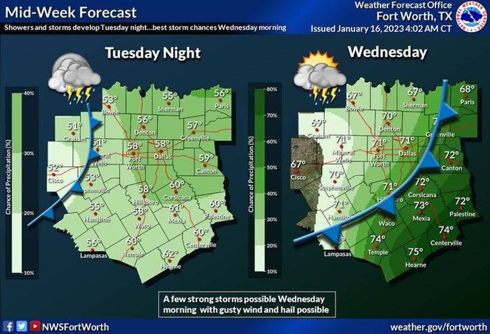
Temperatures are hovering in the low to mid 60s at this hour with cloud cover over the eastern half of north Texas. There's also a weak cold front to our west. It'll glide through the area later today, drying the air out, but temperatures will be well above average. Afternoon highs will reach the mid 70s! It will also be very windy with WSW wind gusting to 30 mph.
A few high clouds will drift overhead tonight with lows in the mid to upper 50s. We're back in the mid 70s tomorrow with increasing clouds by evening.
Scattered showers will develop before you wake up Wednesday and continue through the early afternoon. These showers will intensify in east Texas and turn into thunderstorms as this system races into east Texas by evening. As of now, I'm not concerned about severe weather for north Texas.
Clearing windy and cooler for Thursday and Friday with highs in the mid fifties Thursday, near 60 on Friday.
Our next system rapidly approaches on Saturday, bringing a chance of a chilly rain with it. High temperatures may not get above 50°, Stay tuned.
Saturday's system will be a fast mover, so we'll clear out rapidly on Sunday, with highs seasonal in the mid fifties.
I usually don't go this far out with my forecast, but the following week may trend much colder with possible precipitation.. stay tuned on that forecast. Enjoy the heck out of your day off, go Cowboys, and please enjoy the weather when you can, it's the only weather you've got.
_________________________________________________________
 NWS
NWS
7-Day Headlines:
* DFW reached 71 degrees yesterday
* Mild mornings, warm afternoons.
* Windy today, Thurs, Fri, and Sun.
* Rain chances Wednesday and Saturday.
* Cooler Thursday-Sunday.
* Trending colder next week.
________________________________________________________
*Yest Rain: 0.00"; High: 71; Low: 49
*Today's Averages: High: 56; Low: 36
*Record high: 81 (1935); Record low: 11 (1930)
_________________________________________________________
*January rain: Trace; Deficit:
*2023 rain: Trace; Deficit:
*Sunrise: 7:31am; Sunset: 5:45pm
________________________________________________________
Today: Passing high clouds, warm and windy. High: Mid 70s. Wind: WSW 15-25, G30 mph.
Tonight: High clouds, less windy, and mild. Low: 55-60. Wind: SW 5-10 mph..
Tomorrow: Increasing clouds and warm. High: Mid 70s. Wind: WSW 5-10 mph.
Wednesday: Mostly cloudy and continued mild. Scattered showers and isolated storms the first half of the day. Late evening cold front. High: Upper 60s.
Thursday: Sunny, breezy and cooler. High: Mid 50s.
Friday: Sunny, cool and calm. High: Near 60.
Saturday: Cloudy and cool. Chance of showers. High: Near 50.
Sunday: Clearing, breezy and seasonable. High: Mid 50s.
LISTEN on the Audacy App
Tell your Smart Speaker to "PLAY 1080 KRLD"
Sign Up and Follow NewsRadio 1080 KRLD


