


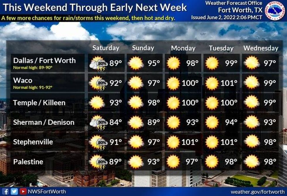
We have a chance for more scattered showers and non severe thunderstorms late this morning through the afternoon, and then again tomorrow morning.
No worries this morning though, as you head into work, as all of the rain will stay west of Interstate 35W through mid-to-late morning. An upper-level disturbance that's causing widespread heavy rain about 150 miles to our west, is forecast to weaken somewhat as it approaches north Texas by late morning into the early afternoon. This upper-level disturbance will move directly over north Texas this afternoon and may regenerate some showers and storms through the afternoon into the early evening hours. As of now, nothing severe is expected. Afternoon highs will reach the low 80s due to the clouds and rain in the area.
Another disturbance will move into west Texas late this evening producing more showers and storms. This area of rain will approach DFW by daybreak tomorrow... in a weakened state. Morning lows Saturday will be near 70, with afternoon highs in the upper 80s, sunshine returns by afternoon.
 National Weather Service - Fort Worth
One last shot of morning showers and storms on Sunday, especially in the Arklatex area. Afternoon highs will warm up, as south winds pick up and gust to 30 mph. Readings will reach the low to mid-90s. Heat index values will approach 100°.
We're back to a summer-like pattern for most of next week, as an upper level ridge of high pressure builds across the state. Afternoon highs will reach the mid-to-upper 90s Monday through Thursday. Heat index values will be slightly above 100°. Near record high temperatures are possible out to our west into the Big Country and the northwest Red River Valley. This is where temperatures will range between 103 degrees and 107 degrees. Ouch!
Some of the extended model data has another cold front sliding south of the Red River late next week. This may increase our rain chances and knock temperatures down a bit. Still days away, but something to watch.
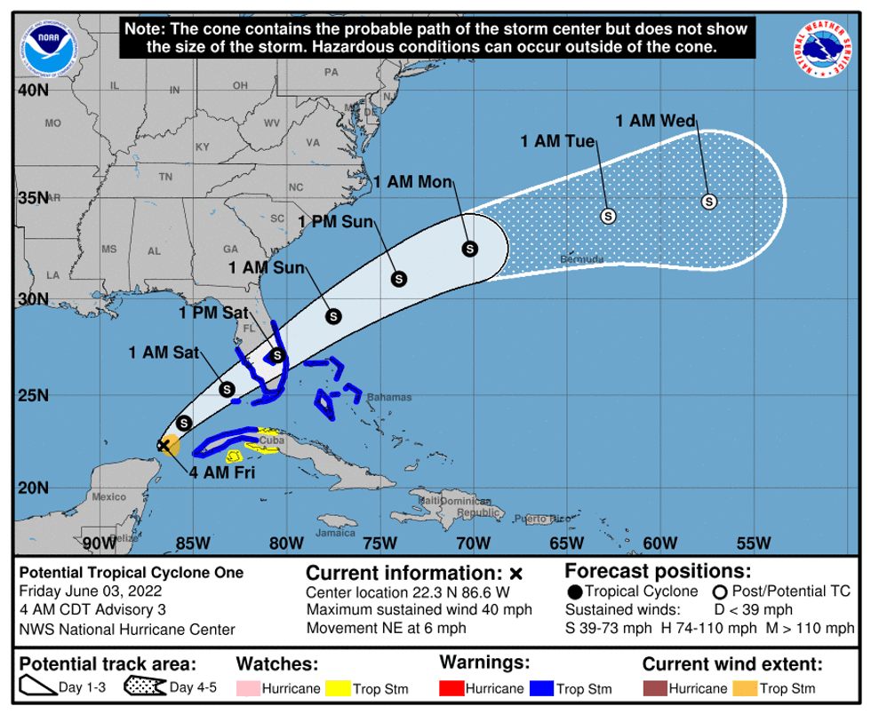
Lastly, The NHC is watching the Gulf of Mexico for possible tropical storm Alex development today. This storm will make landfall in south Florida sometime late Saturday as a weak tropical storm.
 National Weather Service
*Yest Rain: 0.38"; *Yest High: 84; Low: 65
*Today's Averages: High: 89; Low: 70
*Record high: 100 (1913); Record low: 52 (1919, 1946, 1970)
* June rain: 2.53"; June surplus: +2.26"
*2022 rain: 12.30"; 2022 deficit: 4.56"
*Sunrise: 6:20am; Sunset: 8:33pm
Today: Mostly cloudy and warm. Scattered showers and storms. Nothing severe expected. High: Low 80s. Wind: ENE 5-10 mph.
Tonight: Partly cloudy and mild. Low: 65-70. Wind: ENE 5-10 mph.
Tomorrow: Scattered morning storms, afternoon sun. Warm and humid. High: Upper 80s. Wind: SSE 10-20, G25 mph.
Sunday: Isolated morning storms, afternoon sunshine. Windy and hot. High: Mid 90s.
Monday - Thursday: Sunny, breezy, hot and humid. Highs: Mid to upper 90s; Lows: Mid 70s.

LISTEN on the Audacy App
Sign Up and Follow NewsRadio 1080 KRLD


