


A quiet weather pattern will persist throughout the week and into the weekend, except for an upper-level disturbance crossing the area today, producing extensive cloud cover and possibly scattered sprinkles.
Good morning, my friends and followers, and happy Monday! I hope you had a great weekend. It was an excellent weekend for sports, as my Aggies won, moved up in the rankings, and the Dallas Cowboys surprised me by tying the Green Bay Packers 40 to 40, marking the first time in the Jerry World era that a game ended in a tie. The Texas Rangers also played their last game of the year after a roller coaster ride season. Bring on the Dallas Mavericks and Dallas Stars! Okay, enough about sports; here's your weather.
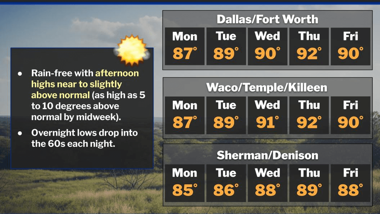
Absolutely nothing significant is expected over the next 7 days. We do have a little weather to discuss, though. A strong disturbance will move overhead today, producing extensive cloud cover and possibly scattered sprinkles showing up on radar. A few of these may reach the ground later this afternoon and evening, but most areas will remain dry. Due to the cloud cover, temperatures will be held down a few degrees, with highs in the mid to upper 80s. I refer to this as filtered sunshine.
As this disturbance shifts east overnight, we will return to sunny skies tomorrow through the rest of the week, as a mid-level ridge of high pressure builds across the area. The sinking air will contribute to our temperatures remaining above average for this time of year. Afternoon highs will be in the upper 80s Tuesday and Wednesday, near or slightly above 90 degrees on Thursday, Friday, and Saturday. Plenty of sunshine is expected.
This weather is perfect for the State Fair of Texas, but make sure to stay hydrated and wear light-colored, loose-fitting clothing, sunscreen, and a hat if you plan to visit Fair Park.
As of now, I see no major cold fronts until possibly the middle of next week, which is over 9 days away. That's when temperatures will most likely start to cool off, and rain chances may increase somewhat. Stay tuned throughout the week for updates.
Have a great work and school week, and please enjoy the weather when you can; it's the only weather you've got!
7-Day Headlines:
DFW hit 88 degrees on Sunday.
Increasing clouds today, a few sprinkles by evening.
Back to sunshine Tuesday.
Above average temperatures, below average rainfall.
No major change for a while.
Possible weather change in 10 days
*Yest Rain: 0.00"; Yest High: 88 Low: 66
*Today's Averages: High: 85; Low: 64
*Record high: 101 (2011); Record low: 46 (1967)
*September Rain: 1.11"; Deficit:
*2025 Rain: 28.16"; Surplus: 1.05"
*Sunrise: 7:22am; Sunset: 7:14pm
Monday: Increasing clouds and warm. A few sprinkles by late afternoon. High: Upper 80s. Wind: East 5 mph.
Monday night: Cloudy, with a few sprinkles. Mild. Low: Mid to upper 60s. Wind: East 5 mph.
Tuesday: Morning clouds, afternoon sunshine. High: Upper 80s. Wind: NE 5 mph.
Wednesday-Friday: Mostly sunny and warm. High: Near 90.
Weekend: Partly cloudy and warm. High: Upper 80s.
LISTEN on the Audacy App
Tell your Smart Speaker to "PLAY 1080 KRLD"
Sign Up to receive our KRLD Insider Newsletter for more news
Follow us on Facebook | Twitter | Instagram | YouTube


