Severe storms impacted western portions of southern North Texas yesterday. A cold front has shifted south of our location, but additional rainfall is anticipated later this afternoon and intermittently Thursday night and Friday, with potential flooding. Cooler weather has arrived and will persist throughout the weekend.
Good morning and welcome to Wednesday. My condolences go out to those who suffered damage from yesterday's storms. A possible tornado touched down in Mineral Wells, and significant hail was reported across parts of Palo Pinto, Parker, Hood, Johnson, and Hill counties. The largest reported hailstone measured 4.5 inches in diameter and was located between Godley and Cresson in northwestern Johnson County. Other reports indicated hail sizes ranging from golf balls to baseballs along the storm's path, west and south of Fort Worth.
Following the storm's passage, cooler air has moved in, and temperatures currently range from the low to mid-60s under considerable cloudiness. Today's forecast calls for cloudy and cool conditions, with highs remaining in the mid-60s and a north wind at 10 to 20 mph.
After 3:00 p.m., heavy rain will develop west of DFW and move across the area during the evening commute. Fortunately, this rainfall is not expected to be severe, although some pea-sized hail may be embedded within stronger storms. This rain will shift east of our location by midnight.
Thursday morning lows will hover near 60 degrees, with patchy drizzle possible. Most of Thursday will be dry, but rain will start moving in from the SW late in the afternoon and evening. A possible flood watch may be issued for Thursday night through Friday night. Temperatures will remain steady on Thursday, with highs in the low to mid-60s.
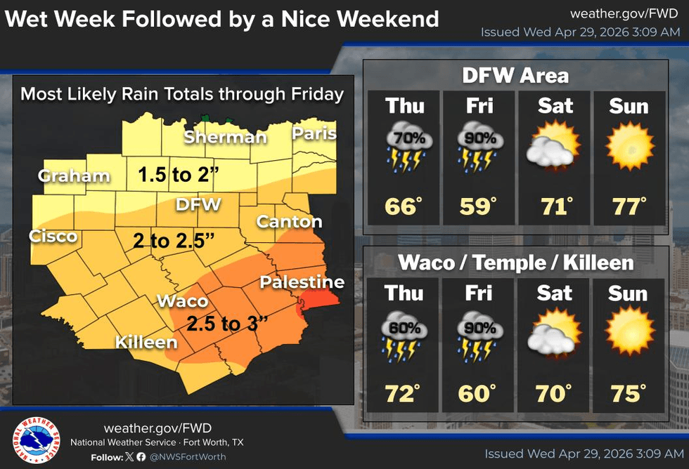
A strong upper-level disturbance will move out of northern Mexico and across central Texas on Friday, producing waves of heavy rain across North Texas. Average rainfall totals north of the I-20 Corridor will range from 1 to 3 inches, with lighter totals near the Red River. Heavier rain is expected south of I-20, with 3 to 5 inches possible, posing the highest flooding concern.
Temperatures will drop from the upper 50s in the morning to the lower 50s by dinner time, with gusty winds up to 30 mph, making for a cool and unpleasant day.
Sunshine will return this weekend, with highs near 70 on Saturday and morning lows dipping into the 40s. A warm-up will continue on Sunday, with highs in the mid to upper 70s, followed by temperatures near 80 on Monday and the mid-80s on Tuesday under partly cloudy skies.
I will continue to monitor the flooding potential on Friday. In the meantime, enjoy the cooler weather and the welcome early May rain
7-Day Headlines:
- DFW Airport reached 85 on Tuesday.
- Scattered showers today
- Heavy rain late Thursday into Friday
- Nothing severe
- 2 to 3 inches of rain through Friday night
- Threats: Flooding
- A beautiful weekend
- Download our AUDACY app. Listen to KRLD at home!
Almanac:
- Yest Rain: 0.65”; Yest High: 85; Low: 69
- Today’s Averages: High: 79; Low: 59
- Record high: 97 (1909); Record low 41 (1908)
- April rain: 4.99”; Surplus: 2.03”
- 2026 Rain: 10.15”; Snow: 2.4” Deficit: <1.40”>
- Sunrise: 6:42am; Sunset: 8:09pm
Forecast:
Wednesday: Cloudy and cooler.Scattered showers after lunchtime. High: Mid 60s. Wind: North 10-20 mph.
Wednesday night: Cloudy and cool. A few showers. Low: Near 60. Wind: NE 5-10 mph.
Thursday: Cloudy, breezy and cool. More rain by late afternoon, especially towards midnight. High: Low 60s. East 10-20 mph.
Friday: Cloudy, windy and cooler.Waves of heavy rain with some thunder. Rain totals: 2 to 4 inches. Heaviest south of I-20. Possible Flood Watch. High: Upper 50s early; low 50s by evening.
Saturday: Sunny and perfect! Low: Mid to upper 40s; High: Low 70s.
Sunday: Sunny and a bit warmer. Low: Low 50s; High: Mid 70s.
Monday: Partly cloudy and warmer. High: Near 80.
Tuesday: Partly cloudy and warm. High: Mid 80s.
LISTEN on the Audacy App
Tell your Smart Speaker to "PLAY 1080 KRLD"
Sign Up to receive our KRLD Insider Newsletter for more news
Follow us on Facebook | Twitter | Instagram | YouTube