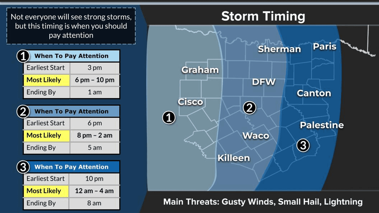

Stay weather aware of the flooding potential across parts of North Texas late this afternoon, especially this evening and overnight tonight. Another wave of rain — this time more widespread — will move from west to east later this evening through early Wednesday morning. Keep your umbrella handy.
More showers and storms remain in the forecast, mainly isolated during peak heating hours Wednesday through Saturday. Temperatures will climb into the 80s when the sun is out, but stay in the 70s where rain and clouds linger.
The most widespread rain is expected:
* Late this evening through Wednesday morning
* Then a break with morning clouds and afternoon sunshine Wednesday through Saturday
* Highs generally in the mid to upper 80s, especially Thursday through Sunday
Our next weather change may arrive during the second half of Sunday into early Monday next week. A cold front could slide into the area, although fronts this time of year sometimes stall before moving through. We’ll have to watch where it sets up.
There are also signs of upper-level support developing along and north of that boundary, which could bring another flooding concern late Sunday into Monday. It’s still several days away, so things can and likely will change, but it’s something we’ll continue monitoring closely.
Please stay weather aware this evening, especially if your area received heavy rainfall Sunday and Monday. Some locations around DFW, including parts of Collin County, picked up over 3 inches of rain.
Be careful out there, and enjoy the breaks in the weather when you can — it’s the only weather you’ve got!
7-Day Headlines:
- DFW Airport hit 88 degrees on Monday. Officially: 0.03” of rain
- Another round of storms on the way later today
- Widespread rain (8pm Tues-3am Wed), severity low, flooding potential
- Threats: Lightning, pockets of heavy rain, gusty wind
- Isolated afternoon and evening storms Thursday-Saturday
- More rain coming Sunday and Monday
- 70s in the rain, 80s in the sun
- Download our AUDACY app. Listen to KRLD at home
Almanac:
- Yest Rain: 0.03”; Yest High: 88; Low: 66
- Today’s Averages: High: 87; Low: 68
- Record high: 99 (1908); Record low 50 (1901)
- May rain: 2.55”; Deficit: <01.33”>
- 2026 Rain: 12.77”; Snow: 2.4” Deficit: <2.92”>
- Sunrise: 6:22am; Sunset: 8:29pm
Forecast:
Tuesday: Partly cloudy, warm and humid. Isolated afternoon storms. High: Mid to upper 80s. Wind: ESE 5 mph.
Tuesday night: Cloudy with showers and storms (8pm-3am). Isolated severe. Threats: Heavy rain, lightning, small hail, gusty wind. Low: Mid 60s. Wind: SE 5-10 mph.
Wednesday: Mostly to partly cloudy, warm and humid. Isolated late day showers and storms. High: Low to mid 80s. WInd: South 5-10 mph.
Thursday - Saturday: Mostly to partly cloudy, warm and humid. Isolated late day showers and storms. Highs: Mid to upper 80s.
Sunday: Mostly to partly cloudy, warm and humid. Scattered showers and storms. Cold front late? Highs: Mid to upper 80s.
Monday: Mostly cloudy. A bit cooler. Scattered showers and storms. High: Near 80.
LISTEN on the Audacy App
Tell your Smart Speaker to "PLAY 1080 KRLD"
Sign Up to receive our KRLD Insider Newsletter for more news
Follow us on Facebook | Twitter | Instagram | YouTube