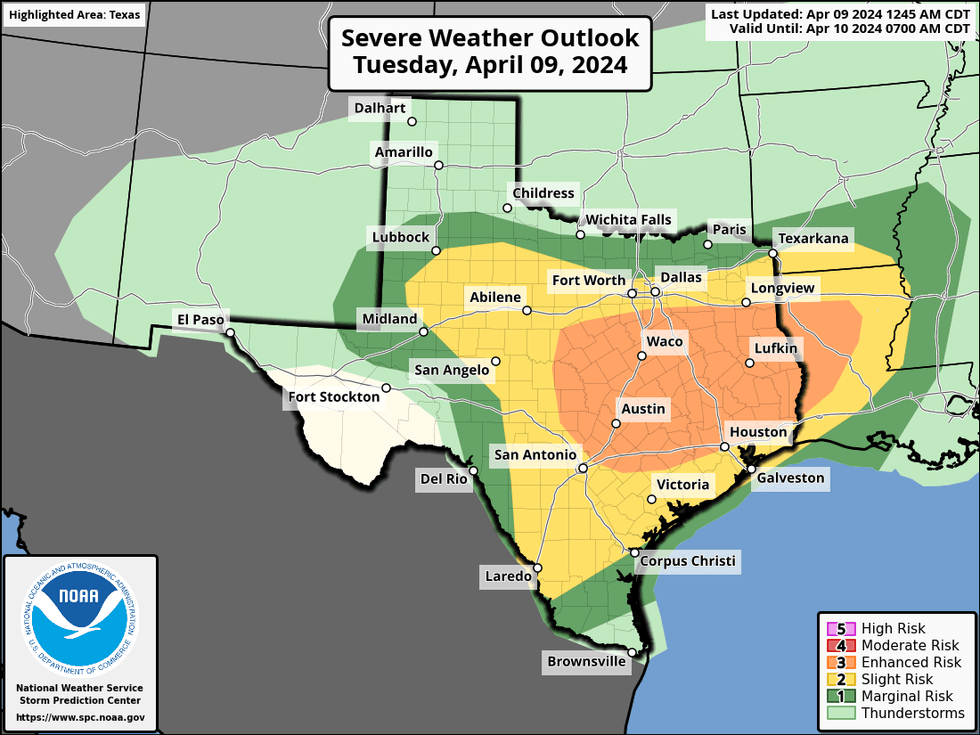
The National Weather Service issued a Tornado Watch Tuesday for Henderson, Navarro, and other counties south and east of the Dallas-Fort Worth area until 5 p.m.
A Flood Watch remains in effect for Anderson, Delta, Henderson, Hunt, Kaufman, Lamar, Navarro, Rains, Van Zandt, and other counties until Wednesday morning.
Numerous rain showers and storms will redevelop by mid-morning Tuesday and continue through the day. Some may become severe, especially south of Interstate 30. One more wave of showers and storms will move through Wednesday, and then the weather gets better Thursday into the weekend.
A wave of showers and storms Monday night moved off to the east of Dallas-Fort Worth, but some areas picked up over 3 inches of rain. Officially, DFW Airport measured 0.70 inches of rain.
The next spoke of energy will cross the area late Tuesday morning, through this afternoon and evening, sparking more showers and thunderstorms.
 NOAA
NOAA
Large hail and damaging wind will be the main threats, but an isolated tornado cannot be ruled out. Flooding will also be a concern for areas that have already seen rain. Afternoon highs will reach near 70 degrees Tuesday.
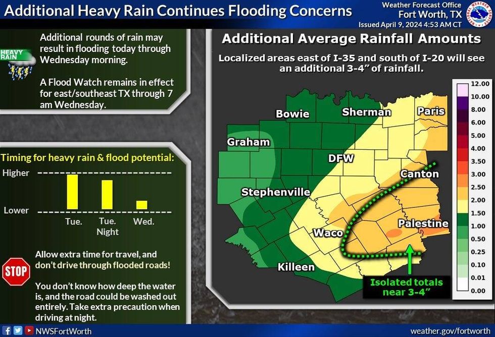
We'll get a brief break in the rain overnight Tuesday into early Wednesday before the whole system swings through the area during the day. Another area of showers and storms will develop along the upper-level disturbance. I'm not concerned about severe weather, but small hail and some brief gusty winds are possible. Additional rainfall today and tomorrow will range between 1-3 inches.
 National Weather Service - Fort Worth
A cold front will sweep through the area Wednesday morning, holding temperatures in the mid to upper 60s. Again we will have that rain around until mid to late afternoon.
Thursday through Sunday looks fantastic. Plenty of sunshine Thursday and Friday with highs in the low 70s Thursday, upper 70s Friday. Increasing high clouds into the weekend, breezy and warm. Low 80s on Saturday, mid to upper 80 on Sunday. A slight rain chance returns Monday with highs in the mid 80s.
*Yest Rain: 0.05"; Yest High: 82; Low: 53
*Today's Averages: High: 75; Low: 54
*Record high: 97 (1963); Record low: 30 (1914)
*March Rain: 0.57"; Deficit: 0.21"
*2024 Rain: 11.37"; Surplus: 2.00"
*Sunrise: 7:05am; Sunset: 7:54pm
LISTEN on the Audacy App
Tell your Smart Speaker to "PLAY 1080 KRLD"
Sign Up to receive our KRLD Insider Newsletter for more news
Follow us on Facebook | Twitter | Instagram | YouTube