Monday begins with temperatures in the mid to upper sixties with some patchy fog around. I'm also tracking a cold front that's working its way through the Panhandle right now. This front will arrive in north Texas late this afternoon into the evening.
This coupled with an upper level of disturbance moving in for the southwest will promote scattered showers and storms, but nothing severe is expected. As of now, it looks like the more widespread rain will stay to the south of DFW. Rain will end from north to south by late evening and be confined to central Texas through the overnight hours.
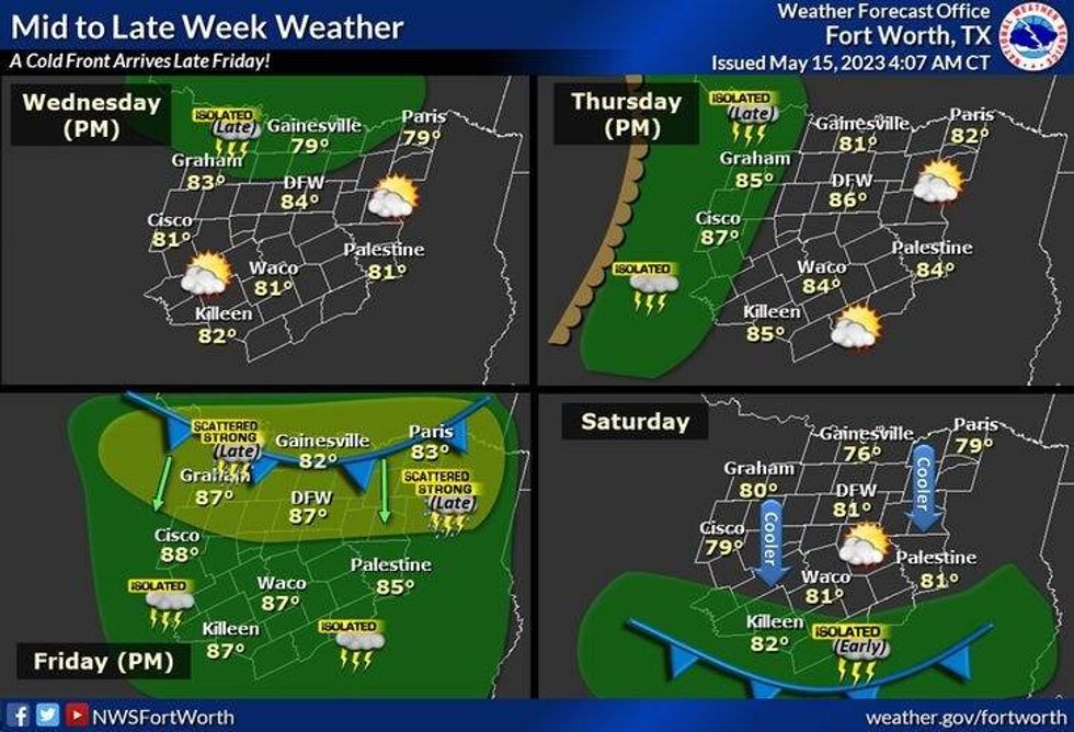
Slightly drier air will work its way into the area tomorrow and Wednesday. Partly cloudy skies with a high near 80 tomorrow, low eighties on Wednesday with a few isolated storms along the red river by evening.
 National Weather Service - Fort Worth
A warm front moves in from the south on Thursday, increasing the humidity, bringing a slight chance of showers and storms, mainly west of DFW, by evening. Afternoon highs will reach the mid eighties.
Friday's weather looks decent most of the day, with high temperatures in the mid two upper eighties. By Friday evening, our next cold front arrives, increasing our storm chances. A few may be strong or severe.
Behind the front, cooler-drier air will filter in just in time for the weekend. All of us will enjoy plenty of sunshine with highs in the mid to upper seventies.
*Yest Rain: 0.44"; Yest High: 75; Low: 69
*Today's Averages: High: 83; Low: 64
*Record high: 97 (2022): Record low: 44 (1907)
*May Rain: 1.07"; Deficit: 1.07"
*2023 Rain: 12.30"; Deficit: 1.65"
*Sunrise: 6:28am; Sunset: 8:21pm
Today: Patchy morning fog and a few showers, then mostly cloudy through the day with late afternoon and evening showers and storms. High: Mid 80s. Wind: West 5-10 mph.
Tonight: Mostly cloudy and pleasant. Showers and storms press to our south. Low: Low to mid 60s. Wind: NW 5-10 mph.
Tomorrow: Partly cloudy and nice. Lower humidity. High: Near 80.
Wednesday: Mostly to partly cloudy and warm. Isolated late day storms to the north (Red River area) of DFW. Highs: Low 80s.
Thursday: Mostly to partly cloudy and warm. Isolated late day storms to the west of I-35W. High: Mid 80s.
Friday: Increasing clouds by late afternoon and warm. Scattered showers and storms by evening along our next cold front. High: Mid 80s.
Weekend: Mostly sunny, cooler with lower humidity! Highs: Mid to upper 70s.

LISTEN on the Audacy App
Tell your Smart Speaker to "PLAY 1080 KRLD"
Sign Up to receive our KRLD Insider Newsletter for more news