A conditional risk for severe storms later today, widespread heavy rain and non-severe storms on Saturday, a decent Sunday, rain returns Monday, and severe weather possible next Tuesday.
It's Friday, ladies and gentlemen! A very active weather pattern is commencing across North Texas once again. Although it won't rain every day for the next seven days, we have several chances for showers and strong to severe thunderstorms through next Wednesday.
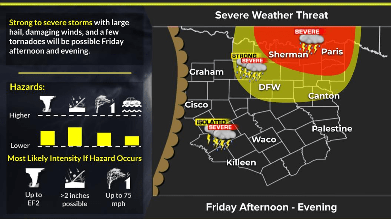
Good morning. We're waking up to temperatures in the 60s this morning under a mostly cloudy sky. There are a few sprinkles around, but they're not amounting to much. Today, elevated showers and a few rumbles of thunder will break out after the noon hour and stream in from the south. Breezy south winds will gust to 30 mph as a dry line approaches from the west later this afternoon into the early evening hours. That being said, a conditional risk for severe weather is in the forecast this evening, dependent on if the cap breaks. If it does, storms will develop rapidly along the dry line as it moves into the area this evening. Very large hail, damaging wind, and an isolated tornado would be possible if any storms do form. The Storm Prediction Center has put areas along and north of Interstate 20 at a level two or slight risk for severe weather this evening. I'll definitely keep an eye on the situation and jump on NewsRadio 1080 KRLD AM if necessary.
Saturday's forecast is different, with a cold front moving into the area before 9:00 a.m., bringing widespread shower and thunderstorm activity along and behind the front. As of now, the severity looks very low, but heavy rain is a bit concerning, especially in areas that saw too much rain recently. Flash flooding could be a concern in those areas as we work our way through the day. Severity looks to remain very low.
A different story for severe weather across the southeastern half of the state, where there will be more instability and heating for these storms to feed off of. Temperatures will start off in the upper 60s tomorrow morning and slowly fall into the 50s by dinner time. North winds will gust to 25 mph, creating a pretty lousy day. Don't get me wrong, we do need the rain.
As of now, Sunday looks pretty decent, but it will remain mostly cloudy throughout the day. Temperatures will struggle to get out of the low 60s. If we see more sunshine, we'll warm up to near 70. The cold front that moves through Saturday will lift back to the north on Monday, creating a few scattered showers and storms across the area. Temperatures will warm back into the upper 70s.
A very strong storm system will be heading into the area on Tuesday. Widespread shower and thunderstorm activity will break out and move in from the west. I can't rule out severe weather by late afternoon and evening, with all modes of severe weather possible. I'll keep an eye on the speed, track, and strength of the system and update this forecast into early next week. Temperatures will be in the mid-70s for highs.
A lingering shower or storm is possible on Wednesday as the upper-level disturbance crosses overhead. High temperatures will be in the low to mid-70s. Improving weather is expected on Thursday, with readings near 70 degrees as the air dries out.
I'll be keeping an eye on things this evening and then again tomorrow as a very active weather pattern slowly unfolds. Please have multiple ways to receive warnings and tune into NewsRadio 1080 KRLD AM and this page for live updates as conditions warrant.
Have a great day today, a wonderful weekend, and enjoy the weather when you can, as it's the only weather you've got.
7-Day Headlines:
* DFW Airport reached 82 yesterday.
* 9 days in a row with highs in the 80s.
* Conditional risk for severe weather Friday evening (strong cap).
* Threats: Hail, wind, and isolated tornadoes.
* Flooding threat returns Saturday. Nothing severe in North Texas.
* Sunday will be decent!
* More storms Monday; some severe next Tuesday.
*Yest Rain: 0.00"; Yest High: 82; Low: 65
*Today's Averages: High: 66; Low: 45
*Record high: 9o (1916, 1929); Record low 20 (1989)
*March rain: 1.55"; Surplus: 1.13"
*2026 Rain: 3.79"; Snow: 2.4" Deficit:
*Sunrise: 6:48am; Sunset: 6:30pm
Friday: Mostly to partly cloudy, windy and mild. Isolated morning showers, then scattered afternoon showers and non-severe storms. High: Near 80. Wind: South 15-25, G30 mph.
Friday night: Isolated evening severe storms north of I-20 (strong cap in place). Threats: Large hail, damaging wind, an isolated tornado. Low: Upper 60s. Wind: South 15-25 mph.
Saturday: Morning cold front. Widespread showers and non-severe storms throughout the day. 1.00"-3.00" on the way. Flash flooding is a concern south and east of DFW. High: falling into the 50s by noon. Wind: North 10-20 mph.
Saturday night: Showers and storms press to our south. Cooler. Low: 46-53.
Sunday: Some clearing from north to south. High: Mid to upper 60s.
Monday: Cold front lifts north. Mostly cloudy, breezy and warmer. Isolated showers and storms. High: Upper 70s.
Tuesday: Increasing clouds, breezy and mild. Strong to severe storms are possible late in the day. High: Mid to upper 70s.
Wednesday: Mostly cloudy and mild. A few leftover showers and storms. High: Mid 70s.
Thursday: Decreasing clouds, breezy and cooler. Lower humidity. High: Low 60s.
LISTEN on the Audacy App
Tell your Smart Speaker to "PLAY 1080 KRLD"
Sign Up to receive our KRLD Insider Newsletter for more news
Follow us on Facebook | Twitter | Instagram | YouTube