Following a turbulent evening across parts of North Texas, additional rough weather is anticipated, albeit not until late Tuesday.
We are waking up to a predominantly cloudy sky with extremely muggy air in place on this Monday morning. Temperatures are in the mid-70s. It is advisable to keep your umbrella handy, as it will be needed intermittently over the next few days. Scattered showers are expected to develop across the area before noon, which will dissipate shortly thereafter. Afternoon highs will be warm and muggy today, with readings reaching approximately 90 degrees. Heat index values will approach 100 degrees. It is essential to stay hydrated.
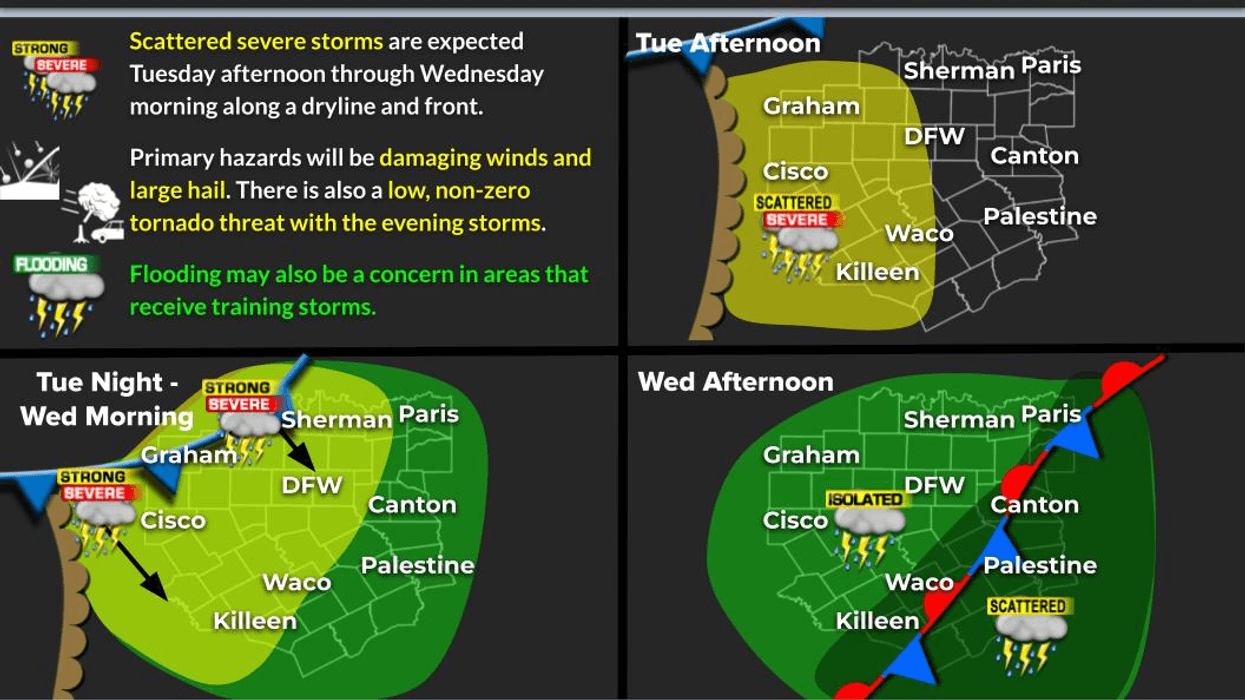
We will commence Tuesday morning under a cloudy sky, with temperatures in the low to mid-70s once again. Most areas will experience some sunshine Tuesday afternoon, with high temperatures nearing 90 degrees. Heat index values will approach 100 degrees. By late Tuesday afternoon, storms will rapidly form to the northwest, stretching from Oklahoma City to Wichita Falls to Abilene. These storms will become severe, characterized by large hail, damaging winds, and isolated tornadoes. The individual cells will consolidate into a large complex and move southeast through the evening hours. Most of DFW will experience beneficial rain; however, some storms will remain severe, with hail and wind being the primary threats. Isolated tornadoes cannot be ruled out due to surface winds at 10 to 20 mph.
Storms will shift south and east of us Wednesday morning and may regenerate in these areas by afternoon into the evening hours. It is likely that most areas will remain dry on Wednesday. Afternoon highs will be significantly cooler, struggling to reach 80 degrees, with cooler temperatures north and west.
This front will lift back to the north on Thursday. Scattered afternoon and evening storms cannot be ruled out, but most areas will remain dry. Afternoon highs will gradually increase into the upper 80s.
Morning clouds and afternoon sunshine are expected for Friday through the weekend, accompanied by ample warmth. As of now, most precipitation is anticipated to remain in Oklahoma on Friday and Saturday but may return to the area on Sunday with our next slow-moving front. Temperatures will be at or above 100 degrees this weekend.
I will continue to monitor the weather for you throughout the week. Have a great day and enjoy the weather when you can, It's the only weather you've got!
7-Day Headlines:
DFW hit 89 degrees on Tuesday.
A few Monday morning showers.
West Texas severe storms later today.
Increasing storm chances late Tuesday into Wednesday.
Threats: Large hail, damaging wind, isolated tornadoes.
Isolated storms Thursday – Saturday.
Scattered storms return late Sunday.
*Yest Rain: 0.00"; Yest High: 89 Low: 70
*Today's Averages: High: 89; Low: 70
*Record high: 104 (1910): Record low: 52 (1919)
*June Rain: 0.00"; Surplus: 0.00"
*2025 Rain: 18.44"; Surplus: 1.72"
*Sunrise: 6:20am; Sunset: 8:33pm
Monday: A few morning showers, then partly cloudy, warm and humid. High: Near 90. Heat index: near 100 degrees. Wind: South 10-20 mph.
Monday night: Partly cloudy, breezy and mild. Low: Low to mid 70s. Wind: South 10-20 mph.
Tuesday: Morning clouds, afternoon sunshine. Scattered late afternoon and evening showers and storms. Some severe. Threats: Large hail, damaging wind, isolated tornadoes. High: Near 90. Wind: South 15-25 mph.
Wednesday: Scattered showers and storms. High: Near 80.
Thursday - Saturday: Morning clouds, afternoon sun. Isolated late day storms. Highest chance well north of DFW. Highs: 88-94. Hottest on Saturday.
Sunday: Morning clouds, afternoon sun. Hot and humid. Scattered late day storms. High: Mid to upper 90s.
LISTEN on the Audacy App
Tell your Smart Speaker to "PLAY 1080 KRLD"
Sign Up to receive our KRLD Insider Newsletter for more news
Follow us on Facebook | Twitter | Instagram | YouTube