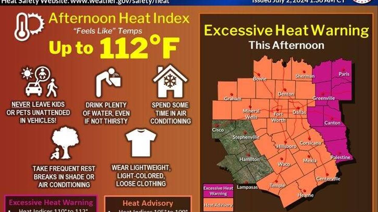
More Heat Advisories are in place Tuesday with surface temperature reaching 102 degrees and heat index values between 105 and 109. Excessive Heat Warnings for heat index values above 110 will plague East Texas.
There are not any changes in the forecast through Thursday. North Texas will likely have Heat Advisories in place once again with an afternoon high on Wednesday around 101 degrees, and 100 degrees on Thursday with more cloud cover.
The first weather change arrives late Thursday night into Friday as a rare July cold front sags into the area. It looks like the fireworks shows will be OK Thursday evening across North Texas, but radar will need to be monitored along the Red River counties for possible storms sneaking into the area after 9 p.m. This front will be right on top of this area on Friday producing scattered showers and storms. Gusty wind, dangerous lightning, and brief heavy rainfall will be the threats. It will be cooler as well with afternoon highs struggling to get above 90 degrees.
The weekend forecast is dependent on where this stalled front lays. More scattered showers and storms will form along this boundary on Saturday before it lifts to the north of Dallas-Fort Worth on Sunday. Afternoon highs will range between 90 and 95 depending on how much sunshine there is. Most of the storm coverage will be south of DFW on Saturday spreading back to the north on Sunday. Another cold front may flirt with us on Monday bringing more scattered storms back to the area. High temperatures will hover near 90 degrees.
All eyes are on Hurricane Beryl, especially by late into the weekend and into next week. It's still way too early to tell you if we'll see any impacts from Beryl across North Texas.
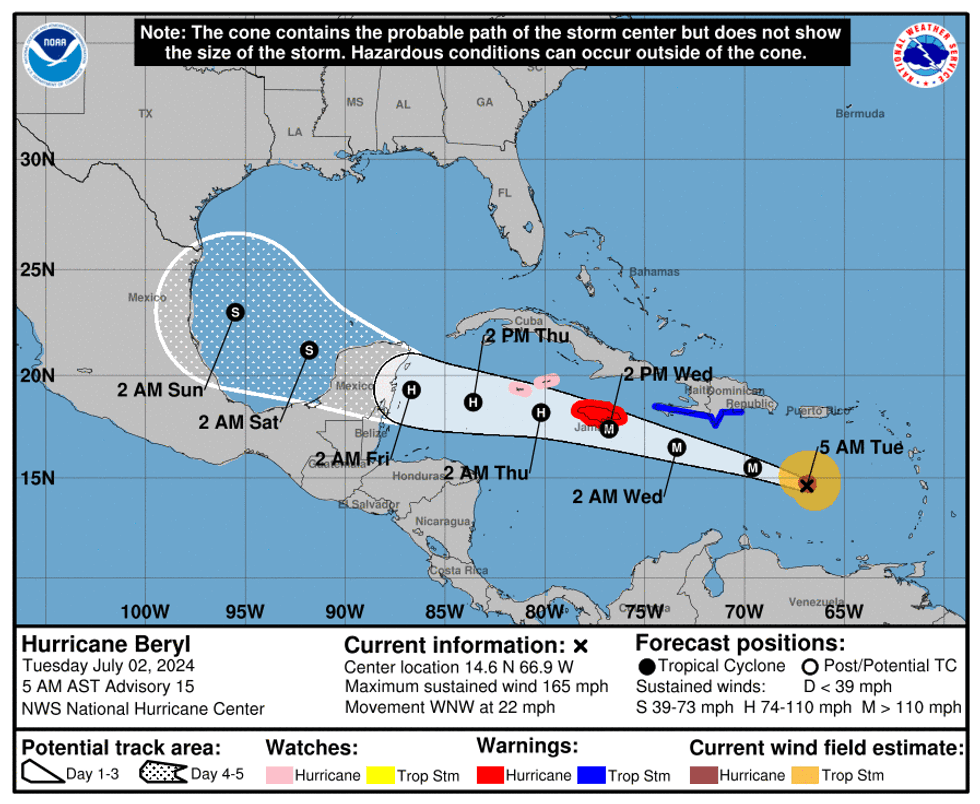 Hurricane Beryl trackNOAA
7-Day Headlines
* DFW Airport reached 100 on Monday. 3rd triple digit temperature this year.
* Earliest known Atlantic Cat 5 Hurricane Beryl reaches 165 mph wind.
* Heat Advisories Tuesday and Wednesday. Heat indices 105+.
* Stalling Friday cold front brings storms and cooler temperatures.
* Scattered storms this weekend.
* Watching Beryl's track next week.
________________________________________________________
*Monday Rain: 0.00"; Monday High: 100; Low: 83
*Tuesday's Averages: High: 94; Low: 75
*Record high: 110 (1980); Record low: 65 (1924, 1943)
________________________________________________________
*June Rain: 3.67"; Deficit:
*2024 Rain: 28.74"; Surplus: 8.34"
*Sunrise: 6:24am; Sunset: 8:40pm
________________________________________________________
Tuesday: *Heat Advisory* Mostly sunny and hot. High: 102. Heat index: 105+. Wind: SSW 10-20 mph.
Tuesday night: Clear, breezy, warm, and muggy. Low: Low 80s. Wind: SE 15-25 mph.
Wednesday: *Heat Advisory* Mostly sunny and hot. High: 101. Heat index: 105+. Wind: SE 10-20 mph.
Thursday: Partly cloudy and hot. Scattered storms move in from Oklahoma towards midnight. High: Near 100.
Friday – Sunday: Partly to mostly cloudy and cooler. Stalling cold front brings scattered storms to north Texas. Highs: 90-95.
Monday: Partly to mostly cloudy. Watching Beryl. High: Near 90.
 Rain chances for North Texas on Friday and Saturday, July 5-6, 2024.National Weather Service
LISTEN on the Audacy App
Tell your Smart Speaker to "PLAY 1080 KRLD"
Sign Up to receive our KRLD Insider Newsletter for more news
Follow us on Facebook | Twitter | Instagram | YouTube