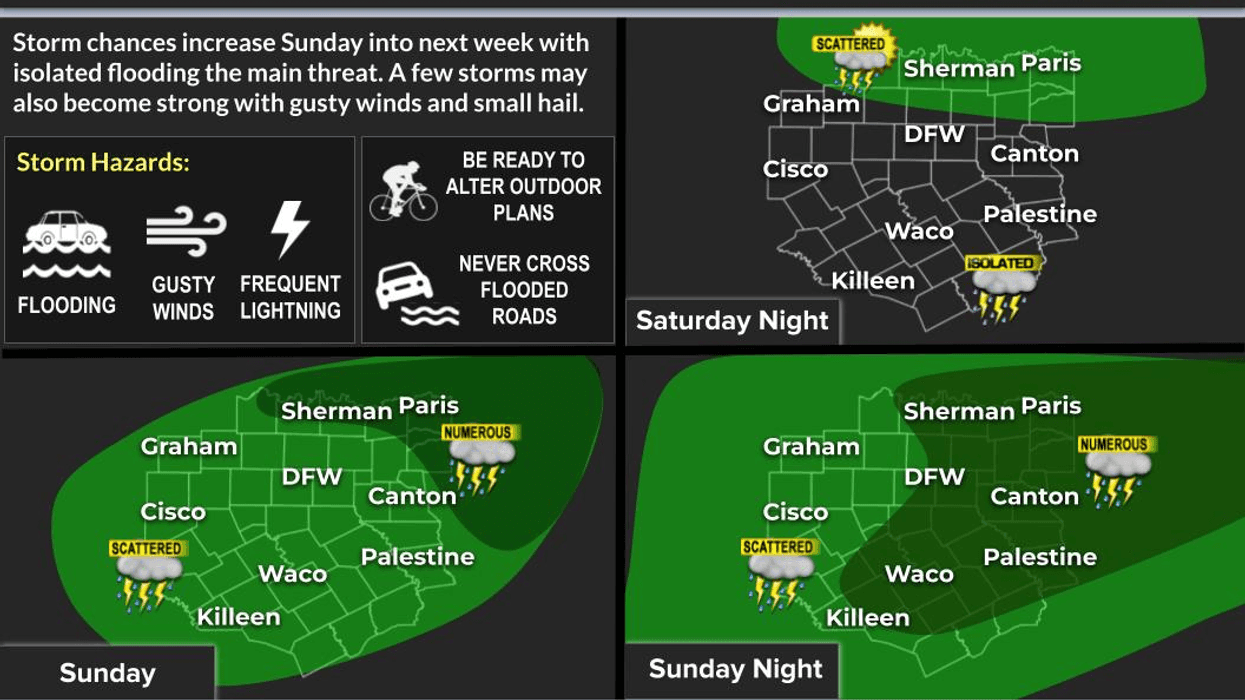

Weather changes are finally on the way across North Texas as we head into the weekend and through the middle of next week. The upper-level ridge of high pressure that's been keeping us hot and dry will begin shifting north, allowing more easterly flow in the upper atmosphere. That will open the door for a few disturbances to move across Texas, and a weak boundary is expected to slide south of Interstate 20 by Tuesday and Wednesday. As that happens, scattered showers and thunderstorms will return to the forecast.
Good morning, everyone! Welcome to Friday...and payday for some of you!
We're waking up to warm temperatures with a few low clouds trying to sneak in from the south. This afternoon we'll climb back to around 100 degrees with a south wind at 10 to 20 mph.
As we head into the weekend, expect a few morning clouds on Saturday before afternoon sunshine pushes temperatures back into the upper 90s. A few isolated showers and storms may try to move in from the south, but I don't think they'll make it. We'll also keep an eye on a few storms developing over Oklahoma, but those should remain north of us.
By Sunday and Monday, scattered afternoon and evening showers and thunderstorms return to the forecast. High temperatures will ease back into the mid-90s Sunday and the lower 90s Monday and Tuesday.
Right now, Tuesday and Wednesday look like the best chance for scattered storms to stay mainly south of the Dallas-Fort Worth area, but keep in mind that's still five to six days out, so the forecast is certainly subject to change. This shield may shift farther north to include DFW. Stay tuned.
The bottom line: cooler temperatures are on the way by late this weekend and early next week, along with increasing rain chances. That's some great news after this stretch of triple-digit heat.
Have a great Friday, enjoy your weekend, and enjoy the weather when you can...it's the only weather you've got!
7-Day Headlines:
* DFW Airport reached 101 on Thursday
* Three triple digit temperatures this summer, 20 is average
* Flirting with 100 degrees through Sunday
* Scattered storms return Sunday - Tuesday
* A bit cooler early next week
* Please download our Audacy app. Listen to NewsRadio 1080am live anytime/anywhere
Almanac:
*Yest Rain: 0.00”; Yest High: 10; Low: 81
*Today’s Averages: High: 95; Low: 75
*Record high: 107 (1917); Record low 56 (1905)
*July rain: 0.00”; Surplus: <0.86”>
*2026 Rain: 21.25”; Snow: 2.4” Surplus: 0.10”
*Sunrise: 6.28am; Sunset: 8:39pm
Forecast:
Friday: Morning clouds, afternoon sun. Breezy and hot. High: Near 100. Heat index: Near 105. Wind: South 10-20, G25 mph.
Friday night: Increasing clouds by daybreak. Breezy, mild and muggy. Low: Near 80. Wind: South 10-15 mph.
Saturday: Morning clouds, afternoon sun. Breezy and hot. High: Near 100. Heat index: Near 105. Wind: South 10-15 mph.
Sunday: Morning clouds, afternoon sun. Still hot. Scattered late day showers and storms. High: Mid to upper 90s. Heat index: Near 103.
Monday: Partly cloudy. Not as hot. Scattered showers and storms. High: Low 90s. Heat index: Upper 90s.
Tuesday: Partly cloudy and warm. Scattered showers and storms. Highest chance south of DFW. High: Low 90s.
Wednesday: Partly cloudy and hot. Isolated late day showers and storms. High: Mid 90s.
Thursday: Mostly sunny and hot. High: Mid 90s.
LISTEN on the Audacy App
Tell your Smart Speaker to "PLAY 1080 KRLD"
Sign Up to receive our KRLD Insider Newsletter for more news
Follow us on Facebook | Twitter | Instagram | YouTube