Good morning and welcome to Monday!
It's the first full week of summer, and I hope everyone had a great Father's Day weekend. Now it's back to work we go, and there are some storms to deal with this morning.
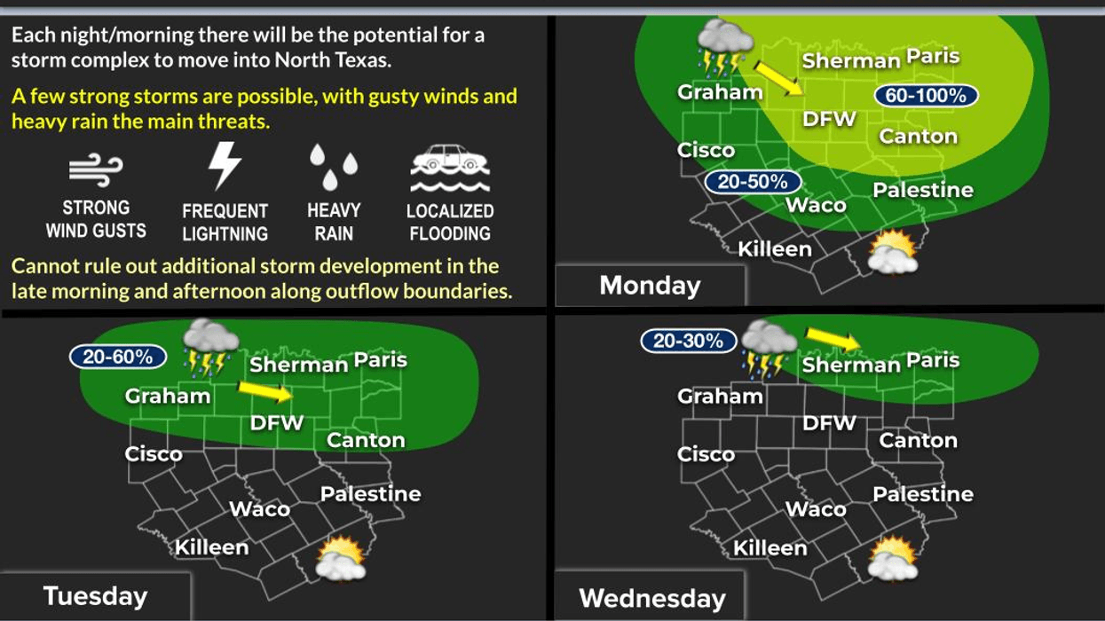
A Severe Thunderstorm Watch remains in effect until 11:00 a.m. for our northern counties, mainly along and north of Highway 380. I think the strongest winds will shift into Northeast Texas over the next few hours, but don't be surprised if you encounter a few rumbles of thunder and wet roadways during the morning commute, especially if you're traveling in from the north side of the Metroplex through about 9:00 a.m.
This afternoon, a stalled cold front near the Red River could spark a few additional scattered showers and thunderstorms. Most of that activity should remain along and north of Highway 380. Temperatures will climb into the lower 90s, but with the humidity, it'll feel much closer to 100 degrees.
Looking ahead, it's more of the same Tuesday and Wednesday. We'll continue to watch for a few rounds of morning thunderstorms moving in from the north, especially Wednesday morning. At this point, widespread severe weather is not expected, but we'll keep a close eye on things. Morning lows will remain in the 70s, with afternoon highs in the low to mid-90s.
By Thursday and especially into the weekend, a strengthening ridge of high pressure currently baking the western third of Texas will begin expanding eastward into North Texas. As that happens, rain chances will diminish and temperatures will start heading upward.
In fact, by late week and next weekend, we'll likely be talking about the return of Heat Advisories. Afternoon heat index values could climb into the 105° to 110° range, and we're going to be watching closely to see if North Texas reaches 100 degrees for the first time this summer.
Summer just started, but the hottest stretch of weather so far may be right around the corner. Stay tuned!
Stay cool, stay hydrated, and enjoy the weather when you can—that's the only weather you've got!
– Dan the Weatherman
7-Day Headlines:
- DFW Airport hit 92 degrees on Monday
- Morning Severe Storm Watch north. Threats: Wind, lightning
- Scattered afternoon Monday storms, north of DFW
- Morning storms north, Tuesday and Wednesday
- Drying out Thursday - Sunday
- Possible heat Advisories. Heat index 105+
- Mosquitoes and humidity dominate
- Download our AUDACY app. Listen to KRLD at home
Almanac:
- Yest Rain: 0.00”; Yest High: 92; Low: 56
- Today’s Averages: High: 93; Low: 73
- Record high: 103 (1936, 1953); Record low 58 (1902)
- June rain: 8.07”; Surplus: 5.41”
- 2026 Rain: 21.25”; Snow: 2.4”; Surplus: 2.00”
- Sunrise: 6:19am; Sunset: 8:40pm
Forecast:
Monday: * Severe Storm Watch (north of DFW) until 11am * Morning strong storms (north of DFW), afternoon heat and humidity. Scattered afternoon and evening storms. High: Low to mid 90s. Wind: SE 10-20 mph.
Monday night: Partly cloudy and humid. Low: Mid to upper 70s. Wind: South 10-15 mph.
Tuesday: Isolated morning storms NE of DFW, afternoon heat and humidity. High: Low 90s. Heat index: Near 100. Wind: South 10-20 mph.
Wednesday: Morning storms, afternoon sun, heat and humidity. High: Low to mid 90s. Heat index: Near 105.
Thursday and Friday: Partly cloud, hot and humid. Highs: Mid 90s. Heat index near 105.
Weekend: Mostly sunny, breezy, hot and humid. Highs: Upper 90s. Heat index: 105+ Possible Heat Advisories!
LISTEN on the Audacy App
Tell your Smart Speaker to "PLAY 1080 KRLD"
Sign Up to receive our KRLD Insider Newsletter for more news
Follow us on Facebook | Twitter | Instagram | YouTube