


We're starting off Tuesday with temperatures near sixty degrees this morning with plenty of cloud cover. Scattered showers will start to develop across north Texas by late morning through the afternoon. High temperatures will reach seventy degrees.
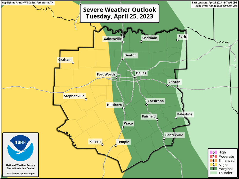
A warm front will cruise through the area tonight bringing a chance for scattered strong storms. As of now, the severe weather threat will stay west and NW of DFW. Morning lows will dip to near sixty degrees again.
 National Weather Service - Fort Worth
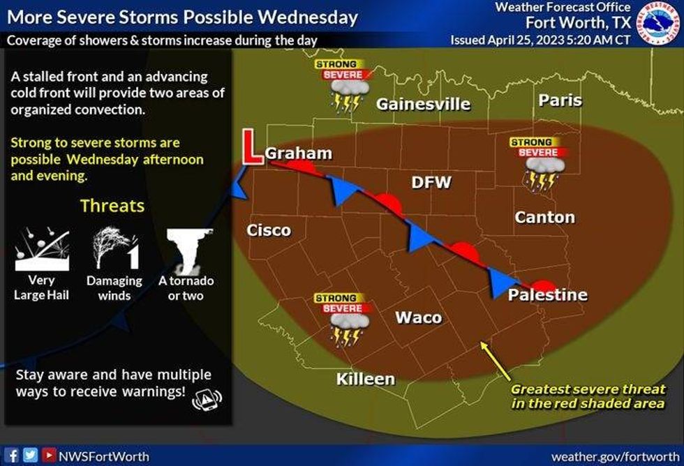
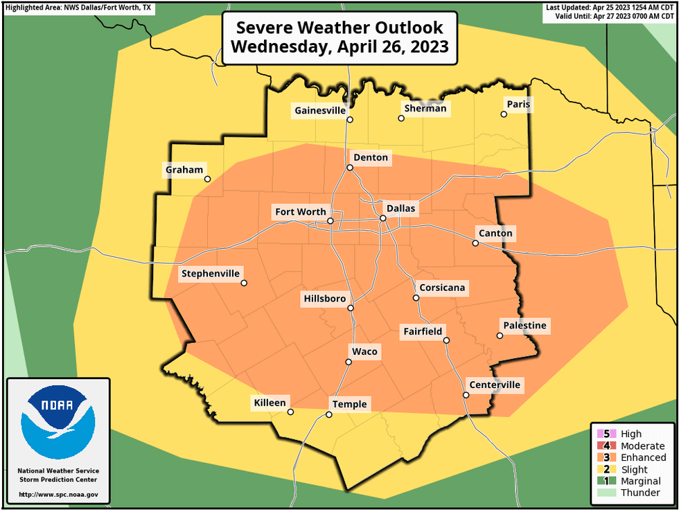
There will be a few showers and storms around tomorrow morning through the early afternoon, but things really start ramping up after dinner through midnight, as all modes of severe weather are possible.We do have a level 3 at a 5 for severe weather during this time frame. A cold front will sweep through the area late tomorrow evening pushing the inclement weather to our south and east. It will turn windy and cooler by Thursday morning, with decreasing clouds. Morning lows will dip into the low fifties with afternoon highs on Thursday near seventy degrees.
 National Weather Service - Fort Worth
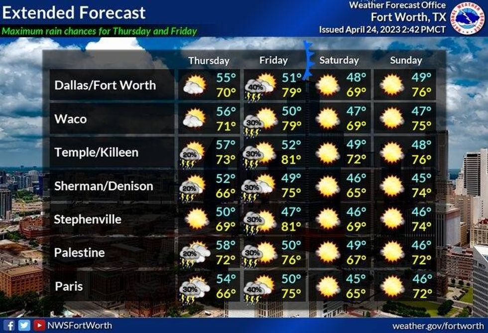
Most of Friday is uneventful until late evening, as another cold front approaches.There is a chance for a few scattered showers and storms along the front. As of now, the severe weather threat remains low, but this could change as we get closer to Friday evening. I will continue to keep you updated.
We can thank this cold front Friday evening for a beautiful weekend! It will be sunny, windy and cool on Saturday with highs in the upper sixties. A quick warm up into Sunday, with highs in the upper seventies. Monday looks nice, but a bit windy with highs in the low eighties..
 National Weather Service - Fort Worth
Yest Rain: 0.00"; Yest High: 70 Low: 45
*Today's Averages: High: 78; Low: 58
*Record high: 91 (1902, 1925); Record low: 32 (1910)
*April Rain: 1.64"; Deficit: 0.83"
*2023 Rain: 9.75"; Deficit: 1.31"
*Sunrise: 6:47am; Sunset: 8:06pm
Today: Mostly cloudy and mild with a chance of scattered showers. High: Near 70. Wind: ESE 10-20 mph.
Tonight: Cloudy and mild. Scattered showers and storms. Severe threat stays west of DFW. Low: Near 60. Wind: SE 10-20 mph.
Wednesday: Mostly cloudy and warmer. A few showers and storms through the afternoon. Severe threat ramps up by late afternoon and evening. Level 3 (Enhanced) out of 5 for all modes of severe weather. Threats: Large hail, damaging wind, isolated tornadoes. Cold front by late evening. High: Upper 70s. ESE 10-20 mph.
 National Weather Service - Fort Worth
Thursday: Sunny, breezy and cooler. High: Near 70.
Friday: Partly cloudy and warmer. A slight chance of showers and storms by evening. High: Low 80s.
Saturday: Sunny, windy and cooler. High: Upper 60s.
Sunday: Mostly sunny and a bit warmer. High: Upper 70s.
Monday: Mostly sunny, windy and warm. High: Low 80s.

LISTEN on the Audacy App
Tell your Smart Speaker to "PLAY 1080 KRLD"
Sign Up to receive our KRLD Insider Newsletter for more news


