Our perfect weather pattern will slowly come to an end by the end of the week, humidity levels will increase, and so will the wind, temperatures, and storm chances especially from Friday into the weekend.
A south wind is back and it will be rather gusty through the weekend. South winds are warming winds and also cause humidity levels to rise. You normally can't see the humidity but indirectly, low clouds are a decent sign that the atmosphere is thickening up.
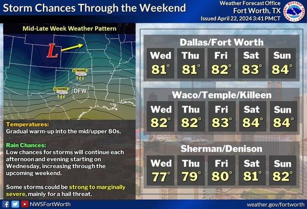
There will be plenty of sunshine today with highs approaching 80°. I'm also going to keep an eye on a weak cold front that'll go stationary along the Red River Valley today and tomorrow. This boundary will produce some scattered strong to severe storms to the northwest of DFW each afternoon. Some of those will try to sneak toward the I-35W corridor, but I think they'll die out as they do so. Hail and wind will be the threats northwest of the Dallas-Fort Worth area. High temperatures will warm into the low 80s tomorrow.
 National Weather Service - Fort Worth
By Thursday, the dryline will activate to the west of the Dallas-Fort Worth area. Storms will head east, but once again may die out as they approach DFW. Highs will be in the low 80s again.
The dryline will be much closer to us Friday morning and it will surge across the area during the afternoon. Scattered showers and storms will develop along this boundary. Large hail and damaging wind will be the primary threat, but an isolated tornado cannot be ruled out. Highs once again will be in the low 80s.
Our next system, still over the open water of the Pacific Ocean, will head into the south central plains states late Saturday into Sunday. It'll drag a weak Pacific cold front across the area. This boundary will produce scattered showers and storms late Saturday into Sunday. Some of these storms may become severe. All modes of severe weather will be possible. We're still days away and I will continue to keep you updated. High temperatures this weekend will be in the low to mid-80s.
I'm keeping Monday dry as of now, but this may change depending on if this front is still lingering in the area. Highs on Monday will again be in the low to mid 80s.
*Yest Rain: 0.00"; Yest High: 71; Low: 46
*Today's Averages: High: 78; Low: 57
*Record high: 90 (1934); Record low: 41 (1907, 2013)
*April Rain: 3.81"; Surplus: 1.58"
*2024 Rain: 14.61"; Surplus: 3.79"
*Sunrise: 6:48am; Sunset: 8:05pm
LISTEN on the Audacy App
Tell your Smart Speaker to "PLAY 1080 KRLD"
Sign Up to receive our KRLD Insider Newsletter for more news
Follow us on Facebook | Twitter | Instagram | YouTube