Here are your weather stories over the next 7 days: Sharply colder temperatures the next couple of days, a quick warm up late into the weekend and into early next week, and possibly some storms back in our forecast by the middle of next week.
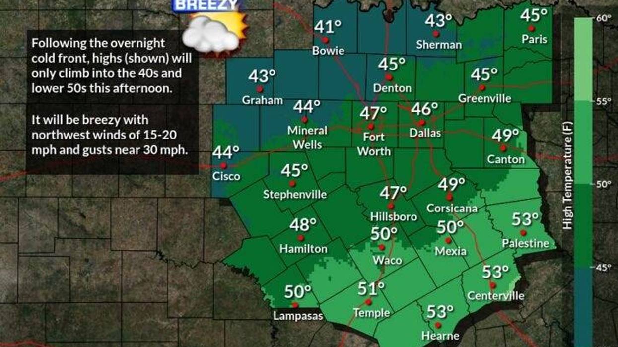
Layer up and bundle up this morning, as temperatures have fallen into the upper thirties to low forties. Factor in the 35mph wind gusts and windchills are in the upper twenties to low thirties. Definitely a shock to the body after highs in the upper seventies yesterday. Decreasing clouds, windy and chilly today with high temperatures only in the mid forties. NNW winds will gust to 35mph.
Protect your plants, pets, and pipes please overnight. Morning lows will dip anywhere between 25゚ and 30゚ across north Texas. The wind will continue to blow from the north and gust to 25mph, creating windchills and the teens!
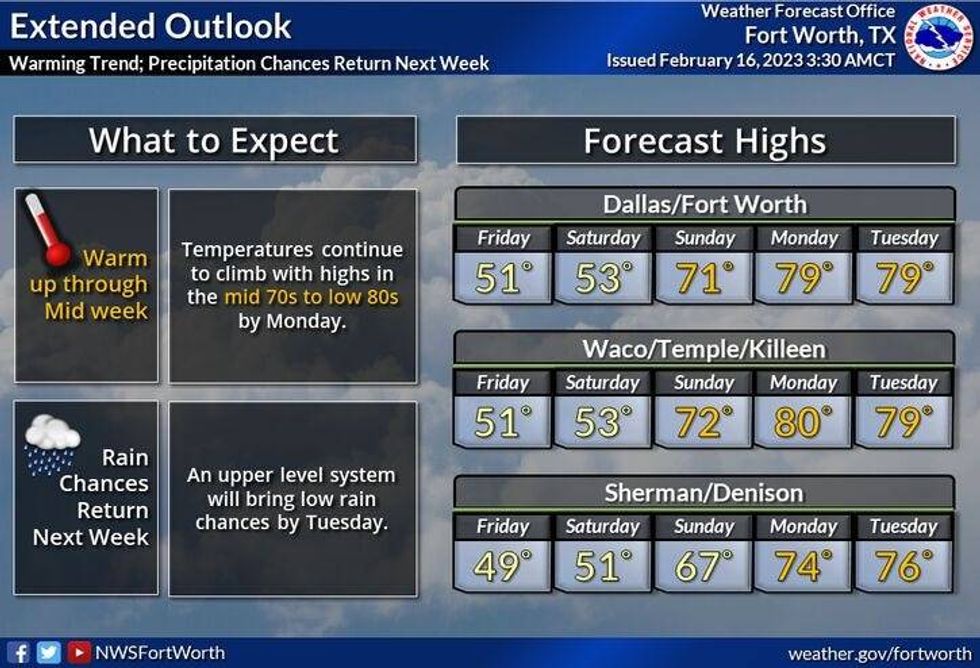
Plenty of sunshine will greet you through the day on Friday, but it will remain cold with less wind. Daytime highs will only reach the low fifties. The average high this time of the year is 61゚.
High clouds will move across the area this weekend with a slow warm up on Saturday. Readings will top out in the upper fifties. A south wind returns on Sunday, warming us up to near 70゚! Heck yeah!
Our warm up continues on Monday and Tuesday with a gusty southerly wind. Morning low clouds and afternoon sunshine will greet you each day with highs near 80゚ temperatures! Heck yeah again! Lol.
Some of the extended data is suggesting that we may see some thunderstorms returning to the area by Wednesday, but that is still days away and is subject to change.
Enjoy the heck out of your Thursday and please enjoy the weather when you can, it's the only weather you've got.
 National Weather Service - Fort Worth
7-Day Headlines:
* DFW reached 77 degrees yesterday.
* Much colder today with a ton of wind.
* Wind chills in the 30s.
* A hard freeze tonight. Plants, pets and pipes.
* Staying cool through Saturday.
* Big warm up Sunday-Tuesday. Storms return Wednesday.
*Yest Rain: 0.00"; High: 77; Low: 45
*Today's Averages: High: 61; Low: 40
*Record high: 85 (2006); Record low: -2 (2021)
*February Rain: 3.48"; Surplus: 2.13"
*2023 Rain: 4.86"; Surplus: 0.98"
*Sunrise: 7:11am; Sunset: 6:14pm
Looking Ahead:
Today: Decreasing clouds, windy and colder. High: Mid 40s. Wind Chills in the 30s. Wind: NNW 20-30, G35 mph.
Tonight: Clear, breezy and cold. Low: 25-30. Windchills in the teens. Wind: NNW 15-25 mph.
Friday: Sunny and cool. Less wind. High: Low 50s.
Saturday: Passing high clouds and seasonable. High: Mid 50s.
Sunday: Passing high clouds, breezy and warmer. High: Near 70.
Monday and Tuesday: Partly cloudy, windy and VERY warm. High: Near 80.
Wednesday: Increasing clouds and warm. Chance of showers and storms. High: Low 70s.
`

LISTEN on the Audacy App
Tell your Smart Speaker to "PLAY 1080 KRLD"
Sign Up and Follow NewsRadio 1080 KRLD