Near average temperatures with pleasant mornings and warm afternoons.. Those are your main weather stories over the next 7 days. Plus, I don't see any rain in the forecast as well.
A large ridge of high pressure in the upper levels of the atmosphere will build across the central plains states, and nose its way into Texas through the rest of the week, this weekend, and most of next week. This means temperatures will be above average and precipitation chances will be zero.
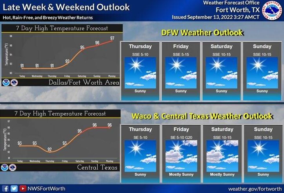
The hottest weather by the weekend will be across the central plains, but we'll be above average with our temperatures here as well. Also, surface moisture returns from the Gulf of Mexico bringing morning low clouds our direction by the end of the week and into the weekend. These clouds will mix out by late morning.
Afternoon highs will be near average with readings near 90° through the rest of the week. Morning lows will range between 65° and 72°.
 National Weather Service - Fort Worth
By this weekend, temperatures in some areas may hit the mid-90s. Mid-90s will be the rule for the first few days of next week as well. These 90s will slowly go away, but it's going to take it a while... 9 more days until the first official day of fall!
*Yest Rain: 0.00"; High: 87; Low: 65
*Today's Averages: High: 89; Low: 70
*Record high: 107 (2011); Record low: 48 (1902)
*September rain: 0.33"; September deficit: 0.87"
*2022 Rain: 23.42"; 2022 deficit: 2.33"
*Sunrise: 7:10am; Sunset: 7:37pm
Today: Sunny and warm. Low humidity. High: Near 90. Wind: South 5-10 mph.
Tonight: Clear and comfortable. Lows: 65-70. Wind: SE 5-10 mph.
Wednesday: Mostly sunny and warm. High: Near 90. Wind: SE 10-15 mph.
Thursday - Friday: Partly cloudy and hot. Highs: Low 90s.
Weekend: Partly cloudy and hot. Highs: Low to mid 90s.
Monday: Partly cloudy and hot. High: Mid 90s.

LISTEN on the Audacy App
Tell your Smart Speaker to "PLAY 1080 KRLD"
Sign Up and Follow NewsRadio 1080 KRLD