The weather will take another 180-degree turn over the next seven days, as spring-like weather arrives in North Texas.
Following a cold January, February is expected to begin with warm temperatures for this time of year. It only gets better through most of next week. A west-to-east flow in the upper levels of the atmosphere, also known as a zonal flow, will control the weather through the middle of next week. With this type of weather pattern, the coldest air remains well north of the Lone Star State, keeping the storm track well north of our area. It's unlikely there will be any rain for the next seven days, and temperatures will continue to be well above average for this time of year.
Afternoon highs on Friday will reach the mid-60s, with north winds gusting up to 25 miles per hour, putting a slight chill in the air.
Plenty of sunshine is expected over the weekend, with highs in the low 70s on Saturday and mid-to-upper 70s on Sunday. Humidity will remain low.
Most of next week will be uneventful, with plenty of sunshine on Monday with afternoon highs approaching 80 degrees. Some areas west of Fort Worth may reach the low to mid-80s.
A cold front will attempt to move into the area on Tuesday, but it will have difficulty passing through the entire state. Sunny skies and 70 degrees, with cooler temperatures near the Red River and warmer temperatures in Central Texas.
As of now, it appears this front will lift back to the north on Wednesday, with afternoon highs returning to the upper 70s. Another cold front may pass through the area on Thursday, cooling temperatures back into the 60s for highs. Again, no rain is forecasted for at least the next seven days.
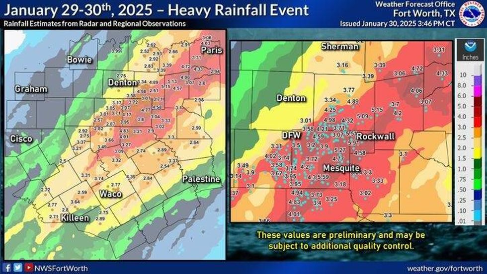 North Texas rainfall totals for Jan. 29-30, 2025.National Weather Service
7-Day Headlines
* DFW Airport reached 69 on Thursday.
* Breezy and cool on Friday.
* Big warming trend this weekend.
* Continued warm next week.
* No rain for a while.
* Next cold front by Thursday. No rain with it as of now.
_____________________________________________________
*Thursday Rain: 0.00"; Thursday High: 69; Low: 52
*Friday's Averages: High: 58; Low: 37
*Record high: 93 (1911); Record low: -2 (1949)
________________________________________________________
*January Rain: 5.69"; Surplus: 3.23"
*2025 Rain: 5.69"; Snow: 2.30"; Surplus: 3.23"
*Sunrise: 7:23am; Sunset: 6:01pm
________________________________________________________
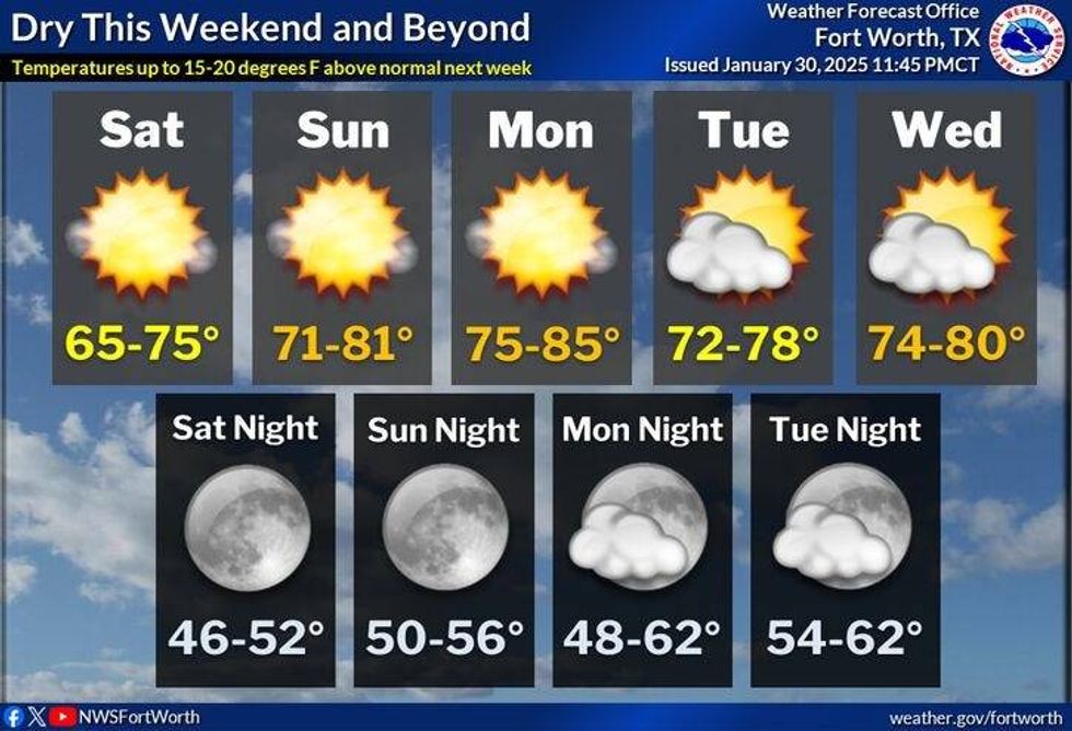
Friday: Sunny, breezy, and cool. Low humidity. High: Mid 60s. Wind: NW 15-25 mph.
Friday night: Clear and chilly. Light wind. Low: 38-42. Wind: Lt. Var.
Saturday: Sunny and mild. High: Near 70. Wind: South 5-10 mph.
Sunday: Mostly sunny, breezy, and warmer. High: Mid to upper 70s.
Monday: Partly cloudy, continued warm. Afternoon cold front. High: Near 80.
Tuesday: Partly to mostly cloudy and a bit cooler. High: Near 70.
Wednesday: Partly cloudy and warm. High: Upper 70s.
Thursday: Partly cloudy and cooler. The next cold front arrives. High: Low 60s.
 North Texas 5-day forecastNational Weather Service
LISTEN on the Audacy App
Tell your Smart Speaker to "PLAY 1080 KRLD"
Sign Up to receive our KRLD Insider Newsletter for more news
Follow us on Facebook | Twitter | Instagram | YouTube