No Arctic air, no stratospheric warming, no hype. Just straightforward North Texas weather helping you plan out your daily routines over the next 7 days.
Good morning, folks. As you step outside, you will notice that most of the ice on the north sides of your homes, especially driveways and patios, has almost melted away. With high relative humidity and temperatures only in the mid to upper 50s this morning, the remaining ice is rapidly disappearing.
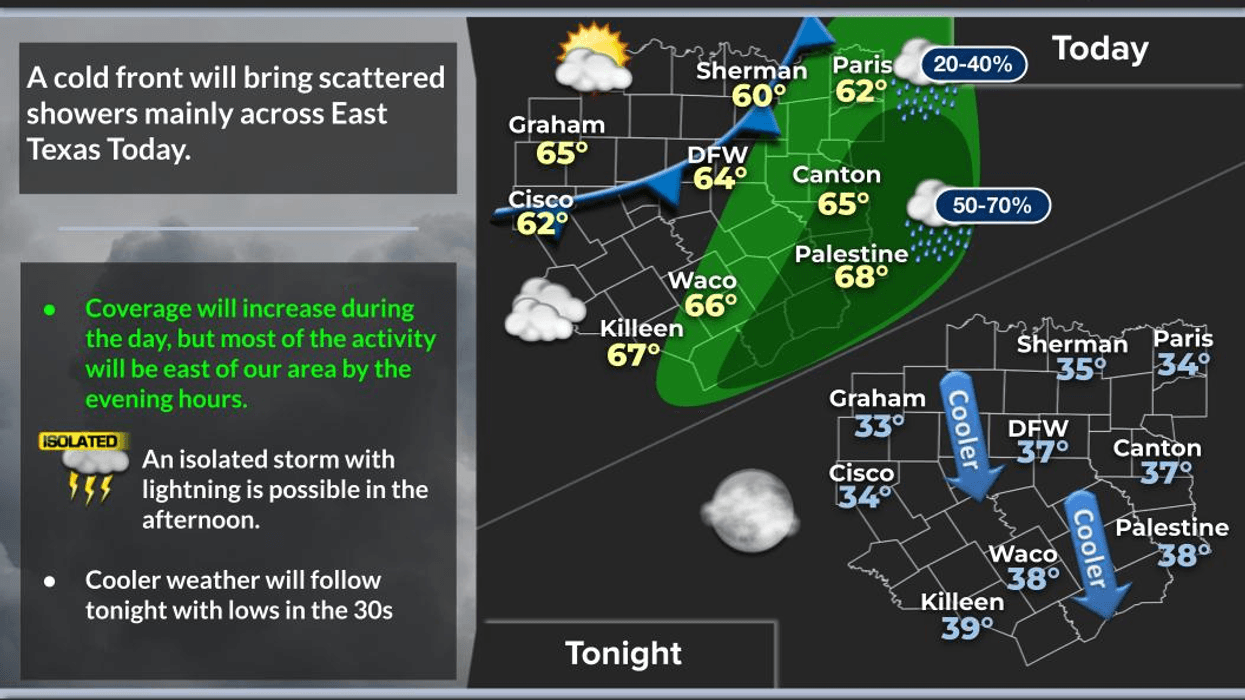
A layer of cloud cover and a slight chance of rain 50 to 80 miles to our east may impact your commute if you live far from Dallas and Fort Worth. However, this precipitation should remain east of the DFW area throughout the day.
The clouds will persist, and temperatures will warm into the mid-60s. By late afternoon, a cold front will move through the area, bringing a noticeable shift in the weather. There will be a thin area of showers developing along the front, mainly along and south of I-30. The wind will shift to the northwest, with gusts reaching up to 25 mph through the evening. This will cause temperatures to drop into the mid to upper 30s by Wednesday morning. Expect jacket weather to return.
Abundant sunshine will dominate Wednesday afternoon, with temperatures rising into the mid to upper 50s, which is average for this time of year.
Areas outside of Dallas and Fort Worth may experience a light freeze on Thursday morning. However, temperatures within the city will remain above freezing, with readings falling into the mid to upper 30s under clear skies. Thursday will be sunny and beautiful, with highs returning to the mid-60s.
Our warm-up will continue Friday through the weekend, with plenty of sunshine. Afternoon highs on Friday will approach 70°F, with temperatures reaching the low to mid-70s through the weekend. Morning lows will only drop into the 50s. We will experience early spring-like weather once again.
Our next weather change is due to arrive early next week as another system approaches from the west. Rain chances may increase slightly on Monday and Tuesday, along with cooler weather, as the storm system exits the area before next Wednesday. And again, no Arctic air is expected anytime soon.
Have a great day y'all! I appreciate your loyalty and encourage you to enjoy the weather when you can, it's the only weather you've got!
7-Day Headlines:
* DFW Airport reached 70 yesterday.
* A few showers SE of I-30 today. Afternoon cold front.
* A bit cooler Wednesday and Thursday.
* Light freezes Wednesday and Thursday mornings
* Warming up Friday - Sunday.
* 70s this weekend!
* Watching early next week for rain to return.
*Yest Rain: 0.00"; Yest High: 70; Low: 33
*Today's Averages: High: 59; Low: 38
*Record high: 84 (1911); Record low 14 (1905, 1985, 1996)
__________________________________________________________
*February rain: 0.00"; Deficit:
*2026 Rain: 0.93"; Snow: 2.4" Deficit:
*Sunrise: 7:21am; Sunset: 6:04pm
__________________________________________________________
Tuesday: Morning and early afternoon clouds with a few showers, especially along and south of I-30. Afternoon cold front. Decreasing clouds, breezy and cooler. High: Mid 60s. Wind: South to NW 10-20, G25 mph.
Tuesday night: Clear, breezy and chilly. Low: Mid to upper 30s. Wind: North 10-15 mph.
Wednesday: Sunny, breezy and cool. High: Mid to upper 50s. Wind: North 10-20 mph.
Thursday: Sunny and perfect! Low: Low to mid 30s; High: Mid 60s.
Friday: Sunny and awesome! Golf anyone? High: Near 70.
Weekend: Mostly sunny and spectacular! Highs: Low to mid 70s.
Monday: Mostly cloudy and mild. Chance of rain may return. High: Low 70s.