A low-pressure system is currently bringing changes to the weather patterns across North Texas, with waves of showers and thunderstorms forecasted for late this evening, continuing intermittently through noon on Saturday. It is essential to remain weather-aware throughout this period.
Good morning and welcome to Wednesday. As previously mentioned, our weather pattern is gradually shifting as we enter April. This morning, temperatures are relatively cool, with no severe weather expected. However, a cluster of leftover showers will pass through the northern counties until 7am. The cloud cover is extensive, and temperatures are unusually mild for this time of year, ranging from the mid to upper 60s, making jackets unnecessary.
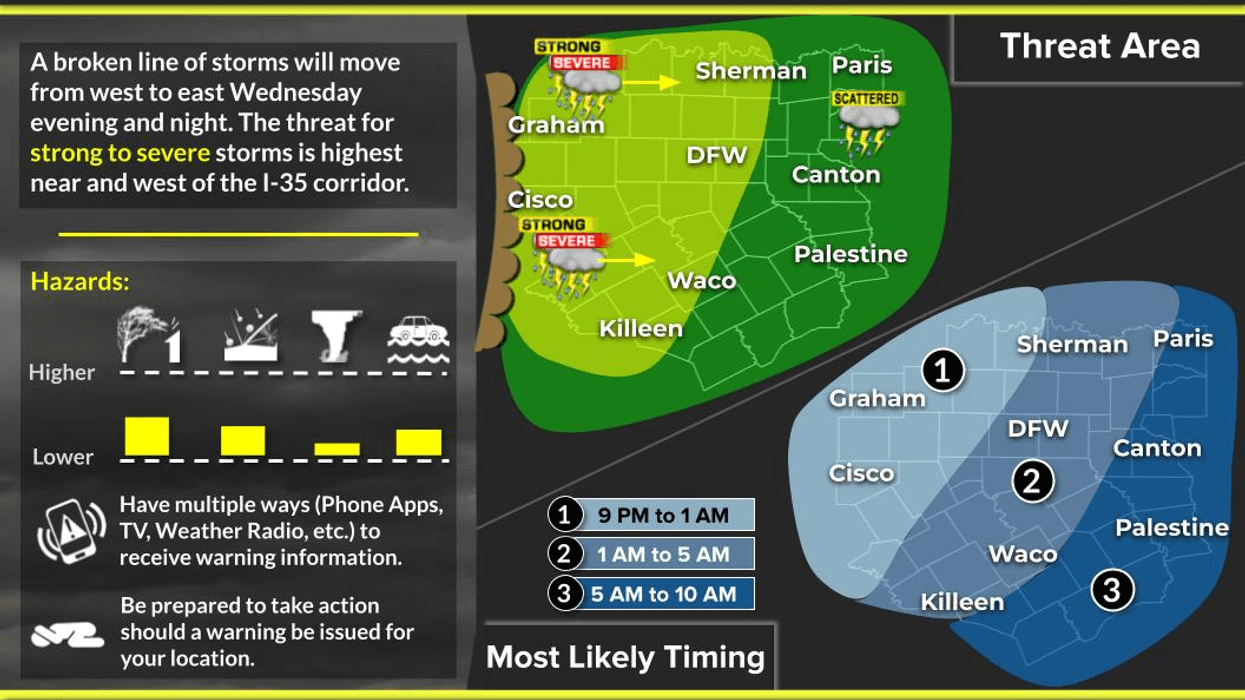
We can expect breaks in the cloud cover this afternoon, allowing temperatures to rise to the mid-80s. The south wind will gust up to 30 mph. By late this afternoon, a cluster of storms will form west of the Dallas-Fort Worth area, along the dryline, affecting areas such as the northern Hill Country, Big Country, and Red River Valley. These regions have levels 2 and 3 out of 5 in place for severe weather.
As the individual storms coalesce into a line of showers and storms, they will move towards the Dallas-Fort Worth area late this evening, weakening as they approach the 35W corridor. While severe thunderstorm warnings are unlikely, there is still a possibility of small hail and gusty winds between 10:00 p.m. this evening and 2:00 a.m. Thursday morning. The situation will be different west of 35W through late evening.
All precipitation will move south and east of the area before daybreak on Thursday, although clouds will linger through mid to late morning. Morning lows will dip into the lower 60s, with afternoon highs on Thursday reaching the mid-80s, accompanied by breaks in the clouds.
Friday will begin with cloudy and mild conditions, with temperatures falling into the 60s. Partly cloudy skies are expected in the afternoon, with highs returning to the mid-80s. The dry line in Far West Texas will become active late Friday afternoon, producing scattered strong to severe thunderstorms. This area of storms will move towards North Texas by mid-evening on Friday, posing a severe weather threat, which will be addressed as the event approaches.
A brief respite is expected late Friday night into early Saturday morning before a cold front arrives mid-morning on Saturday. As of now, a decent line of showers and storms, with isolated severe pockets, is expected to pass through the area before noon on Saturday, with wind being the primary threat. The front will move south and east of the area after the noon hour on Saturday, ushering in cooler air. A few showers might persist behind the front as clouds linger throughout the day, with temperatures falling through the 60s, making for a blustery day.
Clouds will stick around for Easter, but the morning will be rather cool for Easter egg hunts, with a north wind of 10 to 15 mph. Plenty of sunshine is forecasted for Easter afternoon, with highs reaching the mid to upper 60s. Monday and Tuesday of next week will begin with temperatures in the 40s, warming up to the mid-70s during the afternoon, making for two beautiful spring days following Easter Sunday.
As of now, it appears that the weather will become active again towards the end of next week into the following weekend. I will continue to monitor the storms late this evening, but I'm not overly concerned.
Have a great day today and enjoy the weather when you can, it's the only weather you've got.
7-Day Headlines:
- DFW Airport reached 86 on Wednesday
- Our windy week continues
- Above average temperatures until the weekend
- Scattered severe storms late Wednesday, and late Friday through noon Saturday
- Threats: Small hail & gusty wind
- Decent Saturday morning cold front
- Mostly cloudy and cool for Easter Sunday
Almanac:
- Yest Rain: 0.00”; Yest High: 86; Low: 66
- Today’s Averages: High: 73; Low: 52
- Record high: 93 (1918); Record low 31 (1899)
- March rain: 2.92”; Deficit: <0.38”>
- 2026 Rain: 5.16”; Snow: 2.4” Deficit: <3.43”>
- Sunrise: 7:15am; Sunset: 7:49pm
7-Day Forecast:
Wednesday: Morning clouds/sprinkles north of DFW, afternoon sun. Windy and warm. High: Mid 80s. South 15-25, G30 mph.
Wednesday night: Weakening Texas squall line blows through after 10pm. Threats: Small hail, gusty wind, and lightning. Low: Mid 60s.
Thursday: Morning showers (south of I-20), then partly cloudy and warm. High: Mid 80s.
Friday: Morning clouds, afternoon sun. Windy and warm. Showers and isolated severe storms arrive by evening. Threats: Hail, gusty wind, an isolated tornado. High: Mid 80s.
Saturday: Morning showers and storms are a good bet. Heavy rain and severe threat drifts south after lunch. Mid morning cold front. Staying cloudy, becoming windy and cooler. High: 70 early, falling into the 60s.
Easter Sunday: Mostly cloudy and cool. Low: Low 50s. High: Mid 60s.
Monday: Partly cloudy and beautiful. High: Low 70s.
Tuesday: Partly cloudy and pleasant. High: Mid 70s.
LISTEN on the Audacy App
Tell your Smart Speaker to "PLAY 1080 KRLD"
Sign Up to receive our KRLD Insider Newsletter for more news
Follow us on Facebook | Twitter | Instagram | YouTube