Well, folks, it's finally Friday, and you know what that means - time to dance in the rain. A period of light to moderate rain will persist across North Texas throughout the day, because who needs sunshine on a Friday, anyway? It'll all come to an end this evening, just in time for your weekend shenanigans. And speaking of the weekend, it's looking pleasant, followed by a gradual warm-up through Tuesday of next week, because Mother Nature loves to keep us on our toes. Prior to our next cold front bringing cooler temperatures by the middle of next week, we'll get to enjoy some lovely weather.
We are currently experiencing light rain across North Texas, with temperatures ranging from the mid to upper 50s, and we anticipate remaining in the 50s throughout the day, with waves of light to moderate rain moving south of Highway 380. Don't worry, it's unlikely that the DFW area will receive more than half an inch of rain, so you won't need to break out the scuba gear just yet. Rainfall totals will be lower to the north and higher to the south, because that's just how the weather cookie crumbles. The rain will taper off from west to east by this evening, just in time for your Friday night plans.
Tomorrow morning will bring areas of fog and low clouds, which will rapidly dissipate, giving way to a beautiful Saturday - yay. Morning lows will dip to near 50 degrees, while afternoon highs will reach the mid-70s, making it the perfect day to get outside and enjoy the fresh air. Sunday is expected to be equally pleasant, with lows in the low 50s and daytime highs approaching 80 degrees, because who doesn't love a good Sunday Funday? Enjoy the weekend, folks.
A rapid warm-up will commence on Monday, with temperatures reaching the low 80s, and potentially approaching 90 degrees by Tuesday, ahead of our next cold front - buckle up, it's going to be a wild ride. This front is expected to move through the area late Tuesday, bringing a chance of showers and storms, mainly south and east of the Dallas-Fort Worth area, where moisture will have more time to accumulate at the surface. I'll provide an update on the rain coverage early next week, so stay tuned.
Wednesday will be sunny, breezy, and much cooler, with highs in the mid-70s, making it the perfect day to fly a kite. Thursday will bring plenty of sunshine, with highs in the upper 70s, because who doesn't love a good Thursday?
As of now, our next weather system is expected to arrive Friday into next weekend, but it's too early to determine the severity, so let's just cross our fingers and hope for the best. While it is too early to determine the severity, the rapid succession of these systems may limit the accumulation of surface moisture, potentially resulting in lower severity but higher coverage - weather is so complicated. Please stay tuned for further updates, as this is beyond my 7-day forecast.
Enjoy the rain today, exercise caution regarding flooding south of the Dallas-Fort Worth area, and have a great weekend. Always remember to appreciate the weather when you can, as it is the only weather you have, so make the most of it.
7-Day Headlines:
- DFW Airport hit 64 degrees on Thursday.
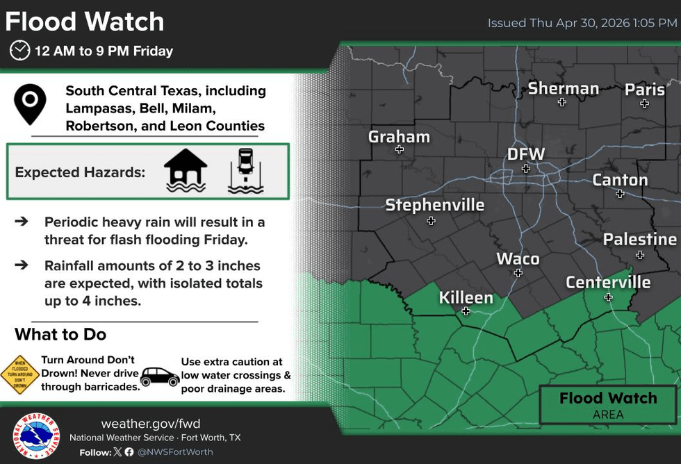
- Waves of rain today, Flood Watch to our south
- Temperatures hover in the 50s today
- Sunshine returns this weekend, highs in the 70s
- Warming next week
- The next cold front arrives late Tuesday
- Download our AUDACY app. Listen to KRLD at home!
Almanac:
- Yest Rain: 0.05”; Yest High: 64; Low: 57
- Today’s Averages: High: 79; Low: 60
- Record high: 92 (1948, 2002); Record low 34 (1903)
- April rain: 5.06”; Surplus: 1.84”
- 2026 Rain: 10.22”; Snow: 2.4” Deficit: <1.59”>
- Sunrise: 6:40am; Sunset: 8:11pm
Forecast:
Friday: Cloudy and cool. Waves of rain all day. Nothing severe. (0.50” at DFW Airport, lighter totals north of hwy 380, heavier totals south of I-20) High: 50s. Wind: ENE 10-20 mph.
Friday night: Cloudy, breezy and cool. Areas of drizzle. Low: Near 50. Wind: Variable 5-10 mph.
Saturday: Decreasing clouds and beautiful! High: Low to mid 70s. Wind: NW 5-10 mph.
Sunday: Increasing high clouds. High: Near 80.
Monday: Partly cloudy, breezy and nice! High: Low 80s.
Tuesday: Partly cloudy, breezy and warmer. Cold front late. A slight chance of rain. High: Near 90.
Wednesday: Partly cloudy and cooler. High: Mid 70s
Thursday: Partly cloudy and comfortable. High: Upper 70s.
LISTEN on the Audacy App
Tell your Smart Speaker to "PLAY 1080 KRLD"
Sign Up to receive our KRLD Insider Newsletter for more news
Follow us on Facebook | Twitter | Instagram | YouTube